METAR & TAF 8WC
8WC does not publish a METAR.
Showing the nearest reporting station: KFAM (FARMINGTON RGNL) · 17.6 NM away. Conditions at 8WC may differ.
METAR · KFAM
Observed 12:56Z
KFAM 271256Z AUTO 20007G15KT 10SM CLR 26/21 A3001 RMK AO2 SLP160 T02610206 $
- Wind
- 200° @ 7G15 kt
- Visibility
- 10 SM
- Temp / Dew
- 26°C / 21°C
- Altimeter
- 30.01 inHg
- Clouds
- CLR
- Density alt
- 2,398 ft
- Ceiling
- Unlimited
- Rules
- VFR
Airport info & contacts
Manager on record, flight service, ARTCC, attendance schedule and pattern altitude — published by the FAA and refreshed every 28 days.
Location
- From city
- 3 NM E
- VFR sectional
- ST LOUIS
- ARTCC
- ZKC · KANSAS CITY
- NOTAM facility
- STL (NOTAM-D)
Airport manager
- Name
- DANNY WILSON
- Phone
- 573-854-9173
- Address
- 12225 EAST STATE HIGHWAY 8, MINERAL POINT MO 63660
Flight service · Hours
- FSS STL
- SAINT LOUIS1-800-WX-BRIEF
- Attendance
- MON-FRI · 0800-1630
Frequencies
Tap any row to copy the frequency to your clipboard.
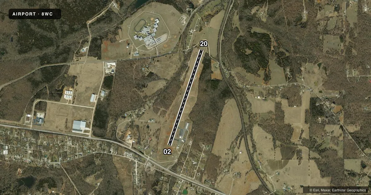
Runways & pattern
Full pagePattern entry · RWY 20
LEFT TRAFFICAirport sketch
Runways drawn to scale from FAA survey coordinates, rendered over satellite imagery. Not for navigation.
Approaches & charts
Services on the field
Fuel grades, oxygen, maintenance, ramp storage and lighting — as declared to the FAA by the airport operator.
Fuel & services
- Fuel
- 100LLA+
- Oxygen (bottled)
- Not available
- Oxygen (bulk)
- Not available
Ramp & ground
- Transient storage
- Tie-down
- Landing fee
- No fee published
- Customs
- Not available
- Lighting schedule
- SEE RMK
- Beacon schedule
- SS-SR
- Beacon
- White / Green (civil land)(WG)
- Wind indicator
- Lighted
- Segmented circle
- Yes
Fuel & FBOs
Cheapest 100LL and Jet A on the field and nearby. Always confirm with the FBO before taxi.
Airport notes
Surface conditions, obstructions, local procedures, lighting outages and other notes published with each FAA cycle.
General notes
- WILDLIFE ON & INVOF ARPT.
- USE RIGHT TFC FOR RY 02; DO NOT OVERFLY PRISON AREA.
- 24-HR SS 100LL AND JET-A FUEL LOCATED AT SOUTH APRON.
- FOR CD CTC KANSAS CITY ARTCC AT 913-254-8508.
Lighting notes
- ACTVT MIRL RY 02/20 - CTAF.
Runway surface & condition
- 02/20PAVEMENT RATED FOR ACFT UNDER 12,500 LBS.
VFR map & nearby airports
VFR sectional. Tap any ICAO chip to open that airport.
Key facts · 8WC
Answer card- ICAO
- 8WC
- Name
- WASHINGTON COUNTY
- Location
- POTOSI, MISSOURI
- Elevation
- 959.3 ft MSL
- Traffic pattern altitude
- 1,959.3 ft MSL (1,000 AGL)
- Control tower
- Non-towered (use CTAF)
- Total runways
- 1
- Longest runway
- 02/20 · 4,000 ft
- Published ILS approaches
- 0
- Published frequencies
- 2
- Magnetic variation
- 0°
- Current flight rules
- VFR
- Current wind
- 200° at 7 kt
- Favored runway now
- RWY 20
Washington County Airport (8WC) sits in Potosi, Missouri. The field elevation is 959.3 ft MSL. It has one runway. Runway 02/20 is 4,000 ft asphalt, so that is the longest runway on the field. There is no control tower. CTAF and UNICOM are both 123.0. No ILS approaches are published here.
Pattern altitude is not published. Use the standard 1,000 ft AGL pattern unless local procedures or the current Chart Supplement say otherwise. For runway 02, use right traffic. Do not overfly the prison area. Wildlife is reported on and near the airport, so keep a sharp scan on arrival and departure. Medium intensity runway lights for 02/20 are activated by CTAF.
Washington County Airport is on the field and carries AVGAS 100LL and Jet-A. The published remarks say 24-hour sunset service for both fuels is on the south apron. Clearance delivery is handled through Kansas City ARTCC at 913-254-8508. The pavement is rated for aircraft under 12,500 pounds. For a first-time stop, plan for an uncontrolled airport with local traffic on 123.0. Check the current Chart Supplement for any additional local procedures before you go.