METAR & TAF 6K2
6K2 does not publish a METAR.
Showing the nearest reporting station: KMBY (OMAR N BRADLEY) · 27.2 NM away. Conditions at 6K2 may differ.
METAR · KMBY
Observed 07:15Z
KMBY 270715Z AUTO 20005KT 10SM CLR 27/25 A2988 RMK AO2
- Wind
- 200° @ 5 kt
- Visibility
- 10 SM
- Temp / Dew
- 27°C / 25°C
- Altimeter
- 29.88 inHg
- Clouds
- CLR
- Density alt
- 2,432 ft
- Ceiling
- Unlimited
- Rules
- VFR
Airport info & contacts
Manager on record, flight service, ARTCC, attendance schedule and pattern altitude — published by the FAA and refreshed every 28 days.
Location
- From city
- 1 NM NW
- VFR sectional
- KANSAS CITY
- ARTCC
- ZKC · KANSAS CITY
- NOTAM facility
- COU (NOTAM-D)
Airport manager
- Name
- GINA MESMER
- Phone
- 573-633-2520
- Address
- 106 S WASHINGTON BOX 90, SHELBYVILLE MO 63469
Flight service · Hours
- FSS COU
- COLUMBIA1-800-WX-BRIEF
- Attendance
- Unattended
Frequencies
Tap any row to copy the frequency to your clipboard.
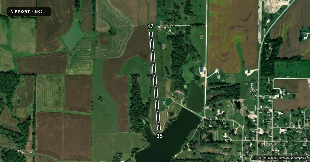
Runways & pattern
Full pagePattern entry · RWY 17
LEFT TRAFFICRunway end performance
| End | TORA | TODA | ASDA | LDA | VGSI | Approach lights | Obstruction |
|---|---|---|---|---|---|---|---|
| 17 | — | — | — | — | — | — | 4', fence, 80' from thr, 0' R of cntrln, slope 20 |
| 35 | — | — | — | — | — | — | 72', tree, 1030' from thr, 100' R of cntrln, slope 14 |
Declared distances in feet. TORA = takeoff run available, TODA = takeoff distance, ASDA = accelerate-stop, LDA = landing distance.
Airport sketch
Runways drawn to scale from FAA survey coordinates, rendered over satellite imagery. Not for navigation.
Approaches & charts
Services on the field
Fuel grades, oxygen, maintenance, ramp storage and lighting — as declared to the FAA by the airport operator.
Fuel & services
- Fuel
- Not available
- Oxygen (bottled)
- Not available
- Oxygen (bulk)
- Not available
- Airframe repair
- Not available
- Power plant repair
- Not available
Ramp & ground
- Transient storage
- Tie-down
- Landing fee
- No fee published
- Wind indicator
- Yes
- Segmented circle
- No
Fuel & FBOs
Cheapest 100LL and Jet A on the field and nearby. Always confirm with the FBO before taxi.
Airport notes
Surface conditions, obstructions, local procedures, lighting outages and other notes published with each FAA cycle.
General notes
- HVY CONCENTRATION OF LRG WATER FOWL ON & INVOF ARPT.
- NTSD RWY SAFETY AREA BEYOND EACH RWY END; RWY 17 HAS FENCE 80 FT FM THR; RWY 35 HAS LARGE DROP OFF AND LAKE.
- FOR CD CTC KANSAS CITY ARTCC AT 913-254-8508.
- RWY 17 FARM EQUIPMENT 6-8 FT TALL 145 FT FROM RWY END
Approach & departure obstructions
- 1717/35 MKD WITH LARGE YELLOW CONES.
- 35RWY 35 MKD WITH NRS AT THR.
Other notes
- PROVIDED THE APPROACH TO EACH RWY IS MAINTAINED FOR A MINIMUM 20:1 GLIDE SLOPE AND THE TRANSITIONAL SURFACE BE MAINTAINED FOR A 7:1 SLOPE.
- MANAGERCTC PERSON: CITY CLERK.
VFR map & nearby airports
VFR sectional. Tap any ICAO chip to open that airport.
Key facts · 6K2
Answer card- ICAO
- 6K2
- Name
- SHELBY COUNTY
- Location
- SHELBYVILLE, MISSOURI
- Elevation
- 760 ft MSL
- Traffic pattern altitude
- 1,760 ft MSL (1,000 AGL)
- Control tower
- Non-towered (use CTAF)
- Total runways
- 1
- Longest runway
- 17/35 · 2,300 ft
- Published ILS approaches
- 0
- Published frequencies
- 1
- Magnetic variation
- 3°
- Current flight rules
- VFR
- Current wind
- 200° at 5 kt
- Favored runway now
- RWY 17
Shelby County Airport is in Shelbyville, Missouri. The field elevation is 760 ft MSL. It has one runway, 17/35, which is 2,300 ft of turf. There is no control tower. CTAF is 122.9.
No ILS approaches are published here. The pattern altitude is not published in the facts, so use the standard 1,000 ft AGL pattern unless the current Chart Supplement says otherwise. Clearance delivery is handled through Kansas City ARTCC at 913-254-8508. That is worth having handy if you need it before departure.
The published remarks matter here. Runway 17 has farm equipment near the departure end. Runway 17 also has a fence close to the threshold. Runway 35 has a large drop off and a lake beyond it. There is also a heavy concentration of large waterfowl on and near the airport. Runways 17 and 35 are marked with large yellow cones. Runway 35 has non-precision runway markings at the threshold.
No on-field FBOs are listed. Contact the airport operator directly or call the field on CTAF for current service details. The contact person listed in the remarks is the City Clerk. First-time pilots should plan for a short turf strip with no standard runway safety area beyond either end, plus the bird activity and the terrain off the 35 end.