METAR & TAF KTRX
KTRX does not publish a METAR.
Showing the nearest reporting station: KLWD (LAMONI MUNI) · 35.9 NM away. Conditions at KTRX may differ.
METAR · KLWD
Observed 16:53Z
KLWD 271653Z AUTO 22009KT 10SM CLR 33/23 A2980 RMK AO2 SLP080 T03280228
- Wind
- 220° @ 9 kt
- Visibility
- 10 SM
- Temp / Dew
- 33°C / 23°C
- Altimeter
- 29.80 inHg
- Clouds
- CLR
- Density alt
- 3,248 ft
- Ceiling
- Unlimited
- Rules
- VFR
Airport info & contacts
Manager on record, flight service, ARTCC, attendance schedule and pattern altitude — published by the FAA and refreshed every 28 days.
Location
- From city
- 1 NM E
- VFR sectional
- OMAHA
- ARTCC
- ZKC · KANSAS CITY
- NOTAM facility
- COU (NOTAM-D)
Airport manager
- Name
- WESLEY BARONE
- Phone
- (660) 359-2013
- Address
- 1100 MAIN ST., PO BOX 188, TRENTON MO 64683
Flight service · Hours
- FSS COU
- COLUMBIA1-800-WX-BRIEF
- Attendance
- MON-FRI · 0730-1630
Frequencies
Tap any row to copy the frequency to your clipboard.
Runways & pattern
Full pagePattern entry · RWY 18
LEFT TRAFFICRunway end performance
| End | TORA | TODA | ASDA | LDA | VGSI | Approach lights | Obstruction |
|---|---|---|---|---|---|---|---|
| 18 | — | — | — | — | PAPI 4-box left(3°) | — | 15', road, 240' from thr, 260' R of cntrln, slope 2 |
| 36 | — | — | — | — | PAPI 4-box left(3°) | — | — |
Declared distances in feet. TORA = takeoff run available, TODA = takeoff distance, ASDA = accelerate-stop, LDA = landing distance.
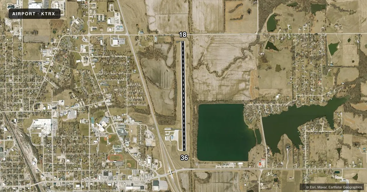
Airport sketch
Runways drawn to scale from FAA survey coordinates, rendered over satellite imagery. Not for navigation.
Approaches & charts
Services on the field
Fuel grades, oxygen, maintenance, ramp storage and lighting — as declared to the FAA by the airport operator.
Fuel & services
- Fuel
- 100LLA
- Oxygen (bottled)
- Not available
- Oxygen (bulk)
- Not available
Ramp & ground
- Transient storage
- Tie-down
- Landing fee
- No fee published
- Customs
- Not available
- Lighting schedule
- SEE RMK
- Beacon schedule
- SS-SR
- Beacon
- White / Green (civil land)(WG)
- Wind indicator
- Lighted
- Segmented circle
- No
Fuel & FBOs
Cheapest 100LL and Jet A on the field and nearby. Always confirm with the FBO before taxi.
Airport notes
Surface conditions, obstructions, local procedures, lighting outages and other notes published with each FAA cycle.
General notes
- BE ALERT FOR BIRDS & WILDLIFE ON AND INVOF ARPT.
- FOR CD CTC KANSAS CITY ARTCC AT 913-254-8508.
Lighting notes
- MIRL RY 18/36 & PAPI RYS 18 & 36 OPER DUSK-2130; AFT 2130 TO DUSK ACTVT MIRL RY 18/36, PAPI RYS 18 & 36, REIL RYS 18 & 36 - CTAF. TO INCR INTST & ACTVT REIL RYS 18 & 36 - CTAF.
- ULTRALIGHT ACTIVITY ON & INVOF ARPT.
Fuel notes
- 100LL24 HR FUEL AVBL; CTC AMGR (660)359-2013; AFTER HRS CTC FIRE DEPT (660)359-5552.
Approach & departure obstructions
- 1842:1 TO DTHR.
VFR map & nearby airports
VFR sectional. Tap any ICAO chip to open that airport.
Key facts · KTRX
Answer card- ICAO
- KTRX
- Name
- TRENTON MUNI
- Location
- TRENTON, MISSOURI
- Elevation
- 757.5 ft MSL
- Traffic pattern altitude
- 1,757.5 ft MSL (1,000 AGL)
- Control tower
- Non-towered (use CTAF)
- Total runways
- 1
- Longest runway
- 18/36 · 4,307 ft
- Published ILS approaches
- 0
- Published frequencies
- 2
- Magnetic variation
- 3°
- Current flight rules
- VFR
- Current wind
- 220° at 9 kt
- Favored runway now
- RWY 18
Trenton Muni (KTRX) sits in Trenton, Missouri. Field elevation is 757.5 ft MSL. The airport has one runway. Runway 18/36 is 4,307 ft long on asphalt. There is no control tower. CTAF and UNICOM are both 122.8. No ILS approaches are published here.
Pattern altitude is not published in the facts. Use the current FAA Chart Supplement before you fly. The field is a simple single-runway airport. The published remarks matter. Medium intensity runway lights and the PAPI on both ends operate from dusk to 2130. After 2130 until dusk, you can activate the runway lights, the PAPI and the runway end identifier lights by keying CTAF. The remarks also note ultralight activity on and near the airport. Bird and wildlife activity is also a published concern.
Trenton Municipal Airport is the on-field FBO. It carries 100LL and Jet A. 24-hour fuel is available. Call the airport manager at (660) 359-2013. After hours, contact the fire department at (660) 359-5552. Runway 18 has a published obstacle clearance slope to the displaced threshold. Plan your approach carefully. Check the current Chart Supplement for details before arrival.