METAR & TAF KEZZ
Current METAR
Observed 18:55Z
KEZZ 271855Z AUTO 22010KT 10SM CLR 35/24 A2983 RMK AO2
- Wind
- 220° @ 10 kt
- Visibility
- 10 SM
- Temp / Dew
- 35°C / 24°C
- Altimeter
- 29.83 inHg
- Clouds
- CLR
- Density alt
- 3,801 ft
- Ceiling
- Unlimited
- Rules
- VFR
Airport info & contacts
Manager on record, flight service, ARTCC, attendance schedule and pattern altitude — published by the FAA and refreshed every 28 days.
Location
- From city
- 2 NM SW
- VFR sectional
- KANSAS CITY
- ARTCC
- ZKC · KANSAS CITY
- NOTAM facility
- COU (NOTAM-D)
Airport manager
- Name
- ERIC EVANS
- Phone
- 816-632-2423
- Address
- 11766 NORTHEAST A HWY, CAMERON MO 64429
Flight service · Hours
- FSS COU
- COLUMBIA1-800-WX-BRIEF
- Attendance
- MON-FRI · 0900-1700
- SAT · IREG
Frequencies
Tap any row to copy the frequency to your clipboard.
Runways & pattern
Full pagePattern entry · RWY 17
LEFT TRAFFICRunway end performance
| End | TORA | TODA | ASDA | LDA | VGSI | Approach lights | Obstruction |
|---|---|---|---|---|---|---|---|
| 17 | — | — | — | — | PAPI 4-box left(3°) | — | 39', trees, 1234' from thr, 310' R of cntrln, slope 26 |
| 35 | — | — | — | — | PAPI 4-box left(3°) | — | — |
Declared distances in feet. TORA = takeoff run available, TODA = takeoff distance, ASDA = accelerate-stop, LDA = landing distance.
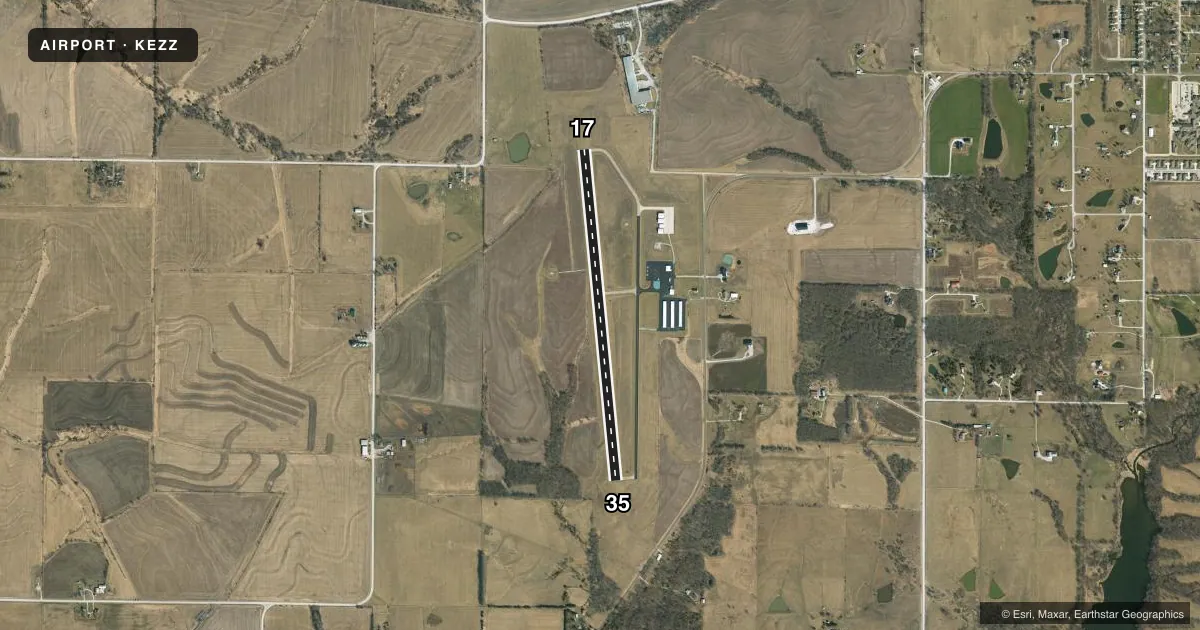
Airport sketch
Runways drawn to scale from FAA survey coordinates, rendered over satellite imagery. Not for navigation.
Approaches & charts
Services on the field
Fuel grades, oxygen, maintenance, ramp storage and lighting — as declared to the FAA by the airport operator.
Fuel & services
- Fuel
- 100LL
- Other services
- INSTR,RNTL,SALES
Ramp & ground
- Transient storage
- Tie-down
- Hangar
- Landing fee
- No fee published
- Lighting schedule
- SEE RMK
- Beacon schedule
- SS-SR
- Beacon
- White / Green (civil land)(WG)
- Wind indicator
- Lighted
- Segmented circle
- Yes
Fuel & FBOs
Cheapest 100LL and Jet A on the field and nearby. Always confirm with the FBO before taxi.
Airport notes
Surface conditions, obstructions, local procedures, lighting outages and other notes published with each FAA cycle.
General notes
- FOR CD CTC KANSAS CITY APCH AT 816-329-2710.
Lighting notes
- MIRL RY 17/35, PAPI RYS 17 & 35, REIL RYS 17 & 35 OPER DUSK-2400; AFT 2400 ACTVT & INCR INTS - CTAF.
- ULTRALIGHT ACTVTY ON & INVOF ARPT.
Fuel notes
- 100LLAUTOMATED SELF FUEL AVBL 24 HRS.
VFR map & nearby airports
VFR sectional. Tap any ICAO chip to open that airport.
Key facts · KEZZ
Answer card- ICAO
- KEZZ
- Name
- CAMERON MEML
- Location
- CAMERON, MISSOURI
- Elevation
- 1,040.1 ft MSL
- Traffic pattern altitude
- 2,040.1 ft MSL (1,000 AGL)
- Control tower
- Non-towered (use CTAF)
- Total runways
- 1
- Longest runway
- 17/35 · 4,000 ft
- Published ILS approaches
- 0
- Published frequencies
- 5
- Magnetic variation
- 3°
- Current flight rules
- VFR
- Current wind
- 220° at 10 kt
- Favored runway now
- RWY 17
Cameron Memorial Airport sits in Cameron, Missouri. The field elevation is 1,040.1 ft MSL. It has one runway. Runway 17/35 is 4,000 ft long with concrete pavement. There is no control tower. Pattern altitude is not published, so use the standard 1,000 ft AGL for light piston operations unless the current Chart Supplement says otherwise.
No ILS approaches are published here. If you are planning an IFR arrival, work from the current Chart Supplement and your normal approach planning tools before you go. Kansas City Approach handles the published approach and departure frequencies. Clearance delivery is also handled through Kansas City Approach by phone.
Cameron Memorial Airport has one on-field FBO. Cameron Memorial Airport carries AVGAS 100LL. Automated self-serve fuel is available 24 hours. Runway 17/35 has medium intensity lighting. PAPI is installed on both runway ends. REILs operate on both ends from dusk to 2400. After 2400, lighting activation and higher intensity are controlled by CTAF. Ultralight activity also occurs on and near the airport, so keep your scan active in the pattern and on final.