METAR & TAF KSNH
Current METAR
Observed 05:10Z
KSNH 270510Z AUTO 07011G23KT 10SM SCT032 BKN041 BKN048 27/22 A2995 RMK A01
- Wind
- 070° @ 11G23 kt
- Visibility
- 10 SM
- Temp / Dew
- 27°C / 22°C
- Altimeter
- 29.95 inHg
- Clouds
- BKN
- Density alt
- 1,989 ft
- Ceiling
- 4,100 ft AGL
- Rules
- VFR
Airport info & contacts
Manager on record, flight service, ARTCC, attendance schedule and pattern altitude — published by the FAA and refreshed every 28 days.
Location
- From city
- 3 NM SE
- VFR sectional
- MEMPHIS
- ARTCC
- ZME · MEMPHIS
- NOTAM facility
- MKL (NOTAM-D)
Airport manager
- Name
- DERICK SEATON
- Phone
- 731-925-6380
- Address
- 100 AIRPORT LANE, SAVANNAH TN 38372
Flight service · Hours
- FSS MKL
- JACKSON1-800-WX-BRIEF
- Attendance
- MON-SAT · 0800-1800
- SUN · 1000-1800
Frequencies
Tap any row to copy the frequency to your clipboard.
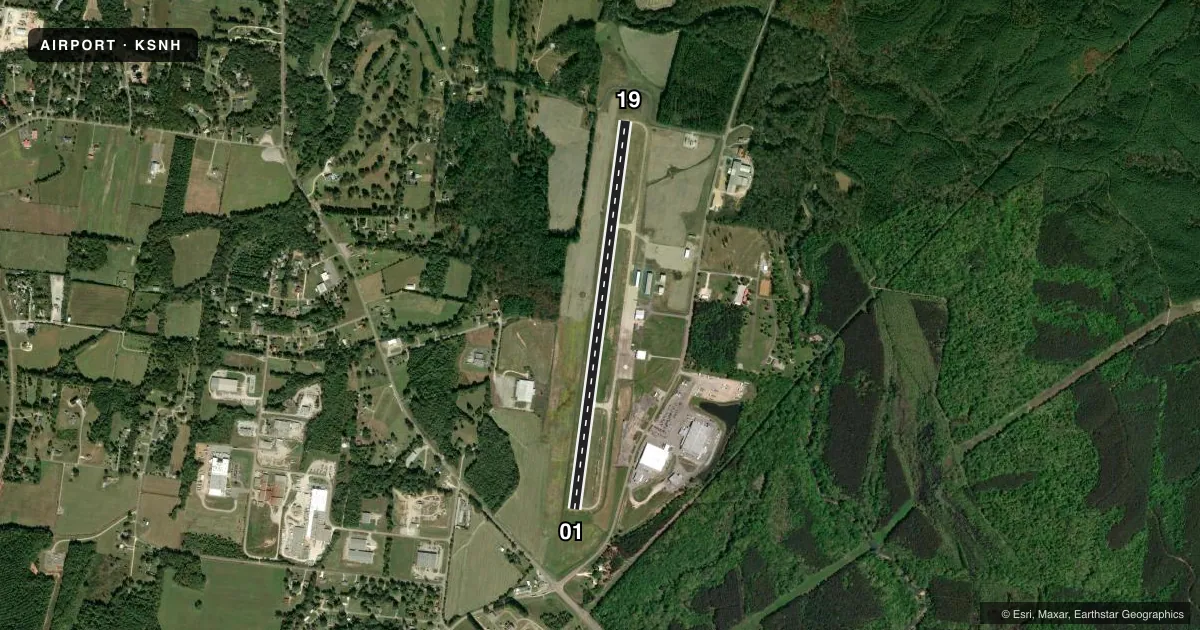
Runways & pattern
Full pagePattern entry · RWY 01
LEFT TRAFFICRunway end performance
| End | TORA | TODA | ASDA | LDA | VGSI | Approach lights | Obstruction |
|---|---|---|---|---|---|---|---|
| 01 | — | — | — | — | PAPI 2-box left(3°) | — | 104', trees, 2393' from thr, 580' R of cntrln, slope 21 |
| 19 | — | — | — | — | PAPI 2-box left(3°) | — | — |
Declared distances in feet. TORA = takeoff run available, TODA = takeoff distance, ASDA = accelerate-stop, LDA = landing distance.
Airport sketch
Runways drawn to scale from FAA survey coordinates, rendered over satellite imagery. Not for navigation.
Approaches & charts
Services on the field
Fuel grades, oxygen, maintenance, ramp storage and lighting — as declared to the FAA by the airport operator.
Fuel & services
- Fuel
- 100LLA+
- Airframe repair
- Major
- Power plant repair
- Major
- Other services
- AVNCS
Ramp & ground
- Transient storage
- Tie-down
- Hangar
- Landing fee
- No fee published
- Customs
- Not available
- Lighting schedule
- SEE RMK
- Beacon schedule
- SS-SR
- Beacon
- White / Green (civil land)(WG)
- Wind indicator
- Lighted
- Segmented circle
- Yes
Fuel & FBOs
Cheapest 100LL and Jet A on the field and nearby. Always confirm with the FBO before taxi.
Airport notes
Surface conditions, obstructions, local procedures, lighting outages and other notes published with each FAA cycle.
General notes
- FOR CD CTC MEMPHIS ARTCC AT 901-368-8453/8449.
Lighting notes
- REIL RWY 01 & 19 OPR SS-SR; ACTVT MIRL RWY 01/19 - CTAF. PAPI RWY 01 & 19 OPR CONSLY.
Other notes
- 1AFT HR - 731-727-7021 OR 731-607-1940; UNATNDD THANKSGIVING & CHRISTMAS.
- MANAGERKSNHAIRPORT@GMAIL.COM
VFR map & nearby airports
VFR sectional. Tap any ICAO chip to open that airport.
Key facts · KSNH
Answer card- ICAO
- KSNH
- Name
- SAVANNAH-HARDIN COUNTY
- Location
- SAVANNAH, TENNESSEE
- Elevation
- 472.7 ft MSL
- Traffic pattern altitude
- 1,472.7 ft MSL (1,000 AGL)
- Control tower
- Non-towered (use CTAF)
- Total runways
- 1
- Longest runway
- 01/19 · 5,002 ft
- Published ILS approaches
- 0
- Published frequencies
- 1
- Magnetic variation
- 1°
- Current flight rules
- VFR
- Current wind
- 070° at 11 kt
- Favored runway now
- RWY 01
Savannah-Hardin County Airport sits in Savannah, Tennessee. The field elevation is 472.7 ft MSL. It has one runway, 01/19, which is 5,002 ft long and paved with concrete. There is no control tower. CTAF is 122.8.
No ILS approaches are published here. The runway lighting setup is straightforward for night work. Runway end identifier lights for 01 and 19 run from sunset to sunrise. Medium intensity runway lights on 01/19 are activated by CTAF. Precision approach path indicators are listed for both runway ends and operate continuously.
The published pattern altitude is not given in the facts. For light piston aircraft, use the standard 1,000 ft AGL unless the current Chart Supplement says otherwise. The airport manager can be reached by email. After hours contact numbers are published as well. The airport is unattended on Thanksgiving and Christmas.
Savannah-Hardin County Airport has one on-field FBO. Savannah-Hardin County Airport carries 100LL and Jet A with Prist. If you need clearance delivery, Memphis ARTCC contact numbers are published in the remarks. For any current procedure, noise item, or operational change, verify with the current FAA Chart Supplement or call the airport operator before departure.