METAR & TAF KAPT
KAPT does not publish a METAR.
Showing the nearest reporting station: KCHA (LOVELL FLD) · 18.8 NM away. Conditions at KAPT may differ.
METAR · KCHA
Observed 23:53Z
KCHA 232353Z COR 36009KT 10SM FEW040 FEW250 26/16 A3011 RMK AO2 SLP187 T02560156 10267 20233 55000
- Wind
- 360° @ 9 kt
- Visibility
- 10 SM
- Temp / Dew
- 26°C / 16°C
- Altimeter
- 30.11 inHg
- Clouds
- FEW
- Density alt
- 1,879 ft
- Ceiling
- Unlimited
- Rules
- VFR
Airport info & contacts
Manager on record, flight service, ARTCC, attendance schedule and pattern altitude — published by the FAA and refreshed every 28 days.
Location
- From city
- 4 NM SE
- VFR sectional
- ATLANTA
- ARTCC
- ZTL · ATLANTA
- NOTAM facility
- BNA (NOTAM-D)
Airport manager
- Name
- WILLIAM NEAL
- Phone
- 423-432-6627
- Address
- 300 AIRPORT RD, JASPER TN 37347
Flight service · Hours
- FSS BNA
- NASHVILLE1-800-WX-BRIEF
- Attendance
- MON-FRI · 0800-1700
- SAT · 0800-1700
- SUN · 1200-1700
Frequencies
Tap any row to copy the frequency to your clipboard.
Runways & pattern
Full pagePattern entry · RWY 04
LEFT TRAFFICRunway end performance
| End | TORA | TODA | ASDA | LDA | VGSI | Approach lights | Obstruction |
|---|---|---|---|---|---|---|---|
| 04 | — | — | — | — | PAPI 2-box left(3.5°) | — | — |
| 22 | — | — | — | — | PAPI 2-box left(3.5°) | — | 41', tree, 895' from thr, 188' R of cntrln, slope 16 |
Declared distances in feet. TORA = takeoff run available, TODA = takeoff distance, ASDA = accelerate-stop, LDA = landing distance.
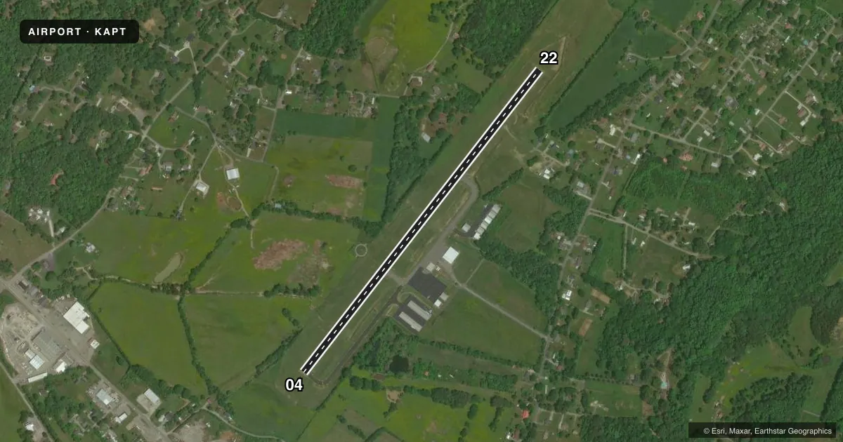
Airport sketch
Runways drawn to scale from FAA survey coordinates, rendered over satellite imagery. Not for navigation.
Approaches & charts
Services on the field
Fuel grades, oxygen, maintenance, ramp storage and lighting — as declared to the FAA by the airport operator.
Fuel & services
- Fuel
- 100LLA+MOGAS
- Other services
- PAJA
Ramp & ground
- Transient storage
- Tie-down
- Hangar
- Landing fee
- No fee published
- Customs
- Not available
- Lighting schedule
- SEE RMK
- Beacon schedule
- SS-SR
- Beacon
- White / Green (civil land)(WG)
- Wind indicator
- Yes
- Segmented circle
- Yes
Fuel & FBOs
Cheapest 100LL and Jet A on the field and nearby. Always confirm with the FBO before taxi.
Airport notes
Surface conditions, obstructions, local procedures, lighting outages and other notes published with each FAA cycle.
General notes
- ULTRALIGHT ACT & DEER ON & INVOF ARPT.
- FOR CD CTC CHATTANOOGA APCH AT 423-855-6478. WHEN APCH CLSD FOR CD CTC MEMPHIS ARTCC AT 901-368-8453/8449.
Lighting notes
- ACTVT REIL RWY 04 & 22; PAPI RWY 4 & 22; MIRL RWY 4/22 - CTAF.
Fuel notes
- MOGAS87 OCTANE
Other notes
- 2CLSD FED HOL.
- PAJADSGND LNDG AREA IN GRASS AT CESSNA LN ONLY.
VFR map & nearby airports
VFR sectional. Tap any ICAO chip to open that airport.
Key facts · KAPT
Answer card- ICAO
- KAPT
- Name
- MARION COUNTY/BROWN FLD
- Location
- JASPER, TENNESSEE
- Elevation
- 641.2 ft MSL
- Traffic pattern altitude
- 1,641.2 ft MSL (1,000 AGL)
- Control tower
- Non-towered (use CTAF)
- Total runways
- 1
- Longest runway
- 04/22 · 3,498 ft
- Published ILS approaches
- 0
- Published frequencies
- 4
- Magnetic variation
- 2°
- Current flight rules
- VFR
- Current wind
- 360° at 9 kt
- Favored runway now
- RWY 04
Marion County/Brown Fld is in Jasper, Tennessee. The field elevation is 641.2 ft MSL. It has one runway. Runway 04/22 is 3,498 ft long with asphalt pavement. There is no control tower. CTAF and UNICOM are both 122.8. Approach and departure service is through Chattanooga on 119.2 or 323.075.
No ILS approaches are published here. The pattern altitude is not published. Use the standard 1,000 ft AGL pattern for light piston traffic unless the current Chart Supplement says otherwise. The published remarks also note medium intensity runway lights on 04/22. Runway end identifier lights are active on both ends. PAPI is installed on both runway ends.
Marion County Airport is the on-field FBO. It carries 100LL, Jet A, Prist and MOGAS. The remarks also say MOGAS is 87 octane. For clearance delivery, contact Chattanooga Approach at 423-855-6478. If Chattanooga Approach is closed, use Memphis ARTCC at the numbers listed in the Chart Supplement. The airport is closed on federal holidays. Expect some extra traffic awareness here too. Ultralights operate on the field. Deer are also reported on and near the airport. If you are planning a first stop here, brief the runway lighting. Watch for wildlife. Verify current procedures before arrival.