METAR & TAF KLGC
Current METAR
Observed 07:15Z
KLGC 270715Z AUTO 00000KT 2 1/2SM BR CLR 25/24 A2994 RMK AO2
- Wind
- 000° @ 0 kt
- Visibility
- 0.5 SM
- Temp / Dew
- 25°C / 24°C
- Altimeter
- 29.94 inHg
- Clouds
- CLR
- Density alt
- 2,035 ft
- Ceiling
- Unlimited
- Rules
- LIFR
Airport info & contacts
Manager on record, flight service, ARTCC, attendance schedule and pattern altitude — published by the FAA and refreshed every 28 days.
Location
- From city
- 3 NM SW
- VFR sectional
- ATLANTA
- Pattern altitude
- 1,007 ft AGL · 1,701 ft MSL
- ARTCC
- ZTL · ATLANTA
- NOTAM facility
- LGC (NOTAM-D)
Airport manager
- Name
- LANDON MILES
- Phone
- 706-616-1553
- Address
- 200 AIRPORT PARKWAY, LAGRANGE GA 30240
Flight service · Hours
- FSS MCN
- MACON1-800-WX-BRIEF
- Attendance
- MON-FRI · 0800-1800
- SAT-SUN · 0900-1700
Frequencies
Tap any row to copy the frequency to your clipboard.
Runways & pattern
Full pagePattern entry · RWY 13
LEFT TRAFFIC| Runway | Heading (°M) | Length | Surface | Traffic |
|---|---|---|---|---|
| 13/31 | 123° / 302° | 6,499 ft | ASPH | Standard L |
| 03/21 | 20° / 200° | 5,000 ft | ASPH | Standard L |
Runway end performance
| End | TORA | TODA | ASDA | LDA | VGSI | Approach lights | Obstruction |
|---|---|---|---|---|---|---|---|
| 13 | — | — | — | — | PAPI 4-box left(3°) | — | 123', trees, 2414' from thr, 675' R of cntrln, slope 18 |
| 31 | — | — | — | — | PAPI 4-box right(3°) | MALSR | 143', trees, 5634' from thr, 592' R of cntrln, slope 38 |
| 03 | — | — | — | — | — | — | 33', trees, 282' from thr, 261' R of cntrln, slope 2 |
| 21 | — | — | — | — | — | — | 41', pole, 845' from thr, 149' R of cntrln, slope 15 |
Declared distances in feet. TORA = takeoff run available, TODA = takeoff distance, ASDA = accelerate-stop, LDA = landing distance.
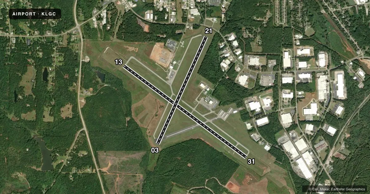
Airport sketch
Runways drawn to scale from FAA survey coordinates, rendered over satellite imagery. Not for navigation.
Approaches & charts
ILS · 1
Services on the field
Fuel grades, oxygen, maintenance, ramp storage and lighting — as declared to the FAA by the airport operator.
Fuel & services
- Fuel
- 100LLA+
- Oxygen (bottled)
- Low pressure
- Oxygen (bulk)
- Not available
- Airframe repair
- Major
- Power plant repair
- Major
- Other services
- AMB,INSTR,RNTL
Ramp & ground
- Transient storage
- Tie-down
- Landing fee
- No fee published
- Customs
- Not available
- Lighting schedule
- SEE RMK
- Beacon schedule
- SS-SR
- Beacon
- White / Green (civil land)(WG)
- Wind indicator
- Lighted
- Segmented circle
- Yes
Fuel & FBOs
Cheapest 100LL and Jet A on the field and nearby. Always confirm with the FBO before taxi.
Airport notes
Surface conditions, obstructions, local procedures, lighting outages and other notes published with each FAA cycle.
General notes
- DEER ON & INVOF ARPT.
Lighting notes
- ACTVT MALSR RWY 31; HIRL RWY 13/31; TWY LGTS - CTAF.
Fuel notes
- 100LLFUEL 24 HR CREDIT CARD SVC AVBL.
- A+FOR SVC AFT HRS CALL 706-616-1553
VFR map & nearby airports
VFR sectional. Tap any ICAO chip to open that airport.
Key facts · KLGC
Answer card- ICAO
- KLGC
- Name
- LAGRANGE/CALLAWAY
- Location
- LAGRANGE, GEORGIA
- Elevation
- 693.6 ft MSL
- Traffic pattern altitude
- 1,700.6 ft MSL (1,007 AGL)
- Control tower
- Non-towered (use CTAF)
- Total runways
- 2
- Longest runway
- 13/31 · 6,499 ft
- Published ILS approaches
- 1
- Published frequencies
- 5
- Magnetic variation
- 4°
- Current flight rules
- LIFR
- Current wind
- 000° at 0 kt
- Favored runway now
- –
LaGrange/Callaway Airport sits in LaGrange, Georgia. The field elevation is 693.6 ft MSL. It has two asphalt runways. The longest is runway 13/31 at 6,499 ft. There is no control tower, so expect CTAF traffic and self-announce discipline. Pattern altitude is 1,700.6 ft MSL. That is 1,007 ft AGL.
Runway 31 has the published ILS approach. Runway 31 also has medium intensity approach lighting with runway alignment indicator lights. High intensity runway lights are on runways 13 and 31. Taxiway lights are controlled on CTAF, so brief the lighting setup before night work.
The on-field FBO is LaGrange-Callaway Airport. It carries AVGAS 100LL and JET-A PRIST. Fuel is available 24 hours with credit card service. Deer are on and in the vicinity of the airport, so use extra caution on taxi, takeoff and landing. For current noise, curfew, or any local operating notes not listed here, check the current FAA Chart Supplement before you go. The airport sits in the Atlanta area approach environment. Expect to work with Atlanta Approach or Departure on the listed frequencies when you are in the air.