METAR & TAF KCKF
Current METAR
Observed 04:35Z
KCKF 270435Z AUTO 28003KT 10SM CLR 26/26 A2995 RMK AO2 LTG DSNT NE AND E T02620258
- Wind
- 280° @ 3 kt
- Visibility
- 10 SM
- Temp / Dew
- 26°C / 26°C
- Altimeter
- 29.95 inHg
- Clouds
- CLR
- Density alt
- 1,667 ft
- Ceiling
- Unlimited
- Rules
- VFR
Airport info & contacts
Manager on record, flight service, ARTCC, attendance schedule and pattern altitude — published by the FAA and refreshed every 28 days.
Location
- From city
- 2 NM NE
- VFR sectional
- JACKSONVILLE
- ARTCC
- ZJX · JACKSONVILLE
- NOTAM facility
- MCN (NOTAM-D)
Airport manager
- Name
- SHERRIE LEVERETT
- Phone
- 229-276-2673
- Address
- 210 S 7TH STREET, CORDELE GA 31015
Flight service · Hours
- FSS MCN
- MACON1-800-WX-BRIEF
- Attendance
- MON-FRI · 0800-1700
Frequencies
Tap any row to copy the frequency to your clipboard.
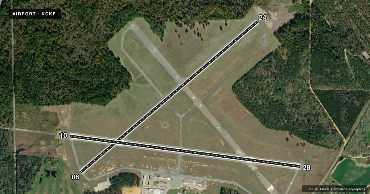
Runways & pattern
Full pagePattern entry · RWY 28
RIGHT TRAFFIC| Runway | Heading (°M) | Length | Surface | Traffic |
|---|---|---|---|---|
| 06/24 | 44° / 224° | 5,008 ft | ASPH | 24 R |
| 10/28Favored | 92° / 272° | 5,001 ft | ASPH | 28 R |
Runway end performance
| End | TORA | TODA | ASDA | LDA | VGSI | Approach lights | Obstruction |
|---|---|---|---|---|---|---|---|
| 06 | — | — | — | — | — | — | 27', tree, 490' from thr, 236' R of cntrln, slope 10 |
| 24 | — | — | — | — | — | — | 17', trees, 414' from thr, 271' R of cntrln, slope 12 |
| 10 | — | — | — | — | PAPI 2-box left(3°) | ODALS | 92', trees, 2325' from thr, 438' R of cntrln, slope 23 |
| 28 | — | — | — | — | PAPI 2-box left(3°) | — | 39', trees, 600' from thr, 278' R of cntrln, slope 10 |
Declared distances in feet. TORA = takeoff run available, TODA = takeoff distance, ASDA = accelerate-stop, LDA = landing distance.
Airport sketch
Runways drawn to scale from FAA survey coordinates, rendered over satellite imagery. Not for navigation.
Approaches & charts
ILS · 1
Services on the field
Fuel grades, oxygen, maintenance, ramp storage and lighting — as declared to the FAA by the airport operator.
Fuel & services
- Fuel
- 100LLA+
- Oxygen (bottled)
- Not available
- Oxygen (bulk)
- Not available
- Airframe repair
- Major
- Power plant repair
- Major
- Other services
- AGRI,GLD
Ramp & ground
- Transient storage
- Tie-down
- Hangar
- Landing fee
- No fee published
- Customs
- Not available
- Lighting schedule
- SEE RMK
- Beacon schedule
- SS-SR
- Beacon
- White / Green (civil land)(WG)
- Wind indicator
- Yes
- Segmented circle
- Yes
Fuel & FBOs
Cheapest 100LL and Jet A on the field and nearby. Always confirm with the FBO before taxi.
Airport notes
Surface conditions, obstructions, local procedures, lighting outages and other notes published with each FAA cycle.
General notes
- FOR CD CTC JACKSONVILLE ARTCC AT 904-845-1592.
Lighting notes
- MIRL RWY 10/28 & PAPI RWY 10 & 28 PRESET ON LOW INTST DUSK-2200; TO INCR INTST & ACTVT AFT 2200 - CTAF. ACTVT ODALS RWY 10 & REIL RWY 10 & 28 - CTAF.
Other notes
- EXISTED PRIOR TO 1959.
VFR map & nearby airports
VFR sectional. Tap any ICAO chip to open that airport.
Key facts · KCKF
Answer card- ICAO
- KCKF
- Name
- CRISP COUNTY-CORDELE
- Location
- CORDELE, GEORGIA
- Elevation
- 309.6 ft MSL
- Traffic pattern altitude
- 1,309.6 ft MSL (1,000 AGL)
- Control tower
- Non-towered (use CTAF)
- Total runways
- 2
- Longest runway
- 06/24 · 5,008 ft
- Published ILS approaches
- 1
- Published frequencies
- 2
- Magnetic variation
- 6°
- Current flight rules
- VFR
- Current wind
- 280° at 3 kt
- Favored runway now
- RWY 28
Crisp County-Cordele Airport sits in Cordele, Georgia. The field elevation is 309.6 ft MSL. It has two asphalt runways. The longest is Runway 06/24 at 5,008 ft. There is no control tower, so plan for non-towered traffic and standard CTAF calls on 123.05.
The airport has one ILS approach to Runway 10. Pattern altitude is not published in the facts, so use the standard 1,000 ft AGL for light piston traffic unless the current Chart Supplement says otherwise. Richter Aviation is on the field. It carries 100LL and Jet A Prist. Call (229) 273-3124 for current fuel and service details.
Published remarks matter here. Clearance delivery goes through Jacksonville ARTCC at 904-845-1592. Runway 10/28 has medium intensity lighting. The PAPI on Runways 10 and 28 starts at low intensity from dusk to 2200. After 2200, use the CTAF to increase intensity and to activate the lights. The approach lighting system for Runway 10 and the runway end identifier lights on Runways 10 and 28 also come on via CTAF. For a first-time arrival, watch the lighting setup and confirm the runway you want. If you need current noise, curfew, or airspace details, check the current FAA Chart Supplement before you go.