METAR & TAF X60
Current METAR
Observed 18:35Z
KX60 271835Z AUTO 36010G15KT 10SM SCT041 SCT047 34/24 A2987 RMK AO2 LTG DSNT S AND SW
- Wind
- 360° @ 10G15 kt
- Visibility
- 10 SM
- Temp / Dew
- 34°C / 24°C
- Altimeter
- 29.87 inHg
- Clouds
- SCT
- Density alt
- 2,436 ft
- Ceiling
- Unlimited
- Rules
- VFR
Airport info & contacts
Manager on record, flight service, ARTCC, attendance schedule and pattern altitude — published by the FAA and refreshed every 28 days.
Location
- From city
- 2 NM SW
- VFR sectional
- JACKSONVILLE
- ARTCC
- ZJX · JACKSONVILLE
- NOTAM facility
- GNV (NOTAM-D)
Airport manager
- Name
- BENTON STEGALL
- Phone
- 352-266-5792
- Address
- 1891 SW 18TH ST, WILLISTON FL 32696-0160
Flight service · Hours
- FSS GNV
- GAINESVILLE1-800-WX-BRIEF
- Attendance
- 0730-1730
Frequencies
Tap any row to copy the frequency to your clipboard.
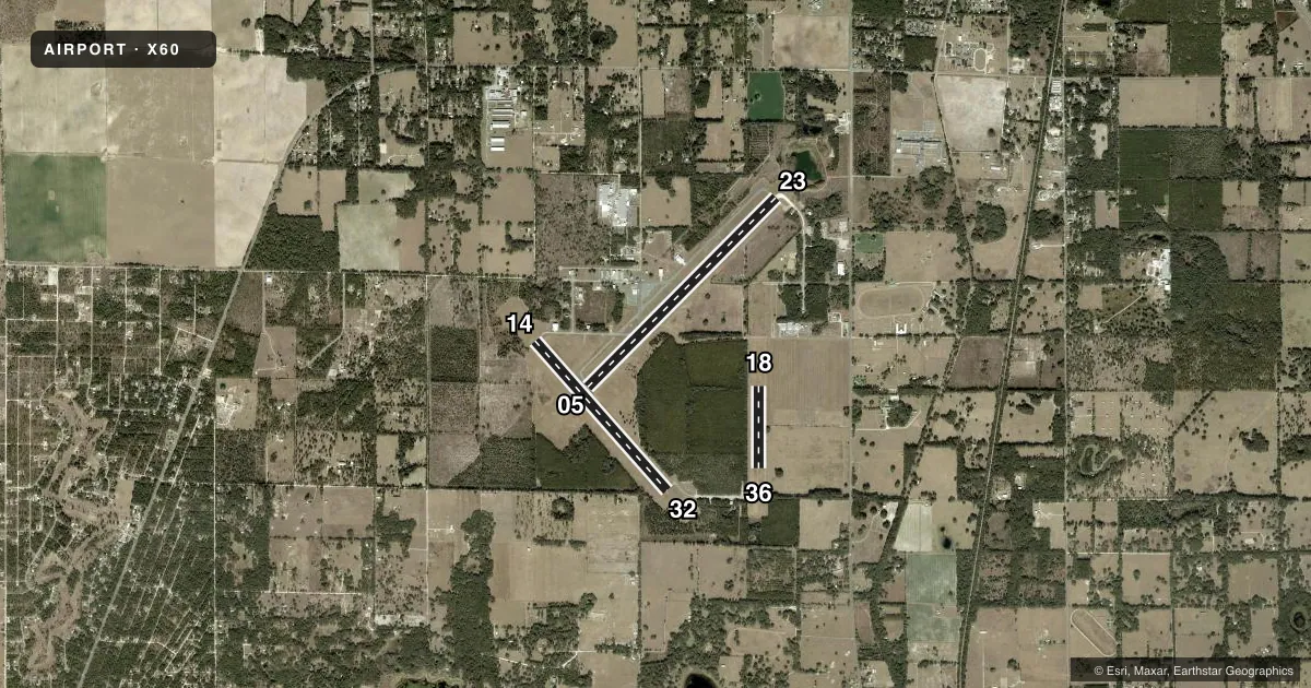
Runways & pattern
Full pagePattern entry · RWY 36
LEFT TRAFFIC| Runway | Heading (°M) | Length | Surface | Traffic |
|---|---|---|---|---|
| 05/23 | 41° / 221° | 6,669 ft | CONC | Standard L |
| 14/32 | 134° / 314° | 4,979 ft | ASPH | Standard L |
| 18/36Favored | 176° / 356° | 2,051 ft | TURF | 18 R |
Runway end performance
| End | TORA | TODA | ASDA | LDA | VGSI | Approach lights | Obstruction |
|---|---|---|---|---|---|---|---|
| 05 | — | — | — | — | PAPI 2-box left(3°) | — | 46', trees, 1785' from thr, 180' R of cntrln, slope 34 |
| 23 | — | — | — | — | PAPI 2-box left(3°) | — | 48', trees, 1920' from thr, 240' R of cntrln, slope 35 |
| 14 | — | — | — | — | PAPI 2-box left(3°) | — | 81', trees, 1885' from thr, 120' R of cntrln, slope 20 |
| 32 | — | — | — | — | PAPI 2-box left(3°) | — | 50', trees, 1005' from thr, 125' R of cntrln, slope 16 |
| 18 | — | — | — | — | — | — | 88', trees, 3050' from thr, 125' R of cntrln, slope 34 |
| 36 | — | — | — | — | — | — | 66', trees, 1505' from thr, 145' R of cntrln, slope 22 |
Declared distances in feet. TORA = takeoff run available, TODA = takeoff distance, ASDA = accelerate-stop, LDA = landing distance.
Airport sketch
Runways drawn to scale from FAA survey coordinates, rendered over satellite imagery. Not for navigation.
Approaches & charts
Services on the field
Fuel grades, oxygen, maintenance, ramp storage and lighting — as declared to the FAA by the airport operator.
Fuel & services
- Fuel
- 100LLA
- Oxygen (bottled)
- Not available
- Oxygen (bulk)
- Not available
- Airframe repair
- Major
- Power plant repair
- Major
- Other services
- CHTR,INSTR,RNTL,SALES
Ramp & ground
- Transient storage
- Tie-down
- Hangar
- Landing fee
- No fee published
- Customs
- Not available
- Lighting schedule
- SEE RMK
- Beacon schedule
- SS-SR
- Beacon
- White / Green (civil land)(WG)
- Wind indicator
- Lighted
- Segmented circle
- Yes
Fuel & FBOs
Cheapest 100LL and Jet A on the field and nearby. Always confirm with the FBO before taxi.
Airport notes
Surface conditions, obstructions, local procedures, lighting outages and other notes published with each FAA cycle.
General notes
- INFIELD BERM & TREES BLOCKING VISION BTN RWY ENDS.
- FOR CD CTC JACKSONVILLE APCH AT 904-741-0284.
Lighting notes
- ACTVT REIL RWY 05, 14, 23 & 32; HIRL RWY 05/23; MIRL RWY 14/32. - CTAF.
Approach & departure obstructions
- 18RWY 18/36 MARKED WITH W TIRES.
Other notes
- EXISTED PRIOR TO 1959.
VFR map & nearby airports
VFR sectional. Tap any ICAO chip to open that airport.
Key facts · X60
Answer card- ICAO
- X60
- Name
- WILLISTON RGNL
- Location
- WILLISTON, FLORIDA
- Elevation
- 75.6 ft MSL
- Traffic pattern altitude
- 1,075.6 ft MSL (1,000 AGL)
- Control tower
- Non-towered (use CTAF)
- Total runways
- 3
- Longest runway
- 05/23 · 6,669 ft
- Published ILS approaches
- 0
- Published frequencies
- 4
- Magnetic variation
- 4°
- Current flight rules
- VFR
- Current wind
- 360° at 10 kt
- Favored runway now
- RWY 36
Williston Rgnl sits in Williston, Florida at 75.6 ft MSL. It has three runways. The longest is 05/23 at 6,669 ft. The field is non-towered. Use CTAF 122.975 for local traffic. Jacksonville Approach handles clearance delivery and approach or departure services. No ILS approaches are published here. The pattern altitude is not published, so use the standard 1,000 ft AGL for light piston operations unless current local guidance says otherwise.
The on-field FBO is Williston Municipal Airport. It carries 100LL and Jet A. Call them at (352) 528-4900 before arrival if you need current service details. Published remarks note that an infield berm and trees block the view between runway ends. That matters on the ground and in the pattern. Runway end identifier lights are installed on 05, 14, 23 and 32. High intensity lights are on 05/23. Medium intensity lights are on 14/32. Runway 18/36 is a turf strip marked with white tires.
For a first-time arrival, plan for a non-towered field with mixed pavement and turf options. Keep the runway-end visibility issue in mind. If you need a clearance, contact Jacksonville Approach at 904-741-0284 before departure.