METAR & TAF KCGC
Current METAR
Observed 05:15Z
KCGC 270515Z AUTO 25005KT 10SM SCT018 SCT024 SCT029 29/26 A2995 RMK AO2
- Wind
- 250° @ 5 kt
- Visibility
- 10 SM
- Temp / Dew
- 29°C / 26°C
- Altimeter
- 29.95 inHg
- Clouds
- SCT
- Density alt
- 1,654 ft
- Ceiling
- Unlimited
- Rules
- VFR
Airport info & contacts
Manager on record, flight service, ARTCC, attendance schedule and pattern altitude — published by the FAA and refreshed every 28 days.
Location
- From city
- 3 NM SE
- VFR sectional
- JACKSONVILLE
- ARTCC
- ZJX · JACKSONVILLE
- NOTAM facility
- CGC (NOTAM-D)
Airport manager
- Name
- TODD REGAN
- Phone
- 352-527-5488
- Address
- 3600 W SOVEREIGN PATH, STE 241, LECANTO FL 34461
Flight service · Hours
- FSS PIE
- SAINT PETERSBURG1-800-WX-BRIEF
- Attendance
- 0800-1800
Frequencies
Tap any row to copy the frequency to your clipboard.
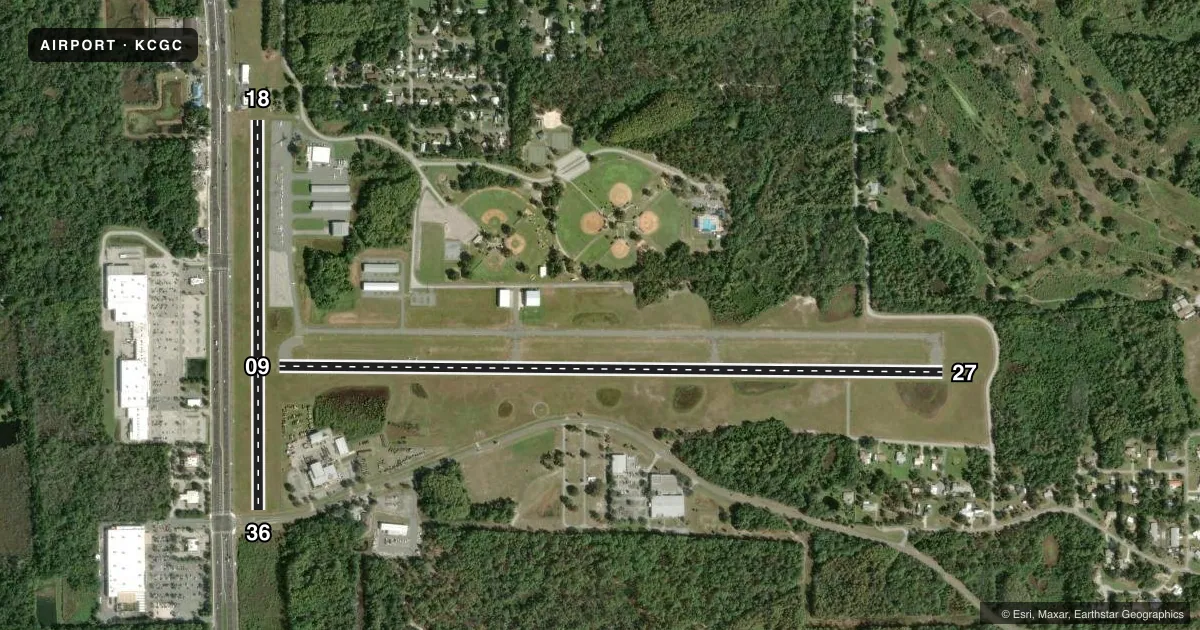
Runways & pattern
Full pagePattern entry · RWY 27
LEFT TRAFFIC| Runway | Heading (°M) | Length | Surface | Traffic |
|---|---|---|---|---|
| 09/27Favored | 86° / 266° | 4,557 ft | ASPH | Standard L |
| 18/36 | 175° / 355° | 2,666 ft | TURF | Standard L |
Runway end performance
| End | TORA | TODA | ASDA | LDA | VGSI | Approach lights | Obstruction |
|---|---|---|---|---|---|---|---|
| 09 | — | — | — | — | PAPI 4-box left(3°) | — | 18', road, 350' from thr, 0' R of cntrln, slope 8 |
| 27 | — | — | — | — | PAPI 2-box right(3°) | — | 18', brush, 405' from thr, 185' R of cntrln, slope 11 |
| 18 | — | — | — | — | — | — | 15', bldg, 104' from thr, 85' R of cntrln, slope 6 |
| 36 | — | — | — | — | — | — | 7', fence, 15' from thr, 0' R of cntrln, slope 2 |
Declared distances in feet. TORA = takeoff run available, TODA = takeoff distance, ASDA = accelerate-stop, LDA = landing distance.
Airport sketch
Runways drawn to scale from FAA survey coordinates, rendered over satellite imagery. Not for navigation.
Approaches & charts
Services on the field
Fuel grades, oxygen, maintenance, ramp storage and lighting — as declared to the FAA by the airport operator.
Fuel & services
- Fuel
- 100LLA
- Oxygen (bottled)
- Not available
- Oxygen (bulk)
- Not available
- Airframe repair
- Minor
- Power plant repair
- Minor
- Other services
- CHTR,INSTR,RNTL,SALES
Ramp & ground
- Transient storage
- Tie-down
- Landing fee
- No fee published
- Customs
- Not available
- Lighting schedule
- SEE RMK
- Beacon schedule
- SS-SR
- Beacon
- White / Green (civil land)(WG)
- Wind indicator
- Lighted
Fuel & FBOs
Cheapest 100LL and Jet A on the field and nearby. Always confirm with the FBO before taxi.
Airport notes
Surface conditions, obstructions, local procedures, lighting outages and other notes published with each FAA cycle.
General notes
- GLIDER OPNS WITHIN 25 NM.
- BLDG 30-85 FT W OF AER RWY 18 100 FT R OF CNTRLN.
- AEROBATIC ACTVT ALONG N SIDE OF RWY 09/27 & 4 NM SW OF ARPT. CTC UNICOM FOR TFC INFO, AND NOTAMS OR FSS FOR SPECIFIC TIMES.
- RWY 09/27 TREES SOUTH SIDE OF RWY IN PRIMARY & TRANSITION SFC.
- FOR CD CTC JACKSONVILLE APCH AT 904-741-0284.
- STANDING WATER INSIDE RWY SAFETY AREAS FOR ALL RWYS AFTER HVY RNFL.
Lighting notes
- ACTVT REIL RWY 09, 27; MIRL RWY 09/27 - CTAF.
Approach & departure obstructions
- 1818/36 DTHR MKD WITH GREEN PIPES.
- 1818/36 MKD WITH WHITE PIPES EVERY 200 FT.
- 09RWY 09 APRCH RATIO 22:1 TO DTHR.
- 18RWY 18 APCH RATIO 20:1 TO DTHR.
- 36RWY 36 APCH RATIO 22:1 TO DTHR.
Other notes
- VFR, PRIVATE USE ONLY.
- MANAGERAIRPORT PHYSICAL ADDRESS: 718 NORTH LINDBERGH DRIVE, CRYSTAL RIVER, FL 34429 352-795-6868 FAX: 352-795-1730
- OWNERCONTACT PERSON: TODD REGAN 3600 WEST SOVEREIGN PATH, SUITE 241, LACANTO FL, 34461 352-527-5247 FAX; 352-527-5482.
- 18/36RWY 18/36 SOFT & WET AFT RAIN.
VFR map & nearby airports
VFR sectional. Tap any ICAO chip to open that airport.
Key facts · KCGC
Answer card- ICAO
- KCGC
- Name
- CRYSTAL RIVER/DAVIS FLD
- Location
- CRYSTAL RIVER, FLORIDA
- Elevation
- 8.9 ft MSL
- Traffic pattern altitude
- 1,008.9 ft MSL (1,000 AGL)
- Control tower
- Non-towered (use CTAF)
- Total runways
- 2
- Longest runway
- 09/27 · 4,557 ft
- Published ILS approaches
- 0
- Published frequencies
- 4
- Magnetic variation
- 5°
- Current flight rules
- VFR
- Current wind
- 250° at 5 kt
- Favored runway now
- RWY 27
KCGC is in Crystal River, Florida. The field elevation is 8.9 ft MSL. It has 2 runways. The longest is 4,557 ft on runway 09/27. This is a non-towered airport, so use CTAF 122.725 for traffic calls and runway lighting control on 09 and 27. No ILS approaches are published here, so plan with current charts and weather in mind before you go.
Pattern altitude is not published. Use 1,000 ft AGL for light piston traffic unless the current FAA Chart Supplement says otherwise. Crystal Aero Group is on the field. It carries 100LL and Jet A. If you need fuel or ramp details, call them at (352) 795-6868 before departure.
A few runway notes matter here. Runway 09 has obstacle clearance notes on the approach. Runways 18 and 36 have displaced thresholds marked with green pipes. Runway 18/36 is soft and wet after rain. Standing water can also be present inside the runway safety areas after heavy rainfall. There is aerobatic activity along the north side of runway 09/27 and 4 NM southwest of the airport. Glider operations also occur within 25 NM. For clearance delivery, Jacksonville Approach handles it. Check the current FAA Chart Supplement for any noise or operational changes before flying in.