METAR & TAF KINF
Current METAR
Observed 12:55Z
KINF 271255Z AUTO 00000KT 5SM VCTS BR SCT020 SCT075 OVC100 25/25 A2994 RMK AO2 LTG DSNT S THRU W
- Wind
- 000° @ 0 kt
- Visibility
- 5 SM
- Temp / Dew
- 25°C / 25°C
- Altimeter
- 29.94 inHg
- Clouds
- OVC
- Density alt
- 1,255 ft
- Ceiling
- 10,000 ft AGL
- Rules
- MVFR
Airport info & contacts
Manager on record, flight service, ARTCC, attendance schedule and pattern altitude — published by the FAA and refreshed every 28 days.
Location
- From city
- 2 NM SE
- VFR sectional
- JACKSONVILLE
- ARTCC
- ZJX · JACKSONVILLE
- NOTAM facility
- PIE (NOTAM-D)
Airport manager
- Name
- TODD REGAN
- Phone
- 352-527-5488
- Address
- 3600 W SOVEREIGN PATH, SUITE 210, INVERNESS FL 34450
Flight service · Hours
- FSS PIE
- SAINT PETERSBURG1-800-WX-BRIEF
- Attendance
- 0600-2000
Frequencies
Tap any row to copy the frequency to your clipboard.
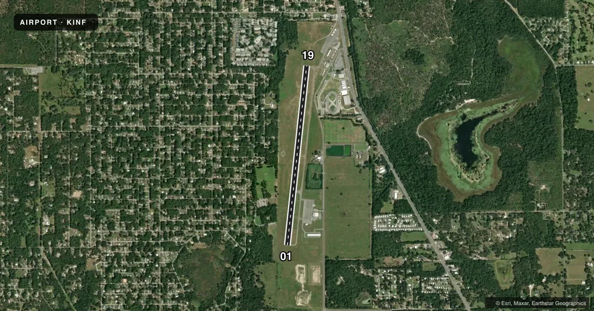
Runways & pattern
Full pagePattern entry · RWY 01
RIGHT TRAFFICRunway end performance
| End | TORA | TODA | ASDA | LDA | VGSI | Approach lights | Obstruction |
|---|---|---|---|---|---|---|---|
| 01 | — | — | — | — | PAPI 4-box left(3.5°) | — | 43', tree, 900' from thr, 200' R of cntrln, slope 16 |
| 19 | — | — | — | — | PAPI 4-box left(3.5°) | — | 98', trees, 1665' from thr, 315' R of cntrln, slope 14 |
Declared distances in feet. TORA = takeoff run available, TODA = takeoff distance, ASDA = accelerate-stop, LDA = landing distance.
Airport sketch
Runways drawn to scale from FAA survey coordinates, rendered over satellite imagery. Not for navigation.
Approaches & charts
Services on the field
Fuel grades, oxygen, maintenance, ramp storage and lighting — as declared to the FAA by the airport operator.
Fuel & services
- Fuel
- 100LLA+
- Oxygen (bottled)
- Not available
- Oxygen (bulk)
- Not available
- Airframe repair
- Major
- Power plant repair
- Major
- Other services
- AMB,GLD,INSTR,RNTL,SALES,TOW
Ramp & ground
- Transient storage
- Tie-down
- Landing fee
- No fee published
- Customs
- Not available
- Lighting schedule
- SEE RMK
- Beacon schedule
- SS-SR
- Beacon
- White / Green (civil land)(WG)
- Wind indicator
- Lighted
Fuel & FBOs
Cheapest 100LL and Jet A on the field and nearby. Always confirm with the FBO before taxi.
Airport notes
Surface conditions, obstructions, local procedures, lighting outages and other notes published with each FAA cycle.
General notes
- RWY 19 300' AGL TOWER 5600' N OF THR 2500' R OF CL.
- FOR CD CTC JACKSONVILLE APCH AT 904-741-0284.
- UNLGTD OBSTNS IN RWY 01 APCH, TREES 89 FT TALL, 2140 FT FM AER RWY 01.
- UNLGTD OBSTNS IN RWY 19 APPCH, TREES 98 FT TALL, 1,655 FT FM AER RWY 19.
Lighting notes
- ACTVT REIL RWY 01 & 19; MIRL RWY 01/19 - CTAF.
Fuel notes
- 100LLFUEL 24 HR CREDIT CARD SVC AVBL.
Other notes
- PRVDD COORDINATION FOR THE ESTABLISHMENT OF THE PROPOSED NONFEDERAL NDB IS COORDINATED WITH ORL/ADO AND RY EXT MAY BE SUBJ TO ENVIRONMENTAL REVIEW.
VFR map & nearby airports
VFR sectional. Tap any ICAO chip to open that airport.
Key facts · KINF
Answer card- ICAO
- KINF
- Name
- INVERNESS
- Location
- INVERNESS, FLORIDA
- Elevation
- 64.5 ft MSL
- Traffic pattern altitude
- 1,064.5 ft MSL (1,000 AGL)
- Control tower
- Non-towered (use CTAF)
- Total runways
- 1
- Longest runway
- 01/19 · 5,000 ft
- Published ILS approaches
- 0
- Published frequencies
- 4
- Magnetic variation
- 5°
- Current flight rules
- MVFR
- Current wind
- 000° at 0 kt
- Favored runway now
- –
Inverness Airport (KINF) sits in Inverness, Florida at 64.5 ft MSL. It has one runway, 01/19, which is 5,000 ft long. The field is non-towered, so expect self-announce traffic on CTAF 122.725. Pattern altitude is not published. Use the standard 1,000 ft AGL pattern for light piston operations unless the current Chart Supplement says otherwise.
No ILS approaches are published here. Jacksonville Approach handles clearance delivery and approach or departure services on 118.6 and 251.15. The published remarks matter on the arrival. There is a 300 ft AGL tower 5,600 ft north of the Runway 19 threshold and 2,500 ft right of centerline. There are also unlighted trees in both approaches. Runway 19 has trees 98 ft tall about 1,655 ft from the approach end. Runway 01 has trees 89 ft tall about 2,140 ft from the approach end.
Right Rudder Aviation is on the field. It carries 100LL and Jet A. Fuel is available 24 hours with credit card service. Runway end identifier lights are on both ends. Medium intensity runway lights are on Runway 01/19 and are controlled by CTAF. If you are planning a night arrival or a heavier load, brief the runway length, the obstacle picture and the lack of published ILS before you go.