METAR & TAF X39
X39 does not publish a METAR.
Showing the nearest reporting station: KZPH (ZEPHYRHILLS MUNI) · 11.6 NM away. Conditions at X39 may differ.
METAR · KZPH
Observed 11:55Z
KZPH 271155Z AUTO 01008KT 10SM -RA SCT010 BKN019 OVC026 25/24 A2996 RMK A02 P0001 T02460243 10260 20240 60001 70001
- Wind
- 010° @ 8 kt
- Visibility
- 10 SM
- Temp / Dew
- 25°C / 24°C
- Altimeter
- 29.96 inHg
- Clouds
- OVC
- Density alt
- 1,235 ft
- Ceiling
- 1,900 ft AGL
- Rules
- MVFR
Airport info & contacts
Manager on record, flight service, ARTCC, attendance schedule and pattern altitude — published by the FAA and refreshed every 28 days.
Location
- From city
- 17 NM NE
- VFR sectional
- JACKSONVILLE
- ARTCC
- ZMA · MIAMI
- NOTAM facility
- PIE (NOTAM-D)
Airport manager
- Name
- ANGELA BRAMMER
- Phone
- 813-973-3703
- Address
- TAMPA NORTH AERO PARK, 4241 BIRDSONG BLVD, LUTZ FL 33559
Flight service · Hours
- FSS PIE
- SAINT PETERSBURG1-800-WX-BRIEF
- Attendance
- 0800-1700
Frequencies
Tap any row to copy the frequency to your clipboard.
Runways & pattern
Full pagePattern entry · RWY 32
LEFT TRAFFICRunway end performance
| End | TORA | TODA | ASDA | LDA | VGSI | Approach lights | Obstruction |
|---|---|---|---|---|---|---|---|
| 14 | — | — | — | — | — | — | 15', road, 330' from thr, 0' R of cntrln, slope 8 |
| 32 | — | — | — | — | — | — | 20', road, 480' from thr, 0' R of cntrln, slope 14 |
Declared distances in feet. TORA = takeoff run available, TODA = takeoff distance, ASDA = accelerate-stop, LDA = landing distance.
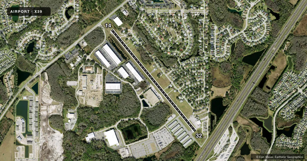
Airport sketch
Runways drawn to scale from FAA survey coordinates, rendered over satellite imagery. Not for navigation.
Approaches & charts
Services on the field
Fuel grades, oxygen, maintenance, ramp storage and lighting — as declared to the FAA by the airport operator.
Fuel & services
- Fuel
- 100LLJ8+10
- Oxygen (bottled)
- Not available
- Oxygen (bulk)
- Not available
- Airframe repair
- Major
- Power plant repair
- Major
- Other services
- INSTR,RNTL,SALES
Ramp & ground
- Transient storage
- Tie-down
- Hangar
- Landing fee
- No fee published
- Customs
- Not available
- Lighting schedule
- SEE RMK
- Beacon schedule
- SEE RMK
- Beacon
- White / Green (civil land)(WG)
- Wind indicator
- Lighted
- Segmented circle
- No
Fuel & FBOs
Cheapest 100LL and Jet A on the field and nearby. Always confirm with the FBO before taxi.
Airport notes
Surface conditions, obstructions, local procedures, lighting outages and other notes published with each FAA cycle.
General notes
- ACFT, TREES & BLDG IN TRANSITIONAL SURFACE, BOTH SIDES OF RY 14/32.
- ACFT PARKED 125 FT OF RWY CNTRLN BOTH SIDES FIRST THIRD OF RWY 32.
- FOR CD CTC TAMPA APCH AT 813-878-2528.
- RWY 14/32 HAS NSTD RSA FULL LEN ON BOTH SIDES.
Lighting notes
- DUSK-2200. AFTER 2200 ACTVT ROTG BCN - CTAF.
- MIRL RWY 14/32 PRESET LOW INTST DUSK-2200; TO INCR INTST OR ACTVT AFTER 2200 - CTAF.
Approach & departure obstructions
- 14RWY 14/32 MARKINGS FADED.
- 14RWY 14 APCH RATIO 20:1 TO DTHR.
- 32RWY 32 APPROACH SLOPE 24:1 DUE TO 44 FT POLE 925 FT FM RWY END 60 FT RIGHT OF CNTRLN.
Other notes
- VFR OPNS ONLY ON RY 14/32.
- OWNERCONTACT PERSON: CHARLES BRAMMER
- MANAGERFBO 813-973-3703.
- 14/32RWY 14/32 HAS EXCESSIVE LONGL AND TRANSVERSE CRACKING AND IS PRODUCING LOOSE AGGREGATE.
- 14/32RWY 14/32 HAS A 50 FT ASPHALT CNTR WITH A 5 FT TURF EDGE ON EACH SIDE.
VFR map & nearby airports
VFR sectional. Tap any ICAO chip to open that airport.
Key facts · X39
Answer card- ICAO
- X39
- Name
- TAMPA NORTH AERO PARK
- Location
- TAMPA, FLORIDA
- Elevation
- 68 ft MSL
- Traffic pattern altitude
- 1,068 ft MSL (1,000 AGL)
- Control tower
- Non-towered (use CTAF)
- Total runways
- 1
- Longest runway
- 14/32 · 3,541 ft
- Published ILS approaches
- 0
- Published frequencies
- 2
- Magnetic variation
- 2°
- Current flight rules
- MVFR
- Current wind
- 010° at 8 kt
- Favored runway now
- RWY 32
Tampa North Aero Park sits in Tampa, Florida at 68 ft MSL. It has one runway, 14/32, which is 3,541 ft long. The field is not towered. CTAF and UNICOM are both 123.05. No ILS approaches are published here.
Pattern altitude is not published, so plan on the standard 1,000 ft AGL unless the current Chart Supplement says otherwise. Tampa North Flight Center is on the field. It carries 100LL. The published remarks matter here. Aircraft are parked 125 feet from the runway centerline on both sides of the first third of runway 32. Runway 14/32 markings are faded. The runway lights are preset to low intensity from dusk to 2200. After 2200, use the CTAF to increase intensity or activate the beacon.
This is a VFR-only runway environment. The runway safety area is nonstandard full length on both sides. Aircraft, trees and buildings sit in the transitional surface on both sides of the runway. Runway 32 also has a steepened approach slope because of a 44-foot pole near the departure end. For clearance delivery, contact Tampa Approach. A first-time pilot should brief the runway condition, the lighting setup and the close-in obstacles before arrival.