METAR & TAF KVDF
Current METAR
Observed 11:35Z
KVDF 271135Z AUTO 00000KT 10SM FEW065 BKN100 28/26 A2992 RMK AO2 LTG DSNT N AND SE T02790263 $
- Wind
- 000° @ 0 kt
- Visibility
- 10 SM
- Temp / Dew
- 28°C / 26°C
- Altimeter
- 29.92 inHg
- Clouds
- BKN
- Density alt
- 1,586 ft
- Ceiling
- 10,000 ft AGL
- Rules
- VFR
Airport info & contacts
Manager on record, flight service, ARTCC, attendance schedule and pattern altitude — published by the FAA and refreshed every 28 days.
Location
- From city
- 6 NM E
- VFR sectional
- JACKSONVILLE
- ARTCC
- ZMA · MIAMI
- NOTAM facility
- VDF (NOTAM-D)
Airport manager
- Name
- BRETT W FAY, C.M.
- Phone
- 813-870-8735
- Address
- PO BOX 22287, TAMPA FL 33622
Flight service · Hours
- FSS PIE
- SAINT PETERSBURG1-800-WX-BRIEF
- Attendance
- MON-FRI · 0700-2200
- SAT-SUN · 0700-1900
Frequencies
Tap any row to copy the frequency to your clipboard.
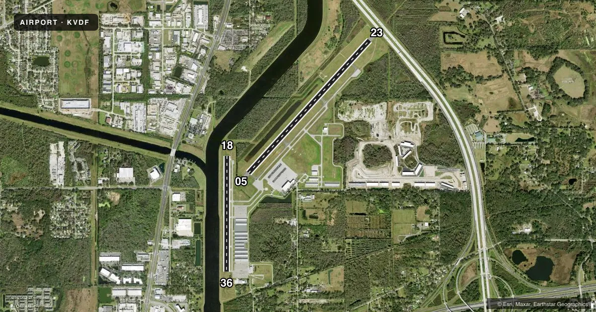
Runways & pattern
Full pagePattern entry · RWY 05
LEFT TRAFFIC| Runway | Heading (°M) | Length | Surface | Traffic |
|---|---|---|---|---|
| 05/23 | 38° / 218° | 5,000 ft | ASPH | Standard L |
| 18/36 | 176° / 356° | 3,219 ft | ASPH | Standard L |
Runway end performance
| End | TORA | TODA | ASDA | LDA | VGSI | Approach lights | Obstruction |
|---|---|---|---|---|---|---|---|
| 05 | 4,574' | 4,574' | 4,956' | 4,956' | PAPI 2-box left(3.02°) | — | 43', trees, 1955' from thr, 245' R of cntrln, slope 40 |
| 23 | 5,000' | 5,000' | 5,000' | 4,200' | PAPI 2-box left(3.1°) | MALSR | 17', road, 310' from thr, 500' R of cntrln, slope 6 |
| 18 | 3,219' | 3,219' | 3,219' | 3,219' | PAPI 4-box right(3.8°) | — | 23', brush, 480' from thr, 105' R of cntrln, slope 12 |
| 36 | 3,219' | 3,219' | 3,219' | 3,219' | PAPI 2-box left(3.4°) | — | 123', pole, 2895' from thr, 20' R of cntrln, slope 22 |
Declared distances in feet. TORA = takeoff run available, TODA = takeoff distance, ASDA = accelerate-stop, LDA = landing distance.
Airport sketch
Runways drawn to scale from FAA survey coordinates, rendered over satellite imagery. Not for navigation.
Approaches & charts
ILS · 1
Services on the field
Fuel grades, oxygen, maintenance, ramp storage and lighting — as declared to the FAA by the airport operator.
Fuel & services
- Fuel
- 100LLA
- Oxygen (bottled)
- Not available
- Oxygen (bulk)
- Not available
- Airframe repair
- Major
- Power plant repair
- Major
- Other services
- AVNCS,CHTR,INSTR,RNTL,SALES
Ramp & ground
- Transient storage
- Tie-down
- Hangar
- Landing fee
- No fee published
- Customs
- Not available
- Lighting schedule
- SEE RMK
- Beacon schedule
- SS-SR
- Beacon
- White / Green (civil land)(WG)
- Wind indicator
- Lighted
Fuel & FBOs
Cheapest 100LL and Jet A on the field and nearby. Always confirm with the FBO before taxi.
Airport notes
Surface conditions, obstructions, local procedures, lighting outages and other notes published with each FAA cycle.
General notes
- AFTER HRS FUEL AND SVCS AVBL. JET SINGLE POINT FUELING AND LAV SVS AVBL. CTC FBO ON CALL ATTENDANT AT 813-695-6097.
- CTC GENERAL AVIATION DEPT AT 813-870-8770.
- NOISE ABATEMENT PROCEDURES IN EFFECT FOR RY 18. NO TURNS UNTIL OVER INTERSTATE. NO TURNS BLO 400 FT AGL.
- WHEN DEPG RWY 05 BE ALERT FOR MALSR LGT FIXTURE LCTD 55 FT BYD RWY END & 9 FT ABV RWY END ELEV.
- FOR CD CTC TAMPA APCH ON 119.9.
- TREES 510 FT NW OF RWY 5/23 FULL LEN LCTD INSIDE TRSN SFC.
- BE ADZD OF SEAPLANE FLT ACTIVITY 3NM SE OF ARPT.
- 24 HR ADVN NOTICE OR IMT REPORTING UPON LDG FOR ACFT EQUIPPED WITH WEATHER MODIFICATION OR GEOENGINEERING EQUIP. 813-870-8770 EXT. 3
Lighting notes
- ACTVT MALSR RWY 23; REIL RWY 05, 18, 36; PAPI RWY 05, 23, 18, 36; MIRL RWY 05/23, 18/36 - CTAF.
Approach & departure obstructions
- 18RWY 18 APRCH SLOPE 20:1 TO AER.
- 23RWY 23 APCH SLOPE 50:1 TO DTHR.
Other notes
- VFR OPNS ONLY
- MANAGERAIRPORT PHYSICAL ADDRESS: 6530 TAMPA EXECUTIVE AIRPORT RD, TAMPA, FL 33610
VFR map & nearby airports
VFR sectional. Tap any ICAO chip to open that airport.
Key facts · KVDF
Answer card- ICAO
- KVDF
- Name
- TAMPA EXEC
- Location
- TAMPA, FLORIDA
- Elevation
- 21.1 ft MSL
- Traffic pattern altitude
- 1,021.1 ft MSL (1,000 AGL)
- Control tower
- Non-towered (use CTAF)
- Total runways
- 2
- Longest runway
- 05/23 · 5,000 ft
- Published ILS approaches
- 1
- Published frequencies
- 4
- Magnetic variation
- 4°
- Current flight rules
- VFR
- Current wind
- 000° at 0 kt
- Favored runway now
- –
Tampa Executive Airport sits in Tampa, Florida. The field elevation is 21.1 ft MSL. It has two asphalt runways. The longest is runway 05/23 at 5,000 ft. This is a non-towered field, so use CTAF 122.7 for local traffic calls. Tampa Approach handles clearance delivery on 119.9. The airport is published for VFR operations only.
There is one ILS approach. It serves runway 23. Pattern altitude is not published, so use standard 1,000 ft AGL for light piston operations unless the current FAA Chart Supplement says otherwise. Skyport Aviation is on the field. It carries 100LL, Jet A and Jet A Prist. After-hours fuel and services are available through the on-call attendant. The published remarks also note jet single-point fueling and lavatory service.
A first-time pilot should pay attention to the nearby traffic picture. MacDill Air Force Base military Class D airspace sits close by. There is also military pattern traffic near runway 5/23. Runway 18 has a steep approach slope note. Runway 23 has a displaced-threshold approach slope note. Trees are reported northwest of runway 5/23 inside the transition surface. Seaplane activity is reported 3 NM southeast of the airport. Use the current FAA Chart Supplement for any noise or operating restrictions before you go.