METAR & TAF KLAL
Current METAR
Observed 16:50Z
KLAL 261650Z 27009KT 10SM -RA SCT035 BKN047 28/25 A3003 RMK TS DSPTD TSE40
- Wind
- 270° @ 9 kt
- Visibility
- 10 SM
- Temp / Dew
- 28°C / 25°C
- Altimeter
- 30.03 inHg
- Clouds
- BKN
- Density alt
- 1,599 ft
- Ceiling
- 4,700 ft AGL
- Rules
- VFR
Airport info & contacts
Manager on record, flight service, ARTCC, attendance schedule and pattern altitude — published by the FAA and refreshed every 28 days.
Location
- From city
- 4 NM SW
- VFR sectional
- MIAMI
- ARTCC
- ZMA · MIAMI
- NOTAM facility
- LAL (NOTAM-D)
Airport manager
- Name
- KRIS HALLSTRAND
- Phone
- 863-834-3298
- Address
- 3900 DON EMERSON DRIVE SUITE 210, LAKELAND FL 33811-1340
Flight service · Hours
- FSS PIE
- SAINT PETERSBURG1-800-WX-BRIEF
- Attendance
- ALL
Frequencies
Tap any row to copy the frequency to your clipboard.
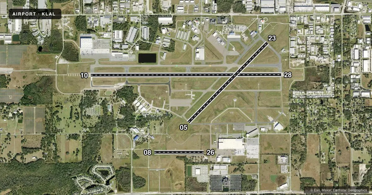
Runways & pattern
Full pagePattern entry · RWY 28
LEFT TRAFFIC| Runway | Heading (°M) | Length | Surface | Traffic |
|---|---|---|---|---|
| 10/28Favored | 84° / 264° | 8,500 ft | ASPH | Standard L |
| 05/23 | 39° / 219° | 5,000 ft | ASPH | Standard L |
| 08/26 | 84° / 264° | 2,208 ft | TURF | Standard L |
Runway end performance
| End | TORA | TODA | ASDA | LDA | VGSI | Approach lights | Obstruction |
|---|---|---|---|---|---|---|---|
| 10 | 8,500' | 8,500' | 8,500' | 8,500' | PAPI 4-box right(3°) | ALSF2 | — |
| 28 | 8,500' | 8,500' | 8,500' | 8,500' | PAPI 4-box left(3°) | — | 30', trees, 1110' from thr, 455' R of cntrln, slope 30 |
| 05 | 5,000' | 5,000' | 5,000' | 5,000' | PAPI 4-box left(3°) | — | — |
| 23 | 5,000' | 5,000' | 5,000' | 5,000' | PAPI 4-box left(3°) | — | 34', trees, 1380' from thr, 125' R of cntrln, slope 34 |
| 08 | 1,650' | 2,010' | 2,205' | 1,845' | — | — | 51', trees, 820' from thr, 200' R of cntrln, slope 16 |
| 26 | 1,845' | 2,205' | 2,205' | 1,650' | — | — | 55', hangar, 650' from thr, 145' R of cntrln, slope 11 |
Declared distances in feet. TORA = takeoff run available, TODA = takeoff distance, ASDA = accelerate-stop, LDA = landing distance.
Airport sketch
Runways drawn to scale from FAA survey coordinates, rendered over satellite imagery. Not for navigation.
Approaches & charts
ILS · 1
Services on the field
Fuel grades, oxygen, maintenance, ramp storage and lighting — as declared to the FAA by the airport operator.
Fuel & services
- Fuel
- 100LLA
- Oxygen (bottled)
- Not available
- Oxygen (bulk)
- HIGH/LOW
- Airframe repair
- Major
- Power plant repair
- Major
- Other services
- AMB,AVNCS,CARGO,CHTR,INSTR,RNTL,SALES
Ramp & ground
- Transient storage
- Hangar
- Landing fee
- No fee published
- Customs
- Not available
- Lighting schedule
- SEE RMK
- Beacon schedule
- SS-SR
- Beacon
- White / Green (civil land)(WG)
- Wind indicator
- Yes
- Segmented circle
- Yes
Fuel & FBOs
Cheapest 100LL and Jet A on the field and nearby. Always confirm with the FBO before taxi.
Airport notes
Surface conditions, obstructions, local procedures, lighting outages and other notes published with each FAA cycle.
General notes
- BIRD ACT ON & INVOF ARPT.
- TWY D, D1, & E1 UNLGTD.
- PJE WITHIN 5 NM 18000 BLW SR-SS
- INDEX C AVBL UPON REQ.
- USCBP USER FEE ARPT; SVC THUR-MON, 1530-2400Z. FEE CHRGD OUTSIDE OF SVC HOURS. FEE PAYABLE ON SITE.
- 24 HR PPR OR IMT REPORTING UPON LDG FOR ACFT EQUIPPED WITH WEATHER MODIFICATION OR GEOENGINEERING EQPT CTC OPS 863-834-4911.
Lighting notes
- PAPI RWY 05 & 23, 10 & 28 OPER CONT.
Runway surface & condition
- 05/23PCR VALUE: 320/F/A/X/T
- 10/28PCR VALUE: 460/F/A/X/T
- 05/23RWY 05/23 NOT AVBL FOR PART 121/PART 380 OPS WITH SKED PAX CARRYING OPS MORE THAN 9 PAX SEATS AND NON-SKED PAX CARRYING OPS MORE THAN 30 PAX SEATS.
- 08/26RWY 08/26 NOT AVBL FOR PART 121/PART 380 OPS WITH SKED PAX CARRYING OPS MORE THAN 9 PAX SEATS AND NON-SKED PAX CARRYING OPS MORE THAN 30 PAX SEATS. RSTRD TO GROUP 1 ACFT UNDER 1500 LBS MTOW, VFR DAYTIME ONLY, NO TGL; PPR - 863-834-4911.
Approach & departure obstructions
- 08RWY 8/26 MKD WITH PAVERS.
VFR map & nearby airports
VFR sectional. Tap any ICAO chip to open that airport.
Key facts · KLAL
Answer card- ICAO
- KLAL
- Name
- LAKELAND LINDER INTL
- Location
- LAKELAND, FLORIDA
- Elevation
- 141.8 ft MSL
- Traffic pattern altitude
- 1,141.8 ft MSL (1,000 AGL)
- Control tower
- Towered · 24
- Total runways
- 3
- Longest runway
- 10/28 · 8,500 ft
- Published ILS approaches
- 1
- Published frequencies
- 9
- Magnetic variation
- 6°
- Current flight rules
- VFR
- Current wind
- 270° at 9 kt
- Favored runway now
- RWY 28
Lakeland Linder Intl is in Lakeland, Florida. The field elevation is 141.8 ft MSL. It has three runways. The longest is runway 10/28 at 8,500 ft. The airport has a control tower that operates 24 hours. One ILS approach is published for runway 10.
Pattern altitude is not published in the facts. Use the standard 1,000 ft AGL pattern unless the current Chart Supplement says otherwise. Bird activity is reported on and near the airport, so keep a sharp scan on arrival and departure. Taxiways D, D1 and E1 are unlighted. Runway 08/26 is turf and has use limits. It is restricted to Group 1 aircraft under 1,500 lb max takeoff weight, VFR daytime only, with no touch-and-go landings. Prior permission is required before using it.
Aero Center is on the field. It carries 100LL, Jet A and Jet A Prist. This is also a U.S. Customs and Border Protection user fee airport. CBP service is Thursday through Monday from 1530 to 2400 Zulu. Outside those hours, a fee applies. The airport also notes that prohibited, restricted and warning areas are within 5 NM from 18,000 feet below sunrise to sunset. Check current procedures before you go.