METAR & TAF KGIF
Current METAR
Observed 12:08Z
KGIF 271208Z AUTO 33011G17KT 10SM FEW012 FEW023 SCT100 26/24 A2995 RMK AO1 WSHFT 1148 LTG DSNT NW T02610239 $
- Wind
- 330° @ 11G17 kt
- Visibility
- 10 SM
- Temp / Dew
- 26°C / 24°C
- Altimeter
- 29.95 inHg
- Clouds
- SCT
- Density alt
- 1,463 ft
- Ceiling
- Unlimited
- Rules
- VFR
Airport info & contacts
Manager on record, flight service, ARTCC, attendance schedule and pattern altitude — published by the FAA and refreshed every 28 days.
Location
- From city
- 3 NM NW
- VFR sectional
- JACKSONVILLE
- Pattern altitude
- 855 ft AGL · 1,001 ft MSL
- ARTCC
- ZMA · MIAMI
- NOTAM facility
- GIF (NOTAM-D)
Airport manager
- Name
- TROY HEIDEL
- Phone
- 863-298-4551
- Address
- 2073 HWY 92 WEST, WINTER HAVEN FL 33881
Flight service · Hours
- FSS PIE
- SAINT PETERSBURG1-800-WX-BRIEF
- Attendance
- 0700-1900
Frequencies
Tap any row to copy the frequency to your clipboard.
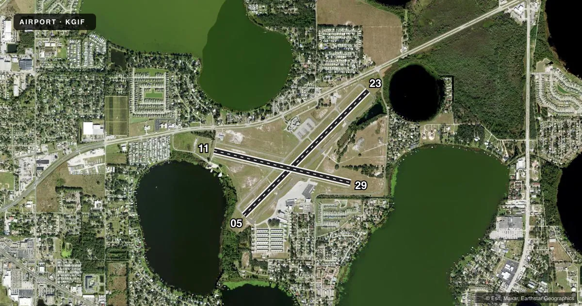
Runways & pattern
Full pagePattern entry · RWY 29
LEFT TRAFFIC| Runway | Heading (°M) | Length | Surface | Traffic |
|---|---|---|---|---|
| 05/23 | 41° / 221° | 5,005 ft | ASPH | Standard L |
| 11/29Favored | 99° / 279° | 4,001 ft | ASPH | Standard L |
Runway end performance
| End | TORA | TODA | ASDA | LDA | VGSI | Approach lights | Obstruction |
|---|---|---|---|---|---|---|---|
| 05 | — | — | — | — | PAPI 2-box left(3°) | — | 5', fence, 205' from thr, 250' R of cntrln, slope 1 |
| 23 | — | — | — | — | PAPI 2-box left(3°) | — | 41', trees, 1245' from thr, 65' R of cntrln, slope 25 |
| 11 | — | — | — | — | — | — | 43', pline, 1430' from thr, 70' R of cntrln, slope 28 |
| 29 | — | — | — | — | — | — | 5', fence, 215' from thr, 250' R of cntrln, slope 3 |
Declared distances in feet. TORA = takeoff run available, TODA = takeoff distance, ASDA = accelerate-stop, LDA = landing distance.
Airport sketch
Runways drawn to scale from FAA survey coordinates, rendered over satellite imagery. Not for navigation.
Approaches & charts
Services on the field
Fuel grades, oxygen, maintenance, ramp storage and lighting — as declared to the FAA by the airport operator.
Fuel & services
- Fuel
- 100LLAMOGAS
- Oxygen (bottled)
- Not available
- Oxygen (bulk)
- Not available
- Airframe repair
- Major
- Power plant repair
- Major
- Other services
- AVNCS,INSTR,RNTL,SALES
Ramp & ground
- Transient storage
- Tie-down
- Hangar
- Landing fee
- No fee published
- Customs
- Not available
- Lighting schedule
- SEE RMK
- Beacon schedule
- SS-SR
- Beacon
- White / Green (civil land)(WG)
- Wind indicator
- Lighted
- Segmented circle
- Yes
Fuel & FBOs
Cheapest 100LL and Jet A on the field and nearby. Always confirm with the FBO before taxi.
Airport notes
Surface conditions, obstructions, local procedures, lighting outages and other notes published with each FAA cycle.
General notes
- BROWN'S SPB LOCATED ON ADJACENT LAKE.
- ANEMOMETER REMOTED TO FBO OFFICE.
- GLIDER ACFT OPERG ON AND INVOF ARPT.
- GCO AVBL ON FREQ 121.725 THRU TAMPA CD.
- RWY 05 PREFERRED FOR CALM OR LIGHT WINDS
- FOR CD IF UNA VIA GCO CTC TAMPA APCH AT 813-878-2528.
- NMRS ACFT OPERG WO RDOS INVOF ARPT AND SPB.
- UNLGTD OBSTNS IN THE APPRCH TO RWY 05 DUE TO TREES 515 BFR AER.
Lighting notes
- ACTVT REIL RWY 11 & 29; PAPI RWY 05 & 23; MIRL RWY 05/23 & 11/29 - CTAF.
Approach & departure obstructions
- 05RWY 05 APCH SLOPE 16:1 TO AER DUE TO 33 FT TREES 515 FT FM RWY END AND 150 FT LEFT .
Other notes
- OWNERCONTACT PERSON: T. MICHAEL STAVRES
VFR map & nearby airports
VFR sectional. Tap any ICAO chip to open that airport.
Key facts · KGIF
Answer card- ICAO
- KGIF
- Name
- WINTER HAVEN RGNL
- Location
- WINTER HAVEN, FLORIDA
- Elevation
- 145.5 ft MSL
- Traffic pattern altitude
- 1,000.5 ft MSL (855 AGL)
- Control tower
- Non-towered (use CTAF)
- Total runways
- 2
- Longest runway
- 05/23 · 5,005 ft
- Published ILS approaches
- 0
- Published frequencies
- 5
- Magnetic variation
- 4°
- Current flight rules
- VFR
- Current wind
- 330° at 11 kt
- Favored runway now
- RWY 29
Winter Haven Rgnl is in Winter Haven, Florida. Field elevation is 145.5 ft MSL. The airport has two asphalt runways. The longest is runway 05/23 at 5,005 ft. There is no control tower, so expect CTAF traffic and self-announced position reports on 123.05. Pattern altitude is 855 ft AGL, which is 1,000.5 ft MSL.
No ILS approaches are published here, so plan with the current chart and the weather in mind. The on-field FBO is Winter Haven Regional Airport. It carries 100LL, Jet A, Jet A Prist and mogas. Call ahead at (863) 298-4551 if you need current ramp details or fuel availability.
A few published remarks matter here. Runway 05 has a steeper-than-normal approach path because of trees near the departure end. There are also unlighted obstructions in the runway 05 approach. Runway 05 is preferred in calm or light winds. The field also has glider activity, non-radio traffic and a nearby seaplane base on the adjacent lake. That means a careful scan is smart on every arrival and departure. The airport is in the Tampa approach area for clearances and radar services. Check the current FAA Chart Supplement for any changes before you go.