METAR & TAF X25
X25 does not publish a METAR.
Showing the nearest reporting station: KBOW (BARTOW EXEC) · 9.7 NM away. Conditions at X25 may differ.
METAR · KBOW
Observed 08:35Z
KBOW 270835Z AUTO 18004KT 10SM CLR 24/24 A2994 RMK AO2 LTG DSNT NW PWINO
- Wind
- 180° @ 4 kt
- Visibility
- 10 SM
- Temp / Dew
- 24°C / 24°C
- Altimeter
- 29.94 inHg
- Clouds
- CLR
- Density alt
- 1,216 ft
- Ceiling
- Unlimited
- Rules
- VFR
Airport info & contacts
Manager on record, flight service, ARTCC, attendance schedule and pattern altitude — published by the FAA and refreshed every 28 days.
Location
- From city
- 3 NM N
- VFR sectional
- MIAMI
- ARTCC
- ZMA · MIAMI
- NOTAM facility
- PIE (NOTAM-D)
Airport manager
- Name
- DENISE HINSHAW
- Phone
- 863-521-3348
- Address
- 3800 CHALET SUZANNE DRIVE, LAKE WALES FL 33859-7763
Flight service · Hours
- FSS PIE
- SAINT PETERSBURG1-800-WX-BRIEF
- Attendance
- Unattended
Frequencies
Tap any row to copy the frequency to your clipboard.
Runways & pattern
Full pagePattern entry · RWY 18
LEFT TRAFFICRunway end performance
| End | TORA | TODA | ASDA | LDA | VGSI | Approach lights | Obstruction |
|---|---|---|---|---|---|---|---|
| 18 | — | — | — | — | — | — | 45', tree, 1105' from thr, 0' R of cntrln, slope 25 |
| 36 | — | — | — | — | — | — | 15', road, 0' from thr, 72' R of cntrln, slope 0 |
Declared distances in feet. TORA = takeoff run available, TODA = takeoff distance, ASDA = accelerate-stop, LDA = landing distance.
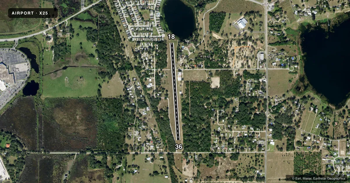
Airport sketch
Runways drawn to scale from FAA survey coordinates, rendered over satellite imagery. Not for navigation.
Approaches & charts
Services on the field
Fuel grades, oxygen, maintenance, ramp storage and lighting — as declared to the FAA by the airport operator.
Fuel & services
- Fuel
- Not available
- Oxygen (bottled)
- Not available
- Oxygen (bulk)
- Not available
- Airframe repair
- Not available
- Power plant repair
- Not available
- Other services
- AGRI
Ramp & ground
- Transient storage
- Tie-down
- Landing fee
- No fee published
- Lighting schedule
- SEE RMK
- Wind indicator
- Lighted
- Segmented circle
- No
Fuel & FBOs
Cheapest 100LL and Jet A on the field and nearby. Always confirm with the FBO before taxi.
Airport notes
Surface conditions, obstructions, local procedures, lighting outages and other notes published with each FAA cycle.
General notes
- FOR CD CTC MIAMI ARTCC AT 305-716-1731.
- UNLGTD TREES AND BLDGS 85-125 FT EAST OF CNTRLN ENTR LEN RWY 18/36.
- UNLGTD PUB ROAD 72-125 FT WEST OF CNTRLN FOR THE FIRST 250 FT RWY 36.
Lighting notes
- NSTD LGTS RY 18/36 - SS TO SR OR CALL 863-676-6011.
Approach & departure obstructions
- 18TREES 125 FT LEFT OF RWY 18 CNTRLN IN PRI SFC.
- 36ROAD 72 FT RIGHT OF RWY 36 CNTRLN IN PRI SFC.
- 18RWY 18/36 MKD WITH W TIRES & NONSTANDARD LGTS.
- 36RWY 18/36 MKD WITH W TIRES & NONSTANDARD LGTS.
- 1830 FT BLDGS 85 FT L OF CNTRLN FIRST HALF OF RY 18.
Other notes
- VFR ONLY.
- 1FOR ATTENDANT AFTER HRS CALL 863-676-6011.
- OWNERCONTACT PERSON: ERIC HINSHAW 863-676-6011
VFR map & nearby airports
VFR sectional. Tap any ICAO chip to open that airport.
Key facts · X25
Answer card- ICAO
- X25
- Name
- CHALET SUZANNE AIR STRIP
- Location
- LAKE WALES, FLORIDA
- Elevation
- 130 ft MSL
- Traffic pattern altitude
- 1,130 ft MSL (1,000 AGL)
- Control tower
- Non-towered (use CTAF)
- Total runways
- 1
- Longest runway
- 18/36 · 2,313 ft
- Published ILS approaches
- 0
- Published frequencies
- 2
- Magnetic variation
- 3°
- Current flight rules
- VFR
- Current wind
- 180° at 4 kt
- Favored runway now
- RWY 18
Chalet Suzanne Air Strip is in Lake Wales, Florida. Field elevation is 130 ft MSL. It has one runway. Runway 18/36 is 2,313 ft of turf, so plan for soft-field technique and keep performance margins honest. This is a non-towered field. CTAF and UNICOM are both 122.8. No ILS approaches are published. The pattern altitude is not published, so use the standard 1,000 ft AGL for light piston operations unless the current Chart Supplement says otherwise.
The published remarks matter here. Runway 18/36 uses nonstandard lights and white tires. The lights run from sunset to sunrise or by calling the listed number. There are trees and buildings near the runway environment. On runway 18, buildings sit close to the threshold. On runway 36, a road sits near the runway environment. The field is VFR only, so do not plan an IFR arrival. If you need clearance delivery, the published contact is Miami ARTCC. There are no on-field FBOs listed, so call the airport operator or the field contact before you go. For current operating details, verify any local procedures with the current FAA Chart Supplement or the airport operator before departure.