METAR & TAF KAVO
KAVO does not publish a METAR.
Showing the nearest reporting station: KSEF (SEBRING RGNL) · 12.8 NM away. Conditions at KAVO may differ.
METAR · KSEF
Observed 03:35Z
KSEF 270335Z AUTO 20004KT 10SM CLR 24/23 A2999 RMK AO2 T02450226
- Wind
- 200° @ 4 kt
- Visibility
- 10 SM
- Temp / Dew
- 24°C / 23°C
- Altimeter
- 29.99 inHg
- Clouds
- CLR
- Density alt
- 1,192 ft
- Ceiling
- Unlimited
- Rules
- VFR
Airport info & contacts
Manager on record, flight service, ARTCC, attendance schedule and pattern altitude — published by the FAA and refreshed every 28 days.
Location
- From city
- 2 NM W
- VFR sectional
- MIAMI
- ARTCC
- ZMA · MIAMI
- NOTAM facility
- PIE (NOTAM-D)
Airport manager
- Name
- ANDREW LIVINGSTON
- Phone
- 863-446-3244
- Address
- 1535 STATE ROAD 64 WEST, AVON PARK FL 33825
Flight service · Hours
- FSS PIE
- SAINT PETERSBURG1-800-WX-BRIEF
- Attendance
- MON-FRI · 0800-1600
Frequencies
Tap any row to copy the frequency to your clipboard.
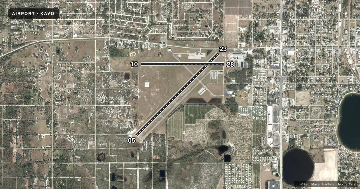
Runways & pattern
Full pagePattern entry · RWY 23
LEFT TRAFFIC| Runway | Heading (°M) | Length | Surface | Traffic |
|---|---|---|---|---|
| 05/23Favored | 40° / 220° | 5,374 ft | ASPH | Standard L |
| 10/28 | 85° / 265° | 3,844 ft | ASPH | Standard L |
Runway end performance
| End | TORA | TODA | ASDA | LDA | VGSI | Approach lights | Obstruction |
|---|---|---|---|---|---|---|---|
| 05 | — | — | — | — | PAPI 4-box left(3°) | — | 5', brush, 265' from thr, 230' R of cntrln, slope 12 |
| 23 | — | — | — | — | PAPI 4-box left(3°) | — | 15', road, 200' from thr, 250' R of cntrln, slope 0 |
| 10 | — | — | — | — | PAPI 4-box left(3°) | — | 45', trees, 1595' from thr, 60' R of cntrln, slope 31 |
| 28 | — | — | — | — | PAPI 4-box left(3°) | — | 5', fence, 221' from thr, 200' R of cntrln, slope 4 |
Declared distances in feet. TORA = takeoff run available, TODA = takeoff distance, ASDA = accelerate-stop, LDA = landing distance.
Airport sketch
Runways drawn to scale from FAA survey coordinates, rendered over satellite imagery. Not for navigation.
Approaches & charts
Services on the field
Fuel grades, oxygen, maintenance, ramp storage and lighting — as declared to the FAA by the airport operator.
Fuel & services
- Fuel
- 100LLA
- Oxygen (bottled)
- Not available
- Oxygen (bulk)
- Not available
- Airframe repair
- Major
- Power plant repair
- Major
- Other services
- AGRI,INSTR
Ramp & ground
- Transient storage
- Tie-down
- Landing fee
- No fee published
- Customs
- Not available
- Lighting schedule
- SEE RMK
- Beacon schedule
- SS-SR
- Beacon
- White / Green (civil land)(WG)
- Wind indicator
- Lighted
Fuel & FBOs
Cheapest 100LL and Jet A on the field and nearby. Always confirm with the FBO before taxi.
Airport notes
Surface conditions, obstructions, local procedures, lighting outages and other notes published with each FAA cycle.
General notes
- FOR CD IF UNA TO CTC ON FSS FREQ, CTC MIAMI ARTCC AT 305-716-1731.
- UNLGTD OBSTNS PRSNT IN THE APCH TO RY 23 DUE TO FENCE & ROAD 200 FT OF AER 23.
Lighting notes
- BEACON OTS INDEF
- MIRL RWY 05/23 & 10/28 PRESET LOW INTST DUSK-DAWN; TO INCR INTST AND ACTVT TWY LGTS, REIL RWY 05 & 23, AND PAPI RWY 05, 10, 23 & 28, - CTAF.
Approach & departure obstructions
- 23RY 23, UNLGTD 15 FT ROAD; 90 FT FM END OF RWY, 250 FT RIGHT OF CNTRLN.
- 10RWY 10/28 MARKINGS FADED.
- 28RWY 10/28 MARKINGS FADED.
- 23RWY 23 APCH RATIO 28:1 TO DTHR.
Other notes
- VFR OPNS ONLY.
- 1ON CALL SAT & SUN. CTC (863) 453-3565 FOR SVC AFTER HRS. CLSD HOLIDAYS.
- MANAGERAIRPORT PHYSICAL ADDRESS: 1545 STATE RD 64 WEST, AVON PARK, FL 33825 FAX: 863-452-4413
- OWNERGARRETT ANDERSON 863-452-4400
VFR map & nearby airports
VFR sectional. Tap any ICAO chip to open that airport.
Key facts · KAVO
Answer card- ICAO
- KAVO
- Name
- AVON PARK EXEC
- Location
- AVON PARK, FLORIDA
- Elevation
- 160.4 ft MSL
- Traffic pattern altitude
- 1,160.4 ft MSL (1,000 AGL)
- Control tower
- Non-towered (use CTAF)
- Total runways
- 2
- Longest runway
- 05/23 · 5,374 ft
- Published ILS approaches
- 0
- Published frequencies
- 2
- Magnetic variation
- 5°
- Current flight rules
- VFR
- Current wind
- 200° at 4 kt
- Favored runway now
- RWY 23
Avon Park Executive Airport is in Avon Park, Florida. The field elevation is 160.4 ft MSL. It has two asphalt runways. The longest is runway 05/23 at 5,374 ft. Runway 10/28 is 3,844 ft. There is no control tower. CTAF and UNICOM are both 122.8. No ILS approaches are published. The airport is VFR only.
Pattern altitude is not published. Use the standard 1,000 ft AGL pattern unless the current FAA Chart Supplement says otherwise. The on-field FBO is Avon Park Executive Airport. It carries AVGAS 100LL and JET A. Call 863-453-3565 for after-hours service. The airport is on call Saturday and Sunday. It is closed on holidays.
A few remarks matter here. Runway 23 has unlighted obstructions near the approach. A fence and road sit about 200 ft from the runway end. There is also an unlighted 15-foot road 90 ft from the end and 250 ft right of centerline. Runway 10/28 markings are faded. The beacon is out of service indefinitely. The runway lights are preset to low intensity from dusk to dawn. Use CTAF to increase lighting intensity and to activate taxiway lights, runway end identifier lights and the PAPI systems. For clearance delivery, if Flight Service is not available, contact Miami ARTCC. First-time pilots should plan for a non-towered VFR field with runway lighting and marking issues to brief before arrival.