METAR & TAF KCHN
KCHN does not publish a METAR.
Showing the nearest reporting station: KBOW (BARTOW EXEC) · 26.2 NM away. Conditions at KCHN may differ.
METAR · KBOW
Observed 17:15Z
KBOW 271715Z AUTO 28009KT 10SM CLR 30/24 A2995 RMK AO2 LTG DSNT SW-NW PWINO
- Wind
- 280° @ 9 kt
- Visibility
- 10 SM
- Temp / Dew
- 30°C / 24°C
- Altimeter
- 29.95 inHg
- Clouds
- CLR
- Density alt
- 1,896 ft
- Ceiling
- Unlimited
- Rules
- VFR
Airport info & contacts
Manager on record, flight service, ARTCC, attendance schedule and pattern altitude — published by the FAA and refreshed every 28 days.
Location
- From city
- 5 NM SW
- VFR sectional
- MIAMI
- ARTCC
- ZMA · MIAMI
- NOTAM facility
- PIE (NOTAM-D)
Airport manager
- Name
- WARD GRIMES
- Phone
- 863-773-3115
- Address
- 1202 MAURICE SONNY CLAVEL RD., WAUCHULA FL 33873
Flight service · Hours
- FSS PIE
- SAINT PETERSBURG1-800-WX-BRIEF
- Attendance
- UNATTND
Frequencies
Tap any row to copy the frequency to your clipboard.
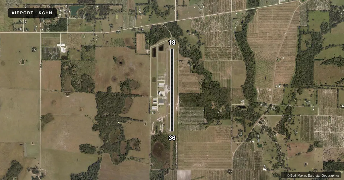
Runways & pattern
Full pagePattern entry · RWY 36
LEFT TRAFFICRunway end performance
| End | TORA | TODA | ASDA | LDA | VGSI | Approach lights | Obstruction |
|---|---|---|---|---|---|---|---|
| 18 | — | — | — | — | PAPI 4-box left(4°) | — | 24', trees, 600' from thr, 125' R of cntrln, slope 16 |
| 36 | — | — | — | — | PAPI 4-box left(3°) | — | 5', brush, 205' from thr, 225' R of cntrln, slope 1 |
Declared distances in feet. TORA = takeoff run available, TODA = takeoff distance, ASDA = accelerate-stop, LDA = landing distance.
Airport sketch
Runways drawn to scale from FAA survey coordinates, rendered over satellite imagery. Not for navigation.
Approaches & charts
Services on the field
Fuel grades, oxygen, maintenance, ramp storage and lighting — as declared to the FAA by the airport operator.
Fuel & services
- Fuel
- 100LL
- Oxygen (bottled)
- Not available
- Oxygen (bulk)
- Not available
- Airframe repair
- Minor
- Power plant repair
- Minor
- Other services
- AGRI,PAJA
Ramp & ground
- Transient storage
- Tie-down
- Landing fee
- No fee published
- Lighting schedule
- SEE RMK
- Beacon schedule
- SS-SR
- Beacon
- White / Green (civil land)(WG)
- Wind indicator
- Lighted
Fuel & FBOs
Cheapest 100LL and Jet A on the field and nearby. Always confirm with the FBO before taxi.
Airport notes
Surface conditions, obstructions, local procedures, lighting outages and other notes published with each FAA cycle.
General notes
- FOR CD CTC MIAMI ARTCC AT 305-716-1731.
Lighting notes
- ACTVT REIL RWY 18 & 36; MIRL RWY 18/36 - CTAF.
Fuel notes
- 100LLFUEL 24 HR CREDIT CARD SVC AVBL.
Other notes
- MANAGERAIRPORT PHYSICAL ADDRESS: 1202 MAURICE SONNY CLAVEL ROAD.
- OWNERCTC PERSON: OLIVIA MINSHEW
VFR map & nearby airports
VFR sectional. Tap any ICAO chip to open that airport.
Key facts · KCHN
Answer card- ICAO
- KCHN
- Name
- WAUCHULA MUNI
- Location
- WAUCHULA, FLORIDA
- Elevation
- 107.8 ft MSL
- Traffic pattern altitude
- 1,107.8 ft MSL (1,000 AGL)
- Control tower
- Non-towered (use CTAF)
- Total runways
- 1
- Longest runway
- 18/36 · 4,005 ft
- Published ILS approaches
- 0
- Published frequencies
- 1
- Magnetic variation
- 4°
- Current flight rules
- VFR
- Current wind
- 280° at 9 kt
- Favored runway now
- RWY 36
Wauchula Muni (KCHN) sits in Wauchula, Florida. Field elevation is 107.8 ft MSL. The airport has one runway. Runway 18/36 is 4,005 ft of asphalt. There is no control tower. CTAF is 122.9.
No ILS approaches are published here. The pattern altitude is not published in the facts, so use the standard 1,000 ft AGL unless the current FAA Chart Supplement says otherwise. For clearance delivery, contact Miami ARTCC at 305-716-1731. Runway end identifier lights are on runways 18 and 36. Medium intensity runway lights are also on runways 18 and 36. They are controlled by CTAF.
Wauchula Municipal Airport is the on-field FBO. It carries AVGAS 100LL. Fuel is available 24 hours with credit card service. If you need local contact details, the published contact person is Olivia Minshew. The airport physical address is 1202 Maurice Sonny Clavel Road.
For a first-time arrival, the main things to plan for are the non-towered pattern, the single runway layout and the lack of published ILS. Check the current FAA Chart Supplement for any updated procedures or restrictions before you go.