METAR & TAF X06
X06 does not publish a METAR.
Showing the nearest reporting station: KPGD (PUNTA GORDA) · 18.5 NM away. Conditions at X06 may differ.
METAR · KPGD
Observed 16:53Z
KPGD 271653Z 27011KT 10SM SCT038 33/23 A2996 RMK AO2 SLP143 T03330228
- Wind
- 270° @ 11 kt
- Visibility
- 10 SM
- Temp / Dew
- 33°C / 23°C
- Altimeter
- 29.96 inHg
- Clouds
- SCT
- Density alt
- 2,189 ft
- Ceiling
- Unlimited
- Rules
- VFR
Airport info & contacts
Manager on record, flight service, ARTCC, attendance schedule and pattern altitude — published by the FAA and refreshed every 28 days.
Location
- From city
- 1 NM SE
- VFR sectional
- MIAMI
- ARTCC
- ZMA · MIAMI
- NOTAM facility
- PIE (NOTAM-D)
Airport manager
- Name
- SHELLEY PEACOCK
- Phone
- 863-494-7844
- Address
- 2269 SE AC POLK JR DR, ARCADIA FL 34266
Flight service · Hours
- FSS PIE
- SAINT PETERSBURG1-800-WX-BRIEF
- Attendance
- 0800-1700
Frequencies
Tap any row to copy the frequency to your clipboard.
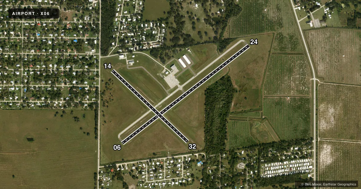
Runways & pattern
Full pagePattern entry · RWY 24
LEFT TRAFFIC| Runway | Heading (°M) | Length | Surface | Traffic |
|---|---|---|---|---|
| 06/24Favored | 46° / 226° | 3,700 ft | ASPH | Standard L |
| 14/32 | 127° / 307° | 2,400 ft | TURF | Standard L |
Runway end performance
| End | TORA | TODA | ASDA | LDA | VGSI | Approach lights | Obstruction |
|---|---|---|---|---|---|---|---|
| 06 | — | — | — | — | PAPI 2-box left(3°) | — | 15', road, 585' from thr, 125' R of cntrln, slope 25 |
| 24 | — | — | — | — | PAPI 2-box left(3°) | — | 59', trees, 1455' from thr, 135' R of cntrln, slope 21 |
| 14 | — | — | — | — | — | — | 38', tree, 385' from thr, 125' R of cntrln, slope 10 |
| 32 | — | — | — | — | — | — | 54', trees, 535' from thr, 0' R of cntrln, slope 10 |
Declared distances in feet. TORA = takeoff run available, TODA = takeoff distance, ASDA = accelerate-stop, LDA = landing distance.
Airport sketch
Runways drawn to scale from FAA survey coordinates, rendered over satellite imagery. Not for navigation.
Approaches & charts
Services on the field
Fuel grades, oxygen, maintenance, ramp storage and lighting — as declared to the FAA by the airport operator.
Fuel & services
- Fuel
- 100LL
- Oxygen (bottled)
- Not available
- Oxygen (bulk)
- Not available
- Airframe repair
- Major
- Power plant repair
- Major
- Other services
- INSTR
Ramp & ground
- Transient storage
- Tie-down
- Landing fee
- No fee published
- Customs
- Not available
- Lighting schedule
- SEE RMK
- Beacon schedule
- SS-SR
- Beacon
- White / Green (civil land)(WG)
- Wind indicator
- Lighted
- Segmented circle
- No
Fuel & FBOs
Cheapest 100LL and Jet A on the field and nearby. Always confirm with the FBO before taxi.
Airport notes
Surface conditions, obstructions, local procedures, lighting outages and other notes published with each FAA cycle.
General notes
- FOR CD CTC MIAMI ARTCC AT 305-716-1731.
Lighting notes
- ACTVT PAPI RWY 06 & 24; MIRL RWY 06/24 - CTAF.
Approach & departure obstructions
- 32MKD WITH 3 WHITE CONES.
- 14THR OUTLINED BY WHITE CONES.
- 32THR OUTLINED BY WHITE CONES.
- 14RWY 14 APCH RATIO 25:1 TO DTHR.
- 32RWY 32 APCH RATIO 23:1 TO DTHR.
Other notes
- EXISTED PRIOR TO 1959.
- MANAGERALT PH #: 863-993-5670
VFR map & nearby airports
VFR sectional. Tap any ICAO chip to open that airport.
Key facts · X06
Answer card- ICAO
- X06
- Name
- ARCADIA MUNI
- Location
- ARCADIA, FLORIDA
- Elevation
- 63 ft MSL
- Traffic pattern altitude
- 1,063 ft MSL (1,000 AGL)
- Control tower
- Non-towered (use CTAF)
- Total runways
- 2
- Longest runway
- 06/24 · 3,700 ft
- Published ILS approaches
- 0
- Published frequencies
- 2
- Magnetic variation
- 6°
- Current flight rules
- VFR
- Current wind
- 270° at 11 kt
- Favored runway now
- RWY 24
Arcadia Muni sits in Arcadia, Florida. The field elevation is 63 ft MSL. It has two runways. The longest is runway 06/24 at 3,700 ft. Runway 14/32 is 2,400 ft turf. There is no control tower. CTAF and UNICOM are both 123.0.
No ILS approaches are published here. Pattern altitude is not published, so a light piston pilot should plan on the standard 1,000 ft AGL unless the current Chart Supplement says otherwise. The on-field FBO is Arcadia Municipal Airport. It carries AVGAS 100LL. Call ahead at (863) 494-7844 if you need current ramp or fuel details.
The published remarks matter here. Runway 06 and 24 have PAPI. Medium intensity runway lights on 06 and 24 are controlled by CTAF. Runway 32 has white cone markings at the threshold. Runway 14 also has a displaced threshold marked by white cones. The remarks also note obstacle clearance slopes on the 14 and 32 approaches, so brief your descent early and confirm runway alignment before you turn final. For clearance delivery, Miami ARTCC is listed in the Chart Supplement. Check the current Chart Supplement for any noise or curfew restrictions before flying into the field.