METAR & TAF X14
X14 does not publish a METAR.
Showing the nearest reporting station: KRSW (SOUTHWEST FLORIDA INTL) · 21.4 NM away. Conditions at X14 may differ.
METAR · KRSW
Observed 11:53Z
KRSW 271153Z 00000KT 10SM CLR 28/25 A2994 RMK AO2 SLP135 70002 T02780250 10278 20261 55000
- Wind
- 000° @ 0 kt
- Visibility
- 10 SM
- Temp / Dew
- 28°C / 25°C
- Altimeter
- 29.94 inHg
- Clouds
- CLR
- Density alt
- 1,560 ft
- Ceiling
- Unlimited
- Rules
- VFR
Airport info & contacts
Manager on record, flight service, ARTCC, attendance schedule and pattern altitude — published by the FAA and refreshed every 28 days.
Location
- From city
- 1 NM S
- VFR sectional
- MIAMI
- ARTCC
- ZMA · MIAMI
- NOTAM facility
- MIA (NOTAM-D)
Airport manager
- Name
- NAOMI GILDE
- Phone
- 863-675-1568
- Address
- 311 E COWBOY WAY, LABELLE FL 33935-1607
Flight service · Hours
- FSS MIA
- MIAMI1-800-WX-BRIEF
- Attendance
- MON-FRI · 0800-1700
Frequencies
Tap any row to copy the frequency to your clipboard.
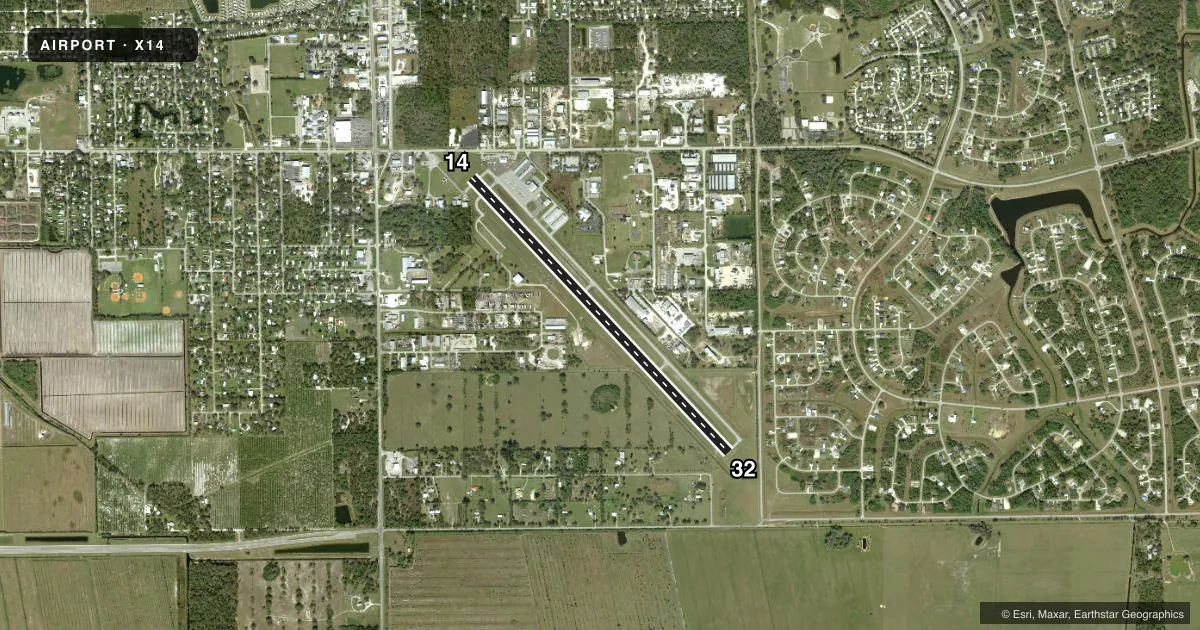
Runways & pattern
Full pagePattern entry · RWY 14
LEFT TRAFFICRunway end performance
| End | TORA | TODA | ASDA | LDA | VGSI | Approach lights | Obstruction |
|---|---|---|---|---|---|---|---|
| 14 | 5,254' | 5,254' | 5,254' | 4,903' | PAPI 4-box left(3°) | — | 15', road, 257' from thr, 250' R of cntrln, slope 3 |
| 32 | 5,254' | 5,254' | 5,254' | 5,125' | PAPI 4-box left(3°) | — | 15', road, 365' from thr, 250' R of cntrln, slope 11 |
Declared distances in feet. TORA = takeoff run available, TODA = takeoff distance, ASDA = accelerate-stop, LDA = landing distance.
Airport sketch
Runways drawn to scale from FAA survey coordinates, rendered over satellite imagery. Not for navigation.
Approaches & charts
Services on the field
Fuel grades, oxygen, maintenance, ramp storage and lighting — as declared to the FAA by the airport operator.
Fuel & services
- Fuel
- 100LLA
- Oxygen (bottled)
- Not available
- Oxygen (bulk)
- Not available
- Airframe repair
- Minor
- Power plant repair
- Major
- Other services
- AGRI,AVNCS,GLD,INSTR,TOW
Ramp & ground
- Transient storage
- Tie-down
- Landing fee
- No fee published
- Customs
- Not available
- Lighting schedule
- SEE RMK
- Beacon schedule
- SS-SR
- Beacon
- White / Green (civil land)(WG)
- Wind indicator
- Lighted
- Segmented circle
- No
Fuel & FBOs
Cheapest 100LL and Jet A on the field and nearby. Always confirm with the FBO before taxi.
Airport notes
Surface conditions, obstructions, local procedures, lighting outages and other notes published with each FAA cycle.
General notes
- TKOFS AND LNDGS ON TURF AREAS NA.
- GLDR ACTVTY WITHIN 5 NM SFC-6000 FT.
- FOR CD CTC FORT MYERS APCH AT 239-416-1026, WHEN APCH CLSD CTC MIAMI ARTCC AT 305-716-1731.
- 7 FT FENCE 300 FT FM AER RWY 14 165 FT LEFT.
Lighting notes
- ACTVT REIL RWY 14 & 32; PAPI RWY 14 & 32; MIRL RWY 14/32 - CTAF.
Fuel notes
- 100LLFUEL AVBL H24 WIH CREDIT CARD.
Approach & departure obstructions
- 14RWY 14 APCH RATIO 24:1 TO DTHR DUE TO 36 FT TREES 170 FT L OF CNTRLN 505 FT FM DTHR.
- 32RWY 32 APCH RATIO 34:1 TO DTHR.
Other notes
- OWNERCTC PERSON: TOMMY VAUGHAN 863-675-5252.
VFR map & nearby airports
VFR sectional. Tap any ICAO chip to open that airport.
Key facts · X14
Answer card- ICAO
- X14
- Name
- LA BELLE MUNI
- Location
- LA BELLE, FLORIDA
- Elevation
- 20.2 ft MSL
- Traffic pattern altitude
- 1,020.2 ft MSL (1,000 AGL)
- Control tower
- Non-towered (use CTAF)
- Total runways
- 1
- Longest runway
- 14/32 · 5,254 ft
- Published ILS approaches
- 0
- Published frequencies
- 3
- Magnetic variation
- 5°
- Current flight rules
- VFR
- Current wind
- 000° at 0 kt
- Favored runway now
- –
La Belle Muni sits in La Belle, Florida. Field elevation is 20.2 ft MSL. The airport has one runway. Runway 14/32 is 5,254 ft long with an asphalt surface. There is no control tower. Pattern altitude is not published. Use the standard 1,000 ft AGL pattern unless local guidance says otherwise.
No ILS approaches are published here. Runway 14 and runway 32 both have lighting aids. REILs are installed on both ends. PAPI is available on both ends. Medium intensity runway lights are on runway 14/32 and are controlled by CTAF. The published remarks also note 24-hour 100LL self-serve fuel with credit card use. The on-field FBO is La Belle Municipal Airport. It carries 100LL and Jet A. Call (863) 675-1568 for current details.
First-time visitors should pay attention to the published obstructions. Runway 14 has trees near the approach path. Runway 32 also has a published approach slope note. Glider activity is reported within 5 NM from the surface up to 6,000 ft. Turf takeoffs and landings are not authorized. For clearance delivery, contact Fort Myers Approach. If approach is closed, use Miami ARTCC. This is a low-elevation Florida field with a single paved runway, so plan for normal coastal and busy-airspace awareness rather than terrain issues.