METAR & TAF KRSW
Current METAR
Observed 12:53Z
KRSW 271253Z 25003KT 10SM CLR 29/25 A2996 RMK AO2 SLP141 T02940250
- Wind
- 250° @ 3 kt
- Visibility
- 10 SM
- Temp / Dew
- 29°C / 25°C
- Altimeter
- 29.96 inHg
- Clouds
- CLR
- Density alt
- 1,667 ft
- Ceiling
- Unlimited
- Rules
- VFR
Airport info & contacts
Manager on record, flight service, ARTCC, attendance schedule and pattern altitude — published by the FAA and refreshed every 28 days.
Location
- From city
- 10 NM SE
- VFR sectional
- MIAMI
- ARTCC
- ZMA · MIAMI
- NOTAM facility
- RSW (NOTAM-D)
Airport manager
- Name
- STEVEN HENNIGAN, C.M., A.C.E.
- Phone
- 239-590-4810
- Address
- 11000 TERMINAL ACCESS RD., FORT MYERS FL 33913
Flight service · Hours
- FSS MIA
- MIAMI1-800-WX-BRIEF
- Attendance
- 0700-0100
Frequencies
Tap any row to copy the frequency to your clipboard.
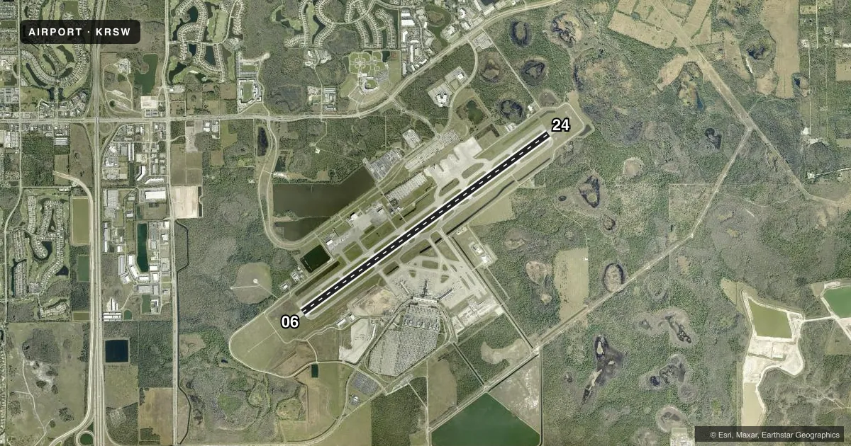
Runways & pattern
Full pagePattern entry · RWY 24
LEFT TRAFFICRunway end performance
| End | TORA | TODA | ASDA | LDA | VGSI | Approach lights | Obstruction |
|---|---|---|---|---|---|---|---|
| 06 | — | — | — | — | PAPI 4-box left(3°) | MALSR | — |
| 24 | — | — | — | — | PAPI 4-box left(3°) | — | — |
Declared distances in feet. TORA = takeoff run available, TODA = takeoff distance, ASDA = accelerate-stop, LDA = landing distance.
Airport sketch
Runways drawn to scale from FAA survey coordinates, rendered over satellite imagery. Not for navigation.
Approaches & charts
ILS · 1
Services on the field
Fuel grades, oxygen, maintenance, ramp storage and lighting — as declared to the FAA by the airport operator.
Fuel & services
- Fuel
- 100LLAA+
- Oxygen (bottled)
- HIGH/LOW
- Oxygen (bulk)
- HIGH/LOW
- Airframe repair
- Major
- Power plant repair
- Major
- Other services
- CARGO
Ramp & ground
- Transient storage
- Tie-down
- Hangar
- Landing fee
- Yes
- Customs
- Not available
- Lighting schedule
- SEE RMK
- Beacon schedule
- SS-SR
- Beacon
- White / Green (civil land)(WG)
- Wind indicator
- Lighted
- Segmented circle
- Yes
Fuel & FBOs
Cheapest 100LL and Jet A on the field and nearby. Always confirm with the FBO before taxi.
Airport notes
Surface conditions, obstructions, local procedures, lighting outages and other notes published with each FAA cycle.
General notes
- NO HELI OPS PERMITTED ON TRML APRON.
- LGTS ON PARALLEL ROAD & PARKING LOT NW OF RWY 06/24 CAN BE MISTAKEN FOR RWY & APCH ENVIRONMENT.
- GND CLNC RQRD PRIOR TO ENTERING TWY G.
- RWY USE PROGRAM IN EFFECT; USE DISTANT NOISE ABATEMENT DEP PROFILE. VISUAL APCH TO RWY 06 W OF FORT MYERS BEACH MAINTAIN 3000 FT UNTIL CROSSING SHORELINE 12 NM SW OF ARPT. RWY 24 PREFERRED BTN 2200-0600. FOR NOISE ABATEMENT PROC CTC AMGR.
- CAUTION: OPEN BAGGAGE BAYS & CONST WITHIN TERMINAL RAMP AREA. AIRCREWS USE MINIMUM THRUST SETTINGS IN THESE AREAS, SPCLY DURG SINGLE ENG TAXI. CROSS-BLEED STARTS ONLY ALLOWED AFT REACHING THE TUG RELEASE POINT.
- TFC PROCD DRCTLY TO GATE UNLESS DRCTD BY ATC; ADVISE ATC IF GATE IS NOT AVBL.
- DEP - ACFT MUST OBTAIN APVL FM GND CTL PRIOR TO PUSHBACK FM GATES B7, B9, C8, C9, D9 AND D11. PILOTS ADVISE TUG OPRS THAT YOU HAVE OBTAINED CLNC FM GND CTL PRIOR TO ENTERING TWY G.
- GATES B7 & B9 EXP CALL SPOT 7. GATES C8 & C9 EXP CALL SPOT 4. GATES D9 & D11 EXP CALL SPOT 2.
- FOR CD WHEN ATCT CLSD, CTC MIAMI ARTCC AT 305-716-1731.
- TWY A5 BTN FBO RAMP AND TWY A CLSD TO ACFT WINGSPAN MORE THAN 118 FT.
- CAUTION: GS ANT 130 FT SW OF TWY A CNTRLN BTN TWY A1 & TWY A2.
- OPERATE TRANSPONDERS WITH ALTITUDE REPORTING MODE AND ADS-B (IF EQUIPPED) ENABLED ON ALL AIRPORT SURFACES.
- ALL ACFT ON RAMP EXP CLKWS FLOW. OBND TFC FM GATES D6, D8 & D10 PCD TO CALL SPOT 1; GATES D9 AND D11 EXP CALL SPOT 2. OBND TFC FM GATES C2, C4, C6, D1, D3, D5 & D7 PCD TO CALL SPOT 3; OBND TFC FM GATES B2, B4, B6, B8, C1, C3, C5 & C7 PCD TO CALL SPOT 5; OBND TFC FM GATES B1, B3 & B5 PCD TO CALL SPOT 9; ALL OBND TFC REQ TAXI INSTRUCTIONS.
- 24 HR PPR FOR ACFT EQUIPPED WITH WEATHER MODIFICATION OR GEOENGINEERING EQPT 239-590-4810.
Lighting notes
- ACTVT MALSR RWY 06 - CTAF. ALL OTHER LGTS OPR CONSLY.
Runway surface & condition
- 06/24PCR VALUE: 740/F/A/X/T
Other notes
- FEES FOR CHARTER, TRAVEL CLUBS & REVENUE PRODUCING ACFT.
- US CUSTOMS USER FEE ARPT.
VFR map & nearby airports
VFR sectional. Tap any ICAO chip to open that airport.
Key facts · KRSW
Answer card- ICAO
- KRSW
- Name
- SOUTHWEST FLORIDA INTL
- Location
- FORT MYERS, FLORIDA
- Elevation
- 29.9 ft MSL
- Traffic pattern altitude
- 1,029.9 ft MSL (1,000 AGL)
- Control tower
- Towered · 0600-0000
- Total runways
- 1
- Longest runway
- 06/24 · 12,000 ft
- Published ILS approaches
- 1
- Published frequencies
- 25
- Magnetic variation
- 4°
- Current flight rules
- VFR
- Current wind
- 250° at 3 kt
- Favored runway now
- RWY 24
Southwest Florida Intl is in Fort Myers, Florida. The field elevation is 29.9 ft MSL. It has one runway, 06/24, which is 12,000 ft long. The tower is open from 0600 to 0000. One ILS approach is published for runway 06. Pattern altitude is not published, so use 1,000 ft AGL for light piston traffic unless the current Chart Supplement says otherwise.
PrivateSky is on the field. It carries 100LL, Jet A and Jet A Prist. Call them at (239) 225-6100 for current service details. This is a busy Class C airport with airline and business traffic. Expect a runway use program and follow the published noise abatement flow. Runway 24 is preferred between 2200 and 0600. For a visual to 06 west of Fort Myers Beach, maintain 3,000 ft until crossing the shoreline 12 NM southwest of the airport. That matters here because the field sits close to the coast. The traffic mix is heavy.
There are also ramp and taxi cautions to brief before arrival. Ground approval is required before pushback from several gates. Taxiway A5 is closed to aircraft with wingspans over 118 ft. Open baggage bays, construction and misleading lights northwest of runway 06/24 are all noted hazards. Check the current Chart Supplement and coordinate with the airport operator or the FBO directly if you need the latest ramp or noise details.