METAR & TAF KMKY
Current METAR
Observed 12:56Z
KMKY 271256Z AUTO 30004KT 10SM CLR 30/26 A2997 RMK AO2 SLP147 T03000256 PNO $
- Wind
- 300° @ 4 kt
- Visibility
- 10 SM
- Temp / Dew
- 30°C / 26°C
- Altimeter
- 29.97 inHg
- Clouds
- CLR
- Density alt
- 1,744 ft
- Ceiling
- Unlimited
- Rules
- VFR
Airport info & contacts
Manager on record, flight service, ARTCC, attendance schedule and pattern altitude — published by the FAA and refreshed every 28 days.
Location
- From city
- 4 NM NE
- VFR sectional
- MIAMI
- ARTCC
- ZMA · MIAMI
- NOTAM facility
- MIA (NOTAM-D)
Airport manager
- Name
- BRYANT GARRETT
- Phone
- 239-252-8425
- Address
- 2005 MAINSAIL DRIVE, SUITE 1, NAPLES FL 34114
Flight service · Hours
- FSS MIA
- MIAMI1-800-WX-BRIEF
- Attendance
- 0700-1900
Frequencies
Tap any row to copy the frequency to your clipboard.
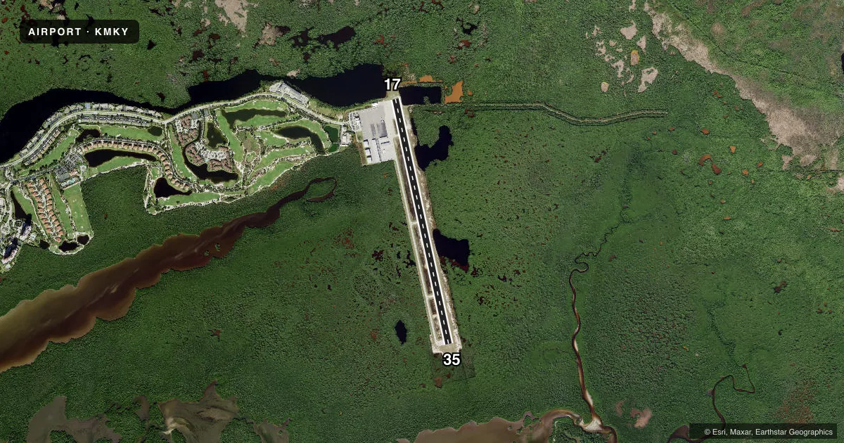
Runways & pattern
Full pagePattern entry · RWY 35
RIGHT TRAFFICRunway end performance
| End | TORA | TODA | ASDA | LDA | VGSI | Approach lights | Obstruction |
|---|---|---|---|---|---|---|---|
| 17 | — | — | — | — | PAPI 4-box left(3°) | — | 12', brush, 355' from thr, 0' R of cntrln, slope 12 |
| 35 | — | — | — | — | PAPI 4-box left(3°) | — | 5', brush, 328' from thr, 0' R of cntrln, slope 28 |
Declared distances in feet. TORA = takeoff run available, TODA = takeoff distance, ASDA = accelerate-stop, LDA = landing distance.
Airport sketch
Runways drawn to scale from FAA survey coordinates, rendered over satellite imagery. Not for navigation.
Approaches & charts
Services on the field
Fuel grades, oxygen, maintenance, ramp storage and lighting — as declared to the FAA by the airport operator.
Fuel & services
- Fuel
- 100LLAA+
- Oxygen (bottled)
- Not available
- Oxygen (bulk)
- Not available
- Airframe repair
- Minor
- Power plant repair
- Minor
- Other services
- CHTR,INSTR,RNTL
Ramp & ground
- Transient storage
- Tie-down
- Landing fee
- Yes
- Customs
- Not available
- Lighting schedule
- SEE RMK
- Beacon schedule
- SS-SR
- Beacon
- White / Green (civil land)(WG)
- Wind indicator
- Lighted
- Segmented circle
- Yes
Fuel & FBOs
Cheapest 100LL and Jet A on the field and nearby. Always confirm with the FBO before taxi.
Airport notes
Surface conditions, obstructions, local procedures, lighting outages and other notes published with each FAA cycle.
General notes
- ARPT VSBY UNRELIABLE.
- NOISE SENSITIVE AREA. USE NBAA CLOSE IN NOISE ABATEMMENT PROCEDURES.
- BANNER TOWING ON AND INVOF ARPT.
- FOR FUEL AND SVC AFTER HRS CALL 239-252-8380.
- NUMEROUS BIRDS & WILDLIFE ON AND INVOF ARPT.
- FOR CD CTC FORT MYERS APCH AT239-416-1026, WHEN APCH CLSD CTC MIAMI ARTCC AT 305-716-1731.
- RWY 35 DSGND CALM WIND RWY FOR ARRS 2200-0700. RWY 17 DSGND CALM WIND RWY FOR DEPS 2200-0700.
- FM NOV 1ST TO APR 30TH - 24 HR PPR REQ FOR ACFT OVNGT PRKG.
Lighting notes
- ACTVT REIL RWY 17 & 35; PAPI RWY 17 & 35; MIRL RWY 17/35 - CTAF.
Fuel notes
- 100LLSELF SVC AVGAS 100LL AVBL 24 HRS BY CREDIT CARD.
Approach & departure obstructions
- 17RWY 17 APCH RATIO 27:1 TO RWY END.
- 35RY 35 APCH RATIO 34:1 TO RY END.
Other notes
- RAMP FEE
VFR map & nearby airports
VFR sectional. Tap any ICAO chip to open that airport.
Key facts · KMKY
Answer card- ICAO
- KMKY
- Name
- MARCO ISLAND EXEC
- Location
- MARCO ISLAND, FLORIDA
- Elevation
- 5.2 ft MSL
- Traffic pattern altitude
- 1,005.2 ft MSL (1,000 AGL)
- Control tower
- Non-towered (use CTAF)
- Total runways
- 1
- Longest runway
- 17/35 · 5,000 ft
- Published ILS approaches
- 0
- Published frequencies
- 5
- Magnetic variation
- 3°
- Current flight rules
- VFR
- Current wind
- 300° at 4 kt
- Favored runway now
- RWY 35
Marco Island Executive Airport sits in Marco Island, Florida. Field elevation is 5.2 ft MSL. The airport has one runway. Runway 17/35 is 5,000 ft asphalt. That is the longest runway on the field. There is no control tower. The published pattern altitude is not listed, so use the standard 1,000 ft AGL for light piston operations unless the current FAA Chart Supplement says otherwise.
No ILS approaches are published here. The field uses CTAF 122.7 and UNICOM 122.7. For clearance delivery, Fort Myers Approach is listed on the published frequencies. When approach is closed, contact Miami ARTCC. The airport is noise sensitive. NBAA close-in noise abatement procedures are published, so plan your arrival and departure with that in mind. Runway 35 is the calm wind arrival runway from 2200 to 0700. Runway 17 is the calm wind departure runway from 2200 to 0700.
Marco Island Executive Airport has one on-field FBO. Marco Island Executive Airport carries 100LL, Jet A and Jet A Prist. Self-serve 100LL is available 24 hours by credit card. Published remarks also note ramp fees. Overnight parking permission is required 24 hours in advance from November 1 to April 30. Birds and wildlife are in the area. Banner towing activity is nearby. Runway 17 and 35 have REILs, PAPI and medium intensity lights controlled by CTAF. The runway 17 approach and runway 35 approach both have published obstacle clearance slopes, so a stable approach matters here.