METAR & TAF KIMM
KIMM does not publish a METAR.
Showing the nearest reporting station: KRSW (SOUTHWEST FLORIDA INTL) · 20.0 NM away. Conditions at KIMM may differ.
METAR · KRSW
Observed 16:53Z
KRSW 271653Z VRB05KT 10SM CLR 33/23 A2995 RMK AO2 SLP140 T03280233
- Wind
- VAR @ 5 kt
- Visibility
- 10 SM
- Temp / Dew
- 33°C / 23°C
- Altimeter
- 29.95 inHg
- Clouds
- CLR
- Density alt
- 2,169 ft
- Ceiling
- Unlimited
- Rules
- VFR
Airport info & contacts
Manager on record, flight service, ARTCC, attendance schedule and pattern altitude — published by the FAA and refreshed every 28 days.
Location
- From city
- 1 NM NE
- VFR sectional
- MIAMI
- ARTCC
- ZMA · MIAMI
- NOTAM facility
- MIA (NOTAM-D)
Airport manager
- Name
- BRYANT GARRETT
- Phone
- 239-252-8425
- Address
- 165 AIRPARK BLVD, IMMOKALEE FL 34142
Flight service · Hours
- FSS MIA
- MIAMI1-800-WX-BRIEF
- Attendance
- 0800-1800
Frequencies
Tap any row to copy the frequency to your clipboard.
Runways & pattern
Full pagePattern entry · RWY 36
LEFT TRAFFIC| Runway | Heading (°M) | Length | Surface | Traffic |
|---|---|---|---|---|
| 09/27 | 84° / 264° | 5,000 ft | ASPH | Standard L |
| 18/36Favored | 173° / 353° | 4,550 ft | ASPH | Standard L |
Runway end performance
| End | TORA | TODA | ASDA | LDA | VGSI | Approach lights | Obstruction |
|---|---|---|---|---|---|---|---|
| 09 | — | — | — | — | PAPI 4-box left(3°) | — | 21', trees, 920' from thr, 285' R of cntrln, slope 34 |
| 27 | — | — | — | — | PAPI 4-box left(3°) | — | 12', trees, 695' from thr, 250' R of cntrln, slope 41 |
| 18 | — | — | — | — | PAPI 4-box left(3°) | — | 19', trees, 900' from thr, 225' R of cntrln, slope 36 |
| 36 | — | — | — | — | PAPI 4-box left(3°) | — | 42', tree, 1875' from thr, 225' R of cntrln, slope 40 |
Declared distances in feet. TORA = takeoff run available, TODA = takeoff distance, ASDA = accelerate-stop, LDA = landing distance.
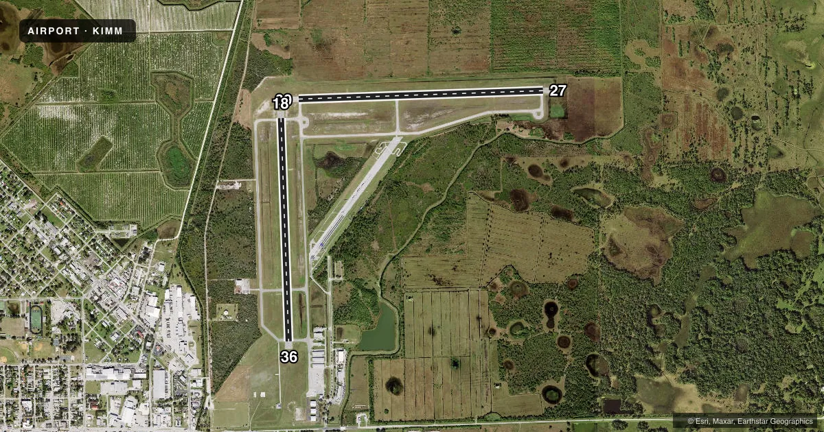
Airport sketch
Runways drawn to scale from FAA survey coordinates, rendered over satellite imagery. Not for navigation.
Approaches & charts
Services on the field
Fuel grades, oxygen, maintenance, ramp storage and lighting — as declared to the FAA by the airport operator.
Fuel & services
- Fuel
- 100LLAA+
- Oxygen (bottled)
- Not available
- Oxygen (bulk)
- Not available
- Airframe repair
- Minor
- Power plant repair
- Minor
- Other services
- AGRI,CHTR,GLD
Ramp & ground
- Transient storage
- Tie-down
- Hangar
- Landing fee
- No fee published
- Customs
- Not available
- Lighting schedule
- SEE RMK
- Beacon schedule
- SS-SR
- Beacon
- White / Green (civil land)(WG)
- Wind indicator
- Lighted
Fuel & FBOs
Cheapest 100LL and Jet A on the field and nearby. Always confirm with the FBO before taxi.
Airport notes
Surface conditions, obstructions, local procedures, lighting outages and other notes published with each FAA cycle.
General notes
- CROP DUSTING ACTVTY DURG DALGT HRS.
- WILDLIFE, BANNER TOWING & ULTRALIGHT ACTVTY ON AND INVOF ARPT.
- AFT HR SVC - AMGR.
- FOR CD CTC FORT MYERS APCH AT 239-416-1026, WHEN APCH CLSD CTC MIAMI ARTCC AT 305-716-1731.
Lighting notes
- ACTVT REIL RWY 9, 27, 18, & 36; MIRL RWY 09/27 & 18/36 - CTAF.
Fuel notes
- 100LLCREDIT CARD FUEL AVBL H24.
Other notes
- VFR ONLY
- MANAGERALT CTC: SPENCER BRILLON (239) 252-8393
VFR map & nearby airports
VFR sectional. Tap any ICAO chip to open that airport.
Key facts · KIMM
Answer card- ICAO
- KIMM
- Name
- IMMOKALEE RGNL
- Location
- IMMOKALEE, FLORIDA
- Elevation
- 37.1 ft MSL
- Traffic pattern altitude
- 1,037.1 ft MSL (1,000 AGL)
- Control tower
- Non-towered (use CTAF)
- Total runways
- 2
- Longest runway
- 09/27 · 5,000 ft
- Published ILS approaches
- 0
- Published frequencies
- 3
- Magnetic variation
- 5°
- Current flight rules
- VFR
- Current wind
- 000° at 5 kt
- Favored runway now
- RWY 36
Immokalee Regional Airport sits in Immokalee, Florida. Field elevation is 37.1 ft MSL. The airport has two asphalt runways. The longest is 09/27 at 5,000 ft. The other runway is 18/36 at 4,550 ft. There is no control tower. CTAF is 122.9.
No ILS approaches are published here. The field is VFR only, so plan accordingly. Pattern altitude is not published. Use the standard 1,000 ft AGL pattern for light piston traffic unless the current Chart Supplement says otherwise. That puts the pattern at about 1,037 ft MSL based on field elevation.
The on-field FBO is Immokalee Regional Airport. It carries 100LL, Jet A and Jet A Prist. Credit card fuel is available 24 hours a day. The airport remarks also note after-hours service through the airport manager.
First-time visitors should pay attention to the local traffic picture. Wildlife, banner towing, ultralight activity and crop dusting all occur here. That means a careful scan on arrival and departure is smart. Runway lighting is pilot-controlled on the CTAF. REILs are available on all four runway ends. For clearance delivery, Fort Myers Approach is the published contact. When approach is closed, Miami ARTCC is the backup contact.