METAR & TAF 2IS
Current METAR
Observed 21:55Z
K2IS 082155Z AUTO 06023KT 10SM BKN021 OVC028 23/19 A3000 RMK AO2 T02330190
- Wind
- 060° @ 23 kt
- Visibility
- 10 SM
- Temp / Dew
- 23°C / 19°C
- Altimeter
- 30.00 inHg
- Clouds
- OVC
- Density alt
- 886 ft
- Ceiling
- 2,100 ft AGL
- Rules
- MVFR
Airport info & contacts
Manager on record, flight service, ARTCC, attendance schedule and pattern altitude — published by the FAA and refreshed every 28 days.
Location
- From city
- 5 NM W
- VFR sectional
- MIAMI
- ARTCC
- ZMA · MIAMI
- NOTAM facility
- MIA (NOTAM-D)
Airport manager
- Name
- ERIKA ALMANZA
- Phone
- 863-656-4066
- Address
- 1090 AIRGLADES BLVD, SUITE 200, CLEWISTON FL 33440
Flight service · Hours
- FSS MIA
- MIAMI1-800-WX-BRIEF
- Attendance
- MON-FRI · 0800-1700
Frequencies
Tap any row to copy the frequency to your clipboard.
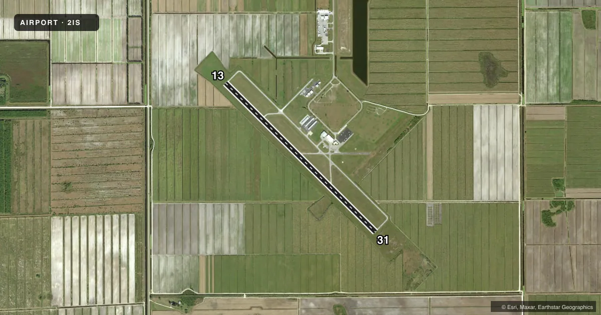
Runways & pattern
Full pagePattern entry · RWY 13
RIGHT TRAFFICRunway end performance
| End | TORA | TODA | ASDA | LDA | VGSI | Approach lights | Obstruction |
|---|---|---|---|---|---|---|---|
| 31 | — | — | — | — | — | — | 41', tree, 1855' from thr, 185' R of cntrln, slope 40 |
Declared distances in feet. TORA = takeoff run available, TODA = takeoff distance, ASDA = accelerate-stop, LDA = landing distance.
Airport sketch
Runways drawn to scale from FAA survey coordinates, rendered over satellite imagery. Not for navigation.
Approaches & charts
Services on the field
Fuel grades, oxygen, maintenance, ramp storage and lighting — as declared to the FAA by the airport operator.
Fuel & services
- Fuel
- 100LLA
- Oxygen (bottled)
- Not available
- Oxygen (bulk)
- Not available
- Airframe repair
- Minor
- Power plant repair
- Minor
- Other services
- AGRI,INSTR,PAJA,RNTL,SALES
Ramp & ground
- Transient storage
- Tie-down
- Landing fee
- No fee published
- Customs
- Not available
- Lighting schedule
- SEE RMK
- Beacon schedule
- SS-SR
- Beacon
- White / Green (civil land)(WG)
- Wind indicator
- Lighted
Fuel & FBOs
Cheapest 100LL and Jet A on the field and nearby. Always confirm with the FBO before taxi.
Airport notes
Surface conditions, obstructions, local procedures, lighting outages and other notes published with each FAA cycle.
General notes
- FOR CD CTC MIAMI ARTCC AT 305-716-1731.
Lighting notes
- ACTVT MIRL RWY 13/31 - CTAF.
Fuel notes
- 100LLSELF SVC.
- ASELF SVC.
Other notes
- VFR ONLY.
- MANAGER863-983-6151
- OWNERJENNIFER DAVIS 863-675-5220.
VFR map & nearby airports
VFR sectional. Tap any ICAO chip to open that airport.
Key facts · 2IS
Answer card- ICAO
- 2IS
- Name
- AIRGLADES
- Location
- CLEWISTON, FLORIDA
- Elevation
- 20.2 ft MSL
- Traffic pattern altitude
- 1,020.2 ft MSL (1,000 AGL)
- Control tower
- Non-towered (use CTAF)
- Total runways
- 1
- Longest runway
- 13/31 · 5,902 ft
- Published ILS approaches
- 0
- Published frequencies
- 2
- Magnetic variation
- 5°
- Current flight rules
- MVFR
- Current wind
- 060° at 23 kt
- Favored runway now
- RWY 13
Airglades Airport (2IS) is in Clewiston, Florida. Field elevation is 20.2 ft MSL. The airport has one runway. Runway 13/31 is 5,902 ft of asphalt, so it gives light aircraft plenty of room and it can handle larger single-engine and many light twin operations with normal planning. There is no control tower. CTAF and UNICOM are both 123.05.
No ILS approaches are published here. This is a VFR-only field, so check weather and ceilings carefully before you launch. Pattern altitude is not published in the facts, so use the current FAA Chart Supplement for the correct traffic pattern entry and any local notes before arrival. Medium intensity runway lights on 13/31 are pilot-activated by the common traffic advisory frequency, which is useful for after-dark arrivals.
Airglades Airport is the on-field FBO. It carries 100LL and Jet A. Both fuels are self-serve. For clearance delivery, contact Miami ARTCC at 305-716-1731. If you need current local operating details, call the airport manager or the airport operator directly before you go. The airport sits in South Florida lowlands, so expect a flat environment with little terrain relief. Still plan for heat and density altitude on warm days.