METAR & TAF X10
X10 does not publish a METAR.
Showing the nearest reporting station: KDJT (PRESIDENT DONALD J TRUMP INTL) · 30.3 NM away. Conditions at X10 may differ.
METAR · KDJT
Observed 10:53Z
KDJT 271053Z 23005KT 10SM SCT250 24/23 A2994 RMK AO2 SLP137 T02440233
- Wind
- 230° @ 5 kt
- Visibility
- 10 SM
- Temp / Dew
- 24°C / 23°C
- Altimeter
- 29.94 inHg
- Clouds
- SCT
- Density alt
- 1,068 ft
- Ceiling
- Unlimited
- Rules
- VFR
Airport info & contacts
Manager on record, flight service, ARTCC, attendance schedule and pattern altitude — published by the FAA and refreshed every 28 days.
Location
- From city
- 1 NM NE
- VFR sectional
- MIAMI
- ARTCC
- ZMA · MIAMI
- NOTAM facility
- MIA (NOTAM-D)
Airport manager
- Name
- DIANA HUGHES
- Phone
- 561-992-1610
- Address
- 110 DR MARTIN LUTHER KING JR BLVD, BELLE GLADE FL 33430
Flight service · Hours
- FSS MIA
- MIAMI1-800-WX-BRIEF
- Attendance
- Unattended
Frequencies
Tap any row to copy the frequency to your clipboard.
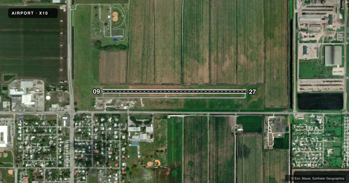
Runways & pattern
Full pagePattern entry · RWY 27
LEFT TRAFFICRunway end performance
| End | TORA | TODA | ASDA | LDA | VGSI | Approach lights | Obstruction |
|---|---|---|---|---|---|---|---|
| 09 | 3,750' | 3,750' | — | — | — | — | 44', tree, 910' from thr, 90' R of cntrln, slope 16 |
| 27 | 3,750' | 3,750' | — | — | — | — | 50', pole, 1342' from thr, 20' R of cntrln, slope 23 |
Declared distances in feet. TORA = takeoff run available, TODA = takeoff distance, ASDA = accelerate-stop, LDA = landing distance.
Airport sketch
Runways drawn to scale from FAA survey coordinates, rendered over satellite imagery. Not for navigation.
Approaches & charts
Services on the field
Fuel grades, oxygen, maintenance, ramp storage and lighting — as declared to the FAA by the airport operator.
Fuel & services
- Fuel
- Not available
- Oxygen (bottled)
- Not available
- Oxygen (bulk)
- Not available
- Airframe repair
- Not available
- Power plant repair
- Not available
- Other services
- AGRI
Ramp & ground
- Transient storage
- Not published
- Landing fee
- No fee published
- Customs
- Not available
- Lighting schedule
- SEE RMK
- Wind indicator
- Lighted
- Segmented circle
- No
Fuel & FBOs
Cheapest 100LL and Jet A on the field and nearby. Always confirm with the FBO before taxi.
Airport notes
Surface conditions, obstructions, local procedures, lighting outages and other notes published with each FAA cycle.
General notes
- RY 09 NIGHT LNDGS NOT ADVISED DUE TO UNLGTD POWER LINES IN APCH.
- FOR CD CTC PALM BEACH APCH AT 561-275-1430
Lighting notes
- ACTVT NTSD LGTS RWY 09/27 -CTAF.
Runway surface & condition
- 09/27RWY 09/27 EDGE LIGHTS NOT STANDARD.
Approach & departure obstructions
- 09RWY 09 APCH RATIO 20:1 AT AER.
Other notes
- WIND SOCK TORN OFF
- OWNERCONTACT PERSON: ROBERT REASE 561-992-1610
VFR map & nearby airports
VFR sectional. Tap any ICAO chip to open that airport.
Key facts · X10
Answer card- ICAO
- X10
- Name
- BELLE GLADE STATE MUNI
- Location
- BELLE GLADE, FLORIDA
- Elevation
- 10.6 ft MSL
- Traffic pattern altitude
- 1,010.6 ft MSL (1,000 AGL)
- Control tower
- Non-towered (use CTAF)
- Total runways
- 1
- Longest runway
- 09/27 · 3,449 ft
- Published ILS approaches
- 0
- Published frequencies
- 1
- Magnetic variation
- 3°
- Current flight rules
- VFR
- Current wind
- 230° at 5 kt
- Favored runway now
- RWY 27
Belle Glade State Muni sits in Belle Glade, Florida. Field elevation is 10.6 ft MSL. The airport has one runway. Runway 09/27 is 3,449 ft long with asphalt pavement. The field is not towered. CTAF is 122.9. No ILS approaches are published.
Pattern altitude is not published. Use the standard 1,000 ft AGL pattern unless the current Chart Supplement says otherwise. For this field that works out to about 1,011 ft MSL. Runway 09/27 edge lights are not standard. Activated lighting on 09/27 is controlled by CTAF. Runway 09 night landings are not advised because of unlighted power lines in the approach. The wind sock is reported torn off, so expect to lean more on ATIS alternatives are not available here. For clearance delivery, contact Palm Beach Approach at 561-275-1430.
There are no on-field FBOs listed. Check with the airport operator or call the field directly before you go. The published remarks also name Robert Rease as the contact person at 561-992-1610. With no tower and no published ILS, this is a simple VFR field, but the runway lighting notes and the night approach caution deserve attention before a late arrival.