METAR & TAF X58
X58 does not publish a METAR.
Showing the nearest reporting station: KSUA (WITHAM FLD) · 14.6 NM away. Conditions at X58 may differ.
METAR · KSUA
Observed 15:47Z
KSUA 271547Z 30006KT 7SM FEW024 32/25 A2993
- Wind
- 300° @ 6 kt
- Visibility
- 7 SM
- Temp / Dew
- 32°C / 25°C
- Altimeter
- 29.93 inHg
- Clouds
- FEW
- Density alt
- 2,065 ft
- Ceiling
- Unlimited
- Rules
- VFR
Airport info & contacts
Manager on record, flight service, ARTCC, attendance schedule and pattern altitude — published by the FAA and refreshed every 28 days.
Location
- From city
- 2 NM NE
- VFR sectional
- MIAMI
- ARTCC
- ZMA · MIAMI
- NOTAM facility
- MIA (NOTAM-D)
Airport manager
- Name
- CLYDE DAWSON
- Phone
- 772-597-5800
- Address
- PO BOX 1234, INDIANTOWN FL 34956-1234
Flight service · Hours
- FSS MIA
- MIAMI1-800-WX-BRIEF
- Attendance
- Unattended
Frequencies
Tap any row to copy the frequency to your clipboard.
Runways & pattern
Full pagePattern entry · RWY 31
LEFT TRAFFICRunway end performance
| End | TORA | TODA | ASDA | LDA | VGSI | Approach lights | Obstruction |
|---|---|---|---|---|---|---|---|
| 13 | — | — | — | — | — | — | 37', tree, 1175' from thr, 0' R of cntrln, slope 32 |
| 31 | — | — | — | — | — | — | 14', road, 280' from thr, 125' R of cntrln, slope 20 |
Declared distances in feet. TORA = takeoff run available, TODA = takeoff distance, ASDA = accelerate-stop, LDA = landing distance.
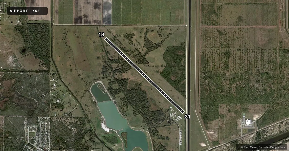
Airport sketch
Runways drawn to scale from FAA survey coordinates, rendered over satellite imagery. Not for navigation.
Approaches & charts
Services on the field
Fuel grades, oxygen, maintenance, ramp storage and lighting — as declared to the FAA by the airport operator.
Fuel & services
- Fuel
- 100LL
- Oxygen (bottled)
- Not available
- Oxygen (bulk)
- Not available
- Airframe repair
- Major
- Power plant repair
- Major
- Other services
- AGRI,INSTR
Ramp & ground
- Transient storage
- Tie-down
- Hangar
- Landing fee
- Yes
- Customs
- Not available
- Wind indicator
- Yes
- Segmented circle
- No
Fuel & FBOs
Cheapest 100LL and Jet A on the field and nearby. Always confirm with the FBO before taxi.
Airport notes
Surface conditions, obstructions, local procedures, lighting outages and other notes published with each FAA cycle.
General notes
- STANDING WATER AT RY EDGES AFTER RAIN.
- PPR FOR TSNT ACFT TRNG CALL 772-597-5800
- LANDING FEE CURRENTLY IN EFFECT.
- $10 LANDING FEE WAIVED WITH FUEL PURCHASE.
- NO TOUCH AND GO LNDGS.
- ARPT CLSD EXC TO POWERED F/W ACFT.
- FOR CD CTC PALM BEACH APCH AT 561-684-9047.
Fuel notes
- 100LLFUEL AVBL WITH MC & VISA CREDIT CARD ONLY.
Approach & departure obstructions
- 13RWY 13 /31 DTHR & RWY SIDES MKD WITH W PAVING STONES AND W PVC MARKERS.
Other notes
- VFR OPERNS ONLY.
- MANAGERAPT PHYS ADS: 20654 SOUTHWEST CITRUS BOULEVARD, INDIANTOWN FL 34956.
- OWNERCONTACT PERSON: CLYDE DAWSON
VFR map & nearby airports
VFR sectional. Tap any ICAO chip to open that airport.
Key facts · X58
Answer card- ICAO
- X58
- Name
- INDIANTOWN
- Location
- INDIANTOWN, FLORIDA
- Elevation
- 30 ft MSL
- Traffic pattern altitude
- 1,030 ft MSL (1,000 AGL)
- Control tower
- Non-towered (use CTAF)
- Total runways
- 1
- Longest runway
- 13/31 · 6,300 ft
- Published ILS approaches
- 0
- Published frequencies
- 2
- Magnetic variation
- 3°
- Current flight rules
- VFR
- Current wind
- 300° at 6 kt
- Favored runway now
- RWY 31
Indiantown Airport (X58) sits in Indiantown, Florida. Field elevation is 30 ft MSL. The airport has one runway. Runway 13/31 is 6,300 ft of turf, which gives you plenty of length for light aircraft operations. This is a non-towered field. CTAF and UNICOM are both 123.0. No ILS approaches are published here.
Pattern altitude is not published. Use the standard 1,000 ft AGL pattern unless local guidance says otherwise. The published remarks say this is VFR only. The airport is closed except to powered fixed-wing aircraft. There is also no touch and go traffic allowed. Prior permission is required for transient aircraft training. Call 772-597-5800 before you plan that kind of operation.
Fuel is available with MasterCard and Visa credit cards only. The published remarks also note a landing fee that is currently in effect. That fee is waived with a fuel purchase. Runway 13/31 has a displaced threshold. The runway sides are marked with white paving stones and white PVC markers. Standing water can collect at the runway edges after rain, so plan your rollout and taxi with that in mind. For clearance delivery, contact Palm Beach Approach at 561-684-9047. No on-field FBOs are listed.