METAR & TAF KOBE
Current METAR
Observed 03:35Z
KOBE 240335Z AUTO 22008KT 10SM FEW048 SCT065 28/25 A3010 RMK AO2 LTG DSNT E
- Wind
- 220° @ 8 kt
- Visibility
- 10 SM
- Temp / Dew
- 28°C / 25°C
- Altimeter
- 30.10 inHg
- Clouds
- SCT
- Density alt
- 1,378 ft
- Ceiling
- Unlimited
- Rules
- VFR
Airport info & contacts
Manager on record, flight service, ARTCC, attendance schedule and pattern altitude — published by the FAA and refreshed every 28 days.
Location
- From city
- 3 NM NW
- VFR sectional
- MIAMI
- ARTCC
- ZMA · MIAMI
- NOTAM facility
- PIE (NOTAM-D)
Airport manager
- Name
- CHRISTOPHER GEORGES
- Phone
- 863-467-5505
- Address
- 2800 NW 20TH TRL, OKEECHOBEE FL 34972
Flight service · Hours
- FSS PIE
- SAINT PETERSBURG1-800-WX-BRIEF
- Attendance
- 0800-1700
Frequencies
Tap any row to copy the frequency to your clipboard.
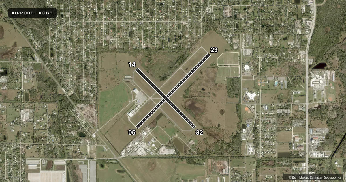
Runways & pattern
Full pagePattern entry · RWY 23
LEFT TRAFFIC| Runway | Heading (°M) | Length | Surface | Traffic |
|---|---|---|---|---|
| 05/23Favored | 39° / 219° | 5,000 ft | ASPH | Standard L |
| 14/32 | 129° / 309° | 4,001 ft | ASPH | Standard L |
Runway end performance
| End | TORA | TODA | ASDA | LDA | VGSI | Approach lights | Obstruction |
|---|---|---|---|---|---|---|---|
| 05 | — | — | — | — | PAPI 4-box left(3°) | — | 43', trees, 1920' from thr, 300' R of cntrln, slope 40 |
| 23 | — | — | — | — | PAPI 4-box left(3°) | — | 43', trees, 1430' from thr, 195' R of cntrln, slope 28 |
| 14 | — | — | — | — | PAPI 4-box left(3°) | — | 34', trees, 1060' from thr, 175' R of cntrln, slope 25 |
| 32 | — | — | — | — | PAPI 4-box left(3°) | — | 5', fence, 200' from thr, 215' R of cntrln, slope 0 |
Declared distances in feet. TORA = takeoff run available, TODA = takeoff distance, ASDA = accelerate-stop, LDA = landing distance.
Airport sketch
Runways drawn to scale from FAA survey coordinates, rendered over satellite imagery. Not for navigation.
Approaches & charts
Services on the field
Fuel grades, oxygen, maintenance, ramp storage and lighting — as declared to the FAA by the airport operator.
Fuel & services
- Fuel
- 100LLAA+
- Oxygen (bottled)
- Not available
- Oxygen (bulk)
- Not available
- Airframe repair
- Minor
- Power plant repair
- Minor
- Other services
- INSTR
Ramp & ground
- Transient storage
- Tie-down
- Landing fee
- No fee published
- Customs
- Not available
- Lighting schedule
- SEE RMK
- Beacon schedule
- SS-SR
- Beacon
- White / Green (civil land)(WG)
- Wind indicator
- Lighted
Fuel & FBOs
Cheapest 100LL and Jet A on the field and nearby. Always confirm with the FBO before taxi.
Airport notes
Surface conditions, obstructions, local procedures, lighting outages and other notes published with each FAA cycle.
General notes
- FBO PHONE IS 863-467-5505.
- NON-POWERED FLT WI TFC PAT NA.
- TKOF & LNDG ON GRASS AT OWN RISK.
- FOR CD CTC MIAMI ARTCC AT 305-716-1731.
- APRON PCR VALUE: 203/F/A/X/T
- TWY A PCR VALUE: 378/F/A/X/T
Lighting notes
- ACTVT REIL RWY 05 & 23; MIRL RWY 05/23, - CTAF
Runway surface & condition
- 05/23PCR VALUE: 218/F/A/X/T
- 14/32PCR VALUE: 192/F/A/X/T
Approach & departure obstructions
- 325 FT FENCE 200FT FM RWY END 215 FT L.
- 05CALM WIND RWY.
- 14CTLG OBSTN EXCEEDS A 45 DEG SLP.
Other notes
- VFR OPS ONLY.
- 1UNATNDD CHRISTMAS AND THANKSGIVING.
- 1AFT HRS CALL 863-657-8761
- OWNERCONTACT PERSON: DEBORAH MANZO 863-763-6441
- MANAGEREMERGENCY CELL PHONE 863-634-1474
VFR map & nearby airports
VFR sectional. Tap any ICAO chip to open that airport.
Key facts · KOBE
Answer card- ICAO
- KOBE
- Name
- OKEECHOBEE COUNTY
- Location
- OKEECHOBEE, FLORIDA
- Elevation
- 33.5 ft MSL
- Traffic pattern altitude
- 1,033.5 ft MSL (1,000 AGL)
- Control tower
- Non-towered (use CTAF)
- Total runways
- 2
- Longest runway
- 05/23 · 5,000 ft
- Published ILS approaches
- 0
- Published frequencies
- 2
- Magnetic variation
- 6°
- Current flight rules
- VFR
- Current wind
- 220° at 8 kt
- Favored runway now
- RWY 23
Okeechobee County Airport sits in Okeechobee, Florida. Field elevation is 33.5 ft MSL. The airport has two asphalt runways. The longest is runway 05/23 at 5,000 ft. This is a non-towered field. CTAF and UNICOM are both 123.0.
No ILS approaches are published here. The field is VFR only per the published remarks. Pattern altitude is not published, so use the standard 1,000 ft AGL for light piston traffic unless the current Chart Supplement says otherwise. The airport also notes that non-powered flight within the traffic pattern is not authorized.
On the field, Okeechobee County Airport FBO carries 100LL, Jet A and Jet A Prist. The published remarks also note that runway 05 is the calm wind runway. Runway 05 and 23 have runway end identifier lights. Runway 05/23 also has medium intensity runway lights. If you are planning runway 14 or 32, pay attention to the published obstruction notes. Runway 14 has a cataloged obstruction that exceeds a 45 degree slope. Runway 32 has a 5 ft fence near the departure end, offset to the left. For any current operational detail, check the current FAA Chart Supplement or call the airport operator or FBO directly.