METAR & TAF KVRB
Current METAR
Observed 14:56Z
KVRB 271456Z 28007KT 260V320 10SM BKN022 32/25 A2993 RMK AO2 T03170250
- Wind
- 280° @ 7 kt
- Visibility
- 10 SM
- Temp / Dew
- 32°C / 25°C
- Altimeter
- 29.93 inHg
- Clouds
- BKN
- Density alt
- 2,057 ft
- Ceiling
- 2,200 ft AGL
- Rules
- MVFR
Airport info & contacts
Manager on record, flight service, ARTCC, attendance schedule and pattern altitude — published by the FAA and refreshed every 28 days.
Location
- From city
- 1 NM NW
- VFR sectional
- MIAMI
- ARTCC
- ZMA · MIAMI
- NOTAM facility
- VRB (NOTAM-D)
Airport manager
- Name
- TODD SCHER
- Phone
- 772-978-4930
- Address
- 3400 CHEROKEE DRIVE, VERO BEACH FL 32960-1389
Flight service · Hours
- FSS PIE
- SAINT PETERSBURG1-800-WX-BRIEF
- Attendance
- 0600-2300
Frequencies
Tap any row to copy the frequency to your clipboard.
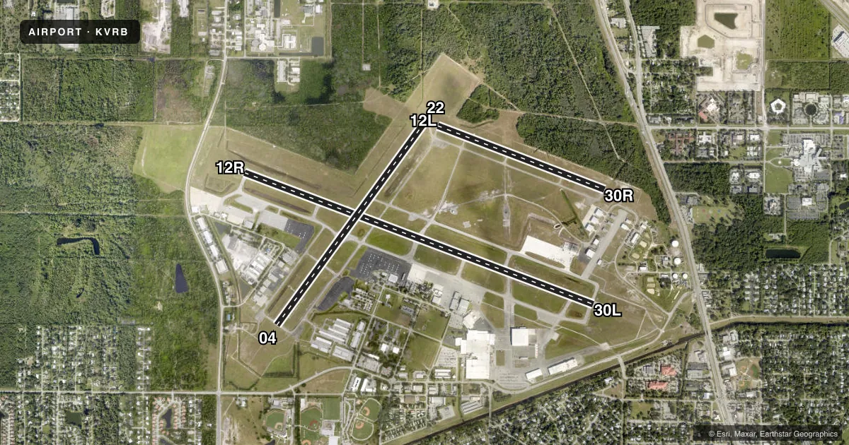
Runways & pattern
Full pagePattern entry · RWY 30L
LEFT TRAFFIC| Runway | Heading (°M) | Length | Surface | Traffic |
|---|---|---|---|---|
| 12R/30LFavored | 104° / 284° | 7,314 ft | ASPH | 12R R |
| 04/22 | 29° / 209° | 4,974 ft | ASPH | Standard L |
| 12L/30R | 104° / 284° | 3,505 ft | ASPH | 30R R |
Runway end performance
| End | TORA | TODA | ASDA | LDA | VGSI | Approach lights | Obstruction |
|---|---|---|---|---|---|---|---|
| 12R | 7,314' | 7,314' | 7,314' | 7,314' | PAPI 4-box left(3°) | — | 66', trees, 2790' from thr, 30' R of cntrln, slope 39 |
| 30L | 7,314' | 7,314' | 7,276' | 7,276' | PAPI 4-box left(3°) | — | 40', trees, 1965' from thr, 315' R of cntrln, slope 44 |
| 04 | 4,974' | 4,974' | 4,974' | 4,974' | PAPI 4-box left(3°) | — | 35', trees, 1395' from thr, 250' R of cntrln, slope 34 |
| 22 | 4,974' | 4,974' | 4,945' | 4,945' | PAPI 4-box left(3°) | — | 55', trees, 2070' from thr, 80' R of cntrln, slope 34 |
| 12L | 3,505' | 3,505' | 3,505' | 3,505' | PAPI 2-box left(3°) | — | 51', trees, 1630' from thr, 135' R of cntrln, slope 28 |
| 30R | 3,505' | 3,505' | 3,505' | 3,505' | PAPI 2-box left(3.5°) | — | 35', trees, 1120' from thr, 80' R of cntrln, slope 26 |
Declared distances in feet. TORA = takeoff run available, TODA = takeoff distance, ASDA = accelerate-stop, LDA = landing distance.
Airport sketch
Runways drawn to scale from FAA survey coordinates, rendered over satellite imagery. Not for navigation.
Approaches & charts
Services on the field
Fuel grades, oxygen, maintenance, ramp storage and lighting — as declared to the FAA by the airport operator.
Fuel & services
- Fuel
- 100A
- Oxygen (bottled)
- HIGH/LOW
- Oxygen (bulk)
- Not available
- Airframe repair
- Major
- Power plant repair
- Major
- Other services
- AFRT,AMB,AVNCS,CHTR,INSTR,RNTL,SALES
Ramp & ground
- Transient storage
- Tie-down
- Hangar
- Landing fee
- No fee published
- Customs
- Not available
- Lighting schedule
- SEE RMK
- Beacon schedule
- SS-SR
- Beacon
- White / Green (civil land)(WG)
- Wind indicator
- Lighted
- Segmented circle
- Yes
Fuel & FBOs
Cheapest 100LL and Jet A on the field and nearby. Always confirm with the FBO before taxi.
Airport notes
Surface conditions, obstructions, local procedures, lighting outages and other notes published with each FAA cycle.
General notes
- FLT TRNG ON & INVOF ARPT.
- NOISE SENSITIVE ARPT; JET ACFT USE NATL BUS ACFT ASSOCIATION NOISE ABATEMENT PROC.
- VOLUNTARY LOCAL NOISE ABATEMENT PROC IN EFCT - AMGR.
- INT DEP NA EXC BY ATC REQUEST.
- RSCD NOT MNT 2300-0600 M-F 1530-0600 WKEND AND HOL.
- FOR CD IF UNA TO CTC ON FSS FREQ, CTC PALM BEACH APCH AT 561-275-1430.
- TWY B & F OPS FOR ACFT WITH WINGSPAN OF MORE THAN 79 FT AT PILOTS DISCRETION - AMGR.
- GLDR OPS INVOF X52 ARPT APRXLY 8 NM WSW.
- 24 HR PPR FOR ACFT EQUIPPED WITH WEATHER MODIFAICATION OR GEOENGINEERING EQPT 772-978-4930.
Lighting notes
- WHEN ATCT CLSD, ACTVT REIL RWY 04, 12R, 22 & 30L; PAPI RWY 4, 12R, 12L, 22, 30R & 30L; MIRL RWY 4/22, 12R/30L, 12L/30R - CTAF
Runway surface & condition
- 04/22PCR VALUE: 350/F/A/X/T
- 12L/30RPCR VALUE: 150/F/B/X/T
- 12R/30LPCR VALUE: 450/F/B/X/T
- 04/22RWY 04/22 NOT AVBL FOR PART 121/PART 380 OPS WITH SKED PAX CARRYING OPS MORE THAN 9 PAX SEATS AND NON-SKED PAX CARRYING OPS MORE THAN 30 PAX SEATS.
- 12L/30RRWY 12L/30R NOT AVBL FOR PART 121/PART 380 OPS WITH SKED PAX CARRYING OPS MORE THAN 9 PAX SEATS AND NON-SKED PAX CARRYING OPS MORE THAN 30 PAX SEATS.
Other notes
- CLSD TO UNSKED ACR OPS WITH MORE THAN 30 PAX SEATS; 24 HR PPR REQ - AMGR.
- MANAGEREXT 104.
VFR map & nearby airports
VFR sectional. Tap any ICAO chip to open that airport.
Key facts · KVRB
Answer card- ICAO
- KVRB
- Name
- VERO BEACH RGNL
- Location
- VERO BEACH, FLORIDA
- Elevation
- 23.7 ft MSL
- Traffic pattern altitude
- 1,023.7 ft MSL (1,000 AGL)
- Control tower
- Towered · 0700-0100
- Total runways
- 3
- Longest runway
- 12R/30L · 7,314 ft
- Published ILS approaches
- 0
- Published frequencies
- 9
- Magnetic variation
- 7°
- Current flight rules
- MVFR
- Current wind
- 280° at 7 kt
- Favored runway now
- RWY 30L
Vero Beach Rgnl is in Vero Beach, Florida. The field elevation is 23.7 ft MSL. It has 3 asphalt runways. The longest is 7,314 ft on 12R/30L. The tower is open 0700-0100. No ILS approaches are published, so plan with that in mind if the weather is marginal.
Pattern altitude is not published. Use the standard 1,000 ft AGL for light piston traffic unless ATC or the current Chart Supplement says otherwise. The airport is noise sensitive. Jet aircraft are expected to use NBAA noise abatement procedures. A voluntary local noise abatement procedure is also in effect. Flight training is conducted on and near the airport, so expect busy local traffic.
On the field, Corporate Air carries 100LL and Jet A. Paris Air carries 100LL. Sun Aviation carries 100LL and Jet A Prist. If you need current ramp or service details, call the FBO directly before arrival.
A few operational notes matter here. Intersection departures are not authorized unless ATC requests them. Taxiways B and F are at pilot discretion for aircraft with wingspans over 79 ft, with airport manager approval. Runway 04/22 and runway 12L/30R both have published use limits for some Part 121 and Part 380 operations. If you are flying a larger aircraft or a scheduled operation, verify the current Chart Supplement and coordinate with the airport manager before you go.