METAR & TAF X26
Current METAR
Observed 14:55Z
KX26 271455Z AUTO 29005KT 10SM FEW024 31/27 A2992 RMK AO2
- Wind
- 290° @ 5 kt
- Visibility
- 10 SM
- Temp / Dew
- 31°C / 27°C
- Altimeter
- 29.92 inHg
- Clouds
- FEW
- Density alt
- 1,947 ft
- Ceiling
- Unlimited
- Rules
- VFR
Airport info & contacts
Manager on record, flight service, ARTCC, attendance schedule and pattern altitude — published by the FAA and refreshed every 28 days.
Location
- From city
- 1 NM W
- VFR sectional
- MIAMI
- ARTCC
- ZMA · MIAMI
- NOTAM facility
- PIE (NOTAM-D)
Airport manager
- Name
- JEFFREY SABO
- Phone
- 772-228-7013
- Address
- 202 AIRPORT DRIVE EAST, SEBASTIAN FL 32958
Flight service · Hours
- FSS PIE
- SAINT PETERSBURG1-800-WX-BRIEF
- Attendance
- MON-FRI · 0800-1700
Frequencies
Tap any row to copy the frequency to your clipboard.
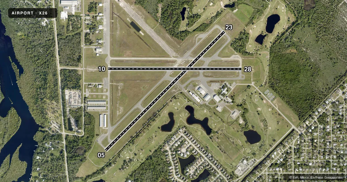
Runways & pattern
Full pagePattern entry · RWY 28
RIGHT TRAFFIC| Runway | Heading (°M) | Length | Surface | Traffic |
|---|---|---|---|---|
| 05/23 | 39° / 219° | 4,023 ft | ASPH | 23 R |
| 10/28Favored | 84° / 264° | 3,199 ft | ASPH | 28 R |
Runway end performance
| End | TORA | TODA | ASDA | LDA | VGSI | Approach lights | Obstruction |
|---|---|---|---|---|---|---|---|
| 05 | — | — | — | — | PAPI 2-box left | — | 37', trees, 1090' from thr, 120' R of cntrln, slope 24 |
| 23 | — | — | — | — | PAPI 2-box left | — | 45', trees, 1520' from thr, 135' R of cntrln, slope 29 |
| 10 | — | — | — | — | PAPI 2-box left | — | 29', trees, 735' from thr, 125' R of cntrln, slope 18 |
| 28 | — | — | — | — | PAPI 2-box left | — | 20', trees, 665' from thr, 65' R of cntrln, slope 23 |
Declared distances in feet. TORA = takeoff run available, TODA = takeoff distance, ASDA = accelerate-stop, LDA = landing distance.
Airport sketch
Runways drawn to scale from FAA survey coordinates, rendered over satellite imagery. Not for navigation.
Approaches & charts
Services on the field
Fuel grades, oxygen, maintenance, ramp storage and lighting — as declared to the FAA by the airport operator.
Fuel & services
- Fuel
- 100LL
- Oxygen (bottled)
- Not available
- Oxygen (bulk)
- Not available
- Airframe repair
- Minor
- Power plant repair
- Minor
- Other services
- CHTR,INSTR,PAJA,RNTL
Ramp & ground
- Transient storage
- Tie-down
- Landing fee
- No fee published
- Customs
- Not available
- Lighting schedule
- SEE RMK
- Beacon schedule
- SS-SR
- Beacon
- White / Green (civil land)(WG)
- Wind indicator
- Lighted
Fuel & FBOs
Cheapest 100LL and Jet A on the field and nearby. Always confirm with the FBO before taxi.
Airport notes
Surface conditions, obstructions, local procedures, lighting outages and other notes published with each FAA cycle.
General notes
- TREES & BRUSH IN ALL TRSN SFCS RWY 5/23.
- NOISE ABATEMENT PROCS IN EFCT: CTC AMGR 772-633-0897.
- IDENTIFICATION RQR FOR ARPT ACCESS.
- EXTSV PRCHT OPNS. AVOID OVERFLYING ARPT DURG PRCHT OPNS.
- FOR CD CTC PALM BEACH APCH AT 561-275-1430
Lighting notes
- PAPI OPRS CONSLY. ACTVT REIL RWY 5 & 23; MIRL RWY 5/23 - CTAF.
Fuel notes
- 100LLFUEL 24 HR CREDIT CARD SVC AVBL.
Approach & departure obstructions
- 10RWY 10 APRCH SLOPE 24:1 TO AER.
Other notes
- EXISTED PRIOR TO 1959.
- OWNERCTC PERSON: BRIAN BENTON 772-638-8820
VFR map & nearby airports
VFR sectional. Tap any ICAO chip to open that airport.
Key facts · X26
Answer card- ICAO
- X26
- Name
- SEBASTIAN MUNI
- Location
- SEBASTIAN, FLORIDA
- Elevation
- 21.5 ft MSL
- Traffic pattern altitude
- 1,021.5 ft MSL (1,000 AGL)
- Control tower
- Non-towered (use CTAF)
- Total runways
- 2
- Longest runway
- 05/23 · 4,023 ft
- Published ILS approaches
- 0
- Published frequencies
- 3
- Magnetic variation
- 6°
- Current flight rules
- VFR
- Current wind
- 290° at 5 kt
- Favored runway now
- RWY 28
Sebastian Muni is in Sebastian, Florida. The field elevation is 21.5 ft MSL. It has two asphalt runways. The longest is 4,023 ft on runway 05/23. There is no control tower. Published traffic pattern altitude is not listed, so use the standard 1,000 ft AGL for light piston traffic unless the current Chart Supplement says otherwise.
No ILS approaches are published here. The airport sits in the Miami ARTCC area with CTAF on 123.05. Published remarks call out noise abatement procedures, so check the current Chart Supplement and brief them before arrival. The field also has extensive parachute operations. Avoid overflying the airport when those ops are active. Trees and brush are present in the transitional surfaces for runway 05/23, so pay attention to your departure and arrival profile.
On the field, SkyBlue Jet Aviation carries 100LL and Jet A. Wings Airline Academy carries 100LL. Fuel with 24-hour credit card service is available. The runway lighting for 05 and 23 is activated on CTAF. PAPI runs continuously. Runway end identifier lights are also published for 05 and 23. For clearance delivery, contact Palm Beach Approach. First-time arrivals should also note that airport access requires identification.