METAR & TAF 2RR
2RR does not publish a METAR.
Showing the nearest reporting station: KSEF (SEBRING RGNL) · 20.7 NM away. Conditions at 2RR may differ.
METAR · KSEF
Observed 13:35Z
KSEF 271335Z AUTO 31011KT 10SM CLR 30/26 A2995 RMK AO2 T03040260
- Wind
- 310° @ 11 kt
- Visibility
- 10 SM
- Temp / Dew
- 30°C / 26°C
- Altimeter
- 29.95 inHg
- Clouds
- CLR
- Density alt
- 1,831 ft
- Ceiling
- Unlimited
- Rules
- VFR
Airport info & contacts
Manager on record, flight service, ARTCC, attendance schedule and pattern altitude — published by the FAA and refreshed every 28 days.
Location
- From city
- 0 NM NW
- VFR sectional
- MIAMI
- ARTCC
- ZMA · MIAMI
- NOTAM facility
- PIE (NOTAM-D)
Airport manager
- Name
- DAVID SMITH
- Phone
- 863-692-1321
- Address
- 3200 RIVER RANCH BLVD, RIVER RANCH FL 33867-0030
Flight service · Hours
- FSS PIE
- SAINT PETERSBURG1-800-WX-BRIEF
- Attendance
- ALL
Frequencies
Tap any row to copy the frequency to your clipboard.
Runways & pattern
Full pagePattern entry · RWY 34
RIGHT TRAFFICRunway end performance
| End | TORA | TODA | ASDA | LDA | VGSI | Approach lights | Obstruction |
|---|---|---|---|---|---|---|---|
| 16 | — | — | — | — | — | — | 35', trees, 310' from thr, 110' R of cntrln, slope 3 |
| 34 | — | — | — | — | — | — | 44', tree, 330' from thr, 70' R of cntrln, slope 2 |
Declared distances in feet. TORA = takeoff run available, TODA = takeoff distance, ASDA = accelerate-stop, LDA = landing distance.
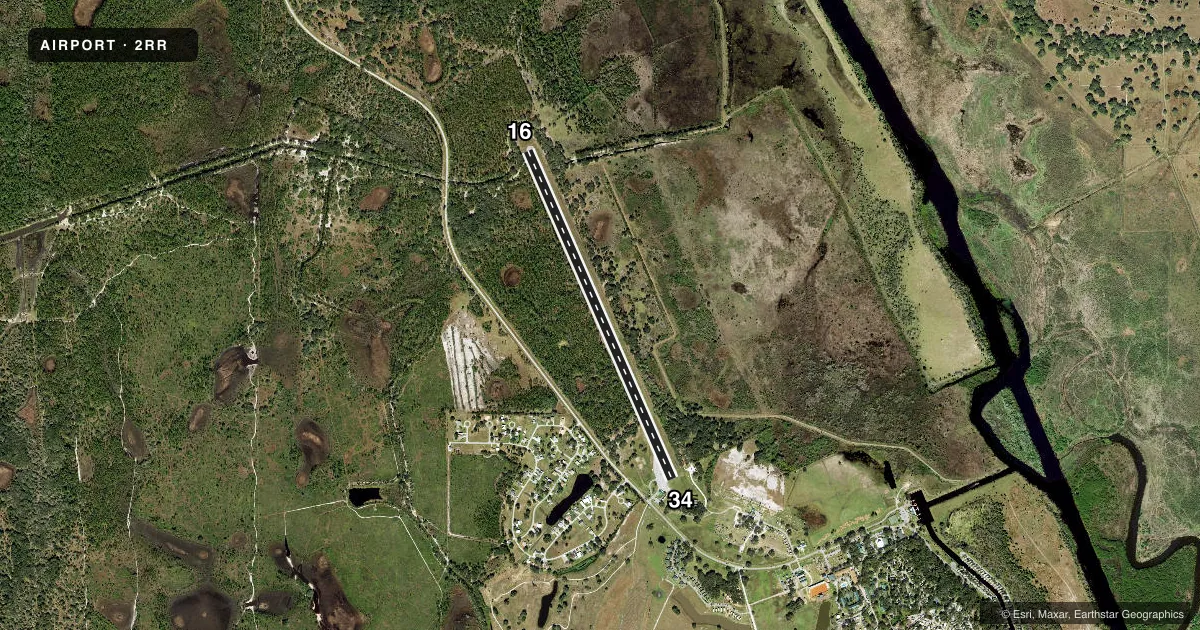
Airport sketch
Runways drawn to scale from FAA survey coordinates, rendered over satellite imagery. Not for navigation.
Approaches & charts
Services on the field
Fuel grades, oxygen, maintenance, ramp storage and lighting — as declared to the FAA by the airport operator.
Fuel & services
- Fuel
- Not available
- Airframe repair
- Not available
- Power plant repair
- Not available
Ramp & ground
- Transient storage
- Tie-down
- Landing fee
- No fee published
- Lighting schedule
- SEE RMK
- Beacon schedule
- SEE RMK
- Beacon
- White / Green (civil land)(WG)
- Wind indicator
- Lighted
- Segmented circle
- No
Fuel & FBOs
Cheapest 100LL and Jet A on the field and nearby. Always confirm with the FBO before taxi.
Airport notes
Surface conditions, obstructions, local procedures, lighting outages and other notes published with each FAA cycle.
General notes
- RWY 34 250' TOWER E 3000' SE OF RWY END E 2400' RT OF CL.
- 30 FT BRUSH & TREES 125 FT FROM CNTRLN BOTH SIDES OF RY.
- FOR CD CTC MIAMI ARTCC AT 305-716-1731.
- UNLGTD OBSTNS, TREES 120 FT LEFT OF CNTRLN & 315 FT BFR AER RWY 16.
- RSA HAS STANDING WATER AFTER HEAVY RAIN EVENTS.
Lighting notes
- RDO-CTL
- ACTVT LIRL RWY 16/34 - CTAF.
Approach & departure obstructions
- 16RWY 16/34 MARKINGS FADED.
- 34RWY 16/34 MARKINGS FADED.
- 16RY 16/34 THLD MARKINGS HAVE INCORRECT SPACING.
- 16RWY 16 APCH SLOPE 17:1 DUE TO 48 FT TREE 600 FT FM RWY END 40 FT LEFT.
- 34RWY 34 APCH SLOPE 30:1 TO DTHR.
Other notes
- VFR OPERATIONS ONLY.
- 16/34RWY 16/34 HAS WDSPR CRACKING AND PRODUCING LOOSE AGGREGATE.
VFR map & nearby airports
VFR sectional. Tap any ICAO chip to open that airport.
Key facts · 2RR
Answer card- ICAO
- 2RR
- Name
- RIVER RANCH RESORT
- Location
- RIVER RANCH, FLORIDA
- Elevation
- 55 ft MSL
- Traffic pattern altitude
- 1,055 ft MSL (1,000 AGL)
- Control tower
- Non-towered (use CTAF)
- Total runways
- 1
- Longest runway
- 16/34 · 4,950 ft
- Published ILS approaches
- 0
- Published frequencies
- 2
- Magnetic variation
- 3°
- Current flight rules
- VFR
- Current wind
- 310° at 11 kt
- Favored runway now
- RWY 34
River Ranch Resort Airport (2RR) sits in River Ranch, Florida. The field elevation is 55 ft MSL. It has one runway. Runway 16/34 is 4,950 ft of asphalt, which is the longest runway on the field. There is no control tower. CTAF and UNICOM are both 122.8.
No ILS approaches are published here. The published pattern altitude is not listed, so use the standard 1,000 ft AGL for light piston traffic unless the current Chart Supplement says otherwise. This is a VFR-only airport, so plan your arrival and departure with that in mind. Westgate River Ranch is on the field. It carries 100LL.
The remarks matter here. There is a 250-foot tower southeast of the runway environment. There are also trees and brush close to the runway centerline. Runway 16 has a steep approach path because of a tree near the approach end. Runway 34 also has a displaced-threshold approach path. Markings are faded. The threshold markings have incorrect spacing. The runway safety area can hold standing water after heavy rain. If you need clearance delivery, contact Miami ARTCC. First-time pilots should review the current Chart Supplement before going in. Pay close attention to the obstacles, the VFR-only status and the lack of published instrument approaches.