METAR & TAF X07
X07 does not publish a METAR.
Showing the nearest reporting station: KBOW (BARTOW EXEC) · 9.1 NM away. Conditions at X07 may differ.
METAR · KBOW
Observed 11:55Z
KBOW 271155Z AUTO 27006KT 10SM VCTS FEW023 FEW029 26/26 A2994 RMK AO2 LTG DSNT S PWINO
- Wind
- 270° @ 6 kt
- Visibility
- 10 SM
- Temp / Dew
- 26°C / 26°C
- Altimeter
- 29.94 inHg
- Clouds
- FEW
- Density alt
- 1,452 ft
- Ceiling
- Unlimited
- Rules
- VFR
Airport info & contacts
Manager on record, flight service, ARTCC, attendance schedule and pattern altitude — published by the FAA and refreshed every 28 days.
Location
- From city
- 2 NM W
- VFR sectional
- MIAMI
- ARTCC
- ZMA · MIAMI
- NOTAM facility
- PIE (NOTAM-D)
Airport manager
- Name
- AMANDA LOMNECK
- Phone
- 863-678-0080
- Address
- 450 SOUTH AIRPORT RD, LAKE WALES FL 33859-1320
Flight service · Hours
- FSS PIE
- SAINT PETERSBURG1-800-WX-BRIEF
- Attendance
- 0800-1700
Frequencies
Tap any row to copy the frequency to your clipboard.
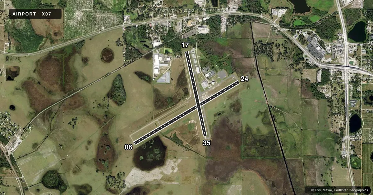
Runways & pattern
Full pagePattern entry · RWY 24
LEFT TRAFFIC| Runway | Heading (°M) | Length | Surface | Traffic |
|---|---|---|---|---|
| 06/24Favored | 52° / 232° | 5,400 ft | ASPH | Standard L |
| 17/35 | 160° / 340° | 3,860 ft | ASPH | Standard L |
Runway end performance
| End | TORA | TODA | ASDA | LDA | VGSI | Approach lights | Obstruction |
|---|---|---|---|---|---|---|---|
| 06 | — | — | — | — | PAPI 4-box left(3.5°) | — | 36', trees, 1305' from thr, 300' R of cntrln, slope 31 |
| 24 | — | — | — | — | PAPI 4-box left(3.5°) | — | 51', trees, 1770' from thr, 165' R of cntrln, slope 31 |
| 17 | — | — | — | — | PAPI 2-box right(3.37°) | — | 18', trees, 410' from thr, 125' R of cntrln, slope 11 |
| 35 | — | — | — | — | PAPI 2-box left(3°) | — | — |
Declared distances in feet. TORA = takeoff run available, TODA = takeoff distance, ASDA = accelerate-stop, LDA = landing distance.
Airport sketch
Runways drawn to scale from FAA survey coordinates, rendered over satellite imagery. Not for navigation.
Approaches & charts
Services on the field
Fuel grades, oxygen, maintenance, ramp storage and lighting — as declared to the FAA by the airport operator.
Fuel & services
- Fuel
- 100LLA
- Oxygen (bottled)
- Not available
- Oxygen (bulk)
- Not available
- Airframe repair
- Not available
- Power plant repair
- Not available
- Other services
- PAJA
Ramp & ground
- Transient storage
- Tie-down
- Landing fee
- No fee published
- Customs
- Not available
- Lighting schedule
- SEE RMK
- Beacon schedule
- SS-SR
- Beacon
- White / Green (civil land)(WG)
- Wind indicator
- Lighted
Fuel & FBOs
Cheapest 100LL and Jet A on the field and nearby. Always confirm with the FBO before taxi.
Airport notes
Surface conditions, obstructions, local procedures, lighting outages and other notes published with each FAA cycle.
General notes
- ULTRALIGHT ACTIVITY ON & INVOF ARPT.
- TREES IN TRANSITIONAL SFC RY 17; APCH WEST OF RY.
- FOR CD CTC MIAMI ARTCC AT 305-716-1731.
Lighting notes
- ACTVT REIL RWY 6 & 24; PAPI RWY 17 & 35; MIRL RWY 6/ 24 - CTAF. PAPI 6 & 24 OPR CONSLY.
Fuel notes
- 100LLFUEL AVBL 24 HR CREDIT CARD SVC.
Other notes
- EXISTED PRIOR TO 1959.
- OWNERCONTACT PERSON: JAMES SLATON
VFR map & nearby airports
VFR sectional. Tap any ICAO chip to open that airport.
Key facts · X07
Answer card- ICAO
- X07
- Name
- LAKE WALES MUNI
- Location
- LAKE WALES, FLORIDA
- Elevation
- 126.7 ft MSL
- Traffic pattern altitude
- 1,126.7 ft MSL (1,000 AGL)
- Control tower
- Non-towered (use CTAF)
- Total runways
- 2
- Longest runway
- 06/24 · 5,400 ft
- Published ILS approaches
- 0
- Published frequencies
- 2
- Magnetic variation
- 7°
- Current flight rules
- VFR
- Current wind
- 270° at 6 kt
- Favored runway now
- RWY 24
Lake Wales Muni is in Lake Wales, Florida. The field elevation is 126.7 ft MSL. It has two asphalt runways. Runway 06/24 is the longest at 5,400 ft. Runway 17/35 is 3,860 ft. There is no control tower. CTAF and UNICOM are both 122.8.
No ILS approaches are published here. The published pattern altitude is not listed, so use the standard 1,000 ft AGL for light piston traffic unless the current Chart Supplement says otherwise. The on-field FBO is Lake Wales Municipal Airport. It carries 100LL and Jet A. Fuel is available 24 hours with credit card service. The airport contact person is James Slaton.
A few operational points matter here. Runway 6 and 24 have runway end identifier lights. Runways 6 and 24 also have medium intensity runway lights that are controlled on CTAF. PAPI is installed on runways 17 and 35. Trees are in the transitional surface for runway 17. The approach is west of that runway. Ultralight activity also occurs on and near the airport, so keep your scan sharp in the pattern and on taxi. For clearance delivery, contact Miami ARTCC. If you need current noise or local operating limits, check the current FAA Chart Supplement before you go.