METAR & TAF KBOW
Current METAR
Observed 13:35Z
KBOW 271335Z AUTO 32006KT 10SM CLR 27/23 A2995 RMK AO2 LTG DSNT W AND NW PWINO
- Wind
- 320° @ 6 kt
- Visibility
- 10 SM
- Temp / Dew
- 27°C / 23°C
- Altimeter
- 29.95 inHg
- Clouds
- CLR
- Density alt
- 1,557 ft
- Ceiling
- Unlimited
- Rules
- VFR
Airport info & contacts
Manager on record, flight service, ARTCC, attendance schedule and pattern altitude — published by the FAA and refreshed every 28 days.
Location
- From city
- 4 NM NE
- VFR sectional
- MIAMI
- ARTCC
- ZMA · MIAMI
- NOTAM facility
- BOW (NOTAM-D)
Airport manager
- Name
- JOHN B. HELMS, II
- Phone
- 863-533-1195
- Address
- 5993 AIRPORT BLVD, BARTOW FL 33830
Flight service · Hours
- FSS PIE
- SAINT PETERSBURG1-800-WX-BRIEF
- Attendance
- 0600-1800
Frequencies
Tap any row to copy the frequency to your clipboard.
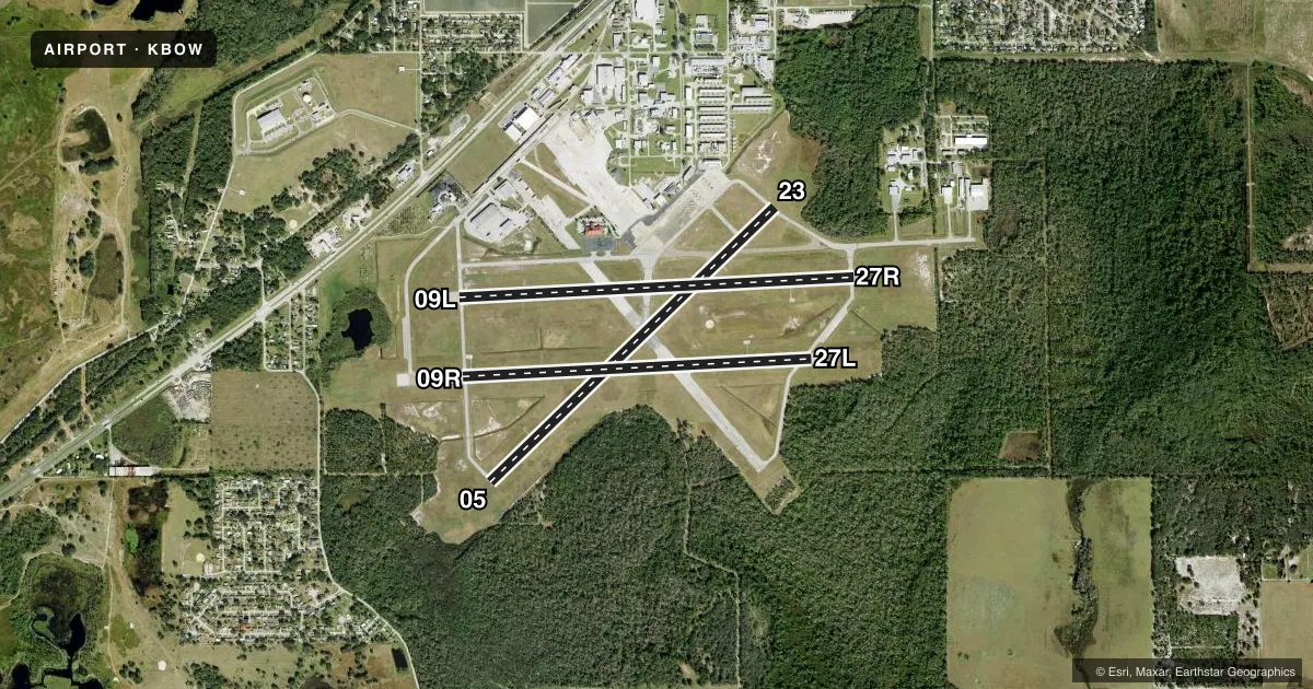
Runways & pattern
Full pagePattern entry · RWY 27R
RIGHT TRAFFIC| Runway | Heading (°M) | Length | Surface | Traffic |
|---|---|---|---|---|
| 05/23 | 42° / 222° | 5,001 ft | ASPH | Standard L |
| 09L/27RFavored | 83° / 263° | 5,000 ft | ASPH | 27R R |
| 09R/27L | 83° / 263° | 4,416 ft | ASPH-CONC | 09R R |
Runway end performance
| End | TORA | TODA | ASDA | LDA | VGSI | Approach lights | Obstruction |
|---|---|---|---|---|---|---|---|
| 05 | — | — | — | — | PAPI 4-box left(3.5°) | — | 36', trees, 1335' from thr, 205' R of cntrln, slope 31 |
| 23 | — | — | — | — | PAPI 4-box left(3.5°) | — | 23', trees, 770' from thr, 200' R of cntrln, slope 24 |
| 09L | — | — | — | — | PAPI 4-box left(3°) | — | 62', tree, 2290' from thr, 110' R of cntrln, slope 34 |
| 27R | — | — | — | — | PAPI 4-box left(3°) | — | 28', tree, 1130' from thr, 240' R of cntrln, slope 34 |
| 09R | — | — | — | — | — | — | 56', trees, 1900' from thr, 175' R of cntrln, slope 31 |
| 27L | — | — | — | — | — | — | 40', trees, 1000' from thr, 30' R of cntrln, slope 20 |
Declared distances in feet. TORA = takeoff run available, TODA = takeoff distance, ASDA = accelerate-stop, LDA = landing distance.
Airport sketch
Runways drawn to scale from FAA survey coordinates, rendered over satellite imagery. Not for navigation.
Approaches & charts
Services on the field
Fuel grades, oxygen, maintenance, ramp storage and lighting — as declared to the FAA by the airport operator.
Fuel & services
- Fuel
- 100LLA
- Oxygen (bottled)
- Not available
- Oxygen (bulk)
- Not available
- Airframe repair
- Major
- Power plant repair
- Major
- Other services
- AMB,AVNCS,INSTR,RNTL,SALES,SURV
Ramp & ground
- Transient storage
- Tie-down
- Landing fee
- No fee published
- Customs
- Not available
- Lighting schedule
- SEE RMK
- Beacon schedule
- SS-SR
- Beacon
- White / Green (civil land)(WG)
- Wind indicator
- Lighted
Fuel & FBOs
Cheapest 100LL and Jet A on the field and nearby. Always confirm with the FBO before taxi.
Airport notes
Surface conditions, obstructions, local procedures, lighting outages and other notes published with each FAA cycle.
General notes
- OVERHEAD PLINES IN T-HANGAR AREA - APPROX 20' VERTICAL CLEARANCE.
- WILDLIFE INVOF ARPT.
- WHEN ATCT CLSD, FOR CD CTC TAMPA APCH AT 813-878-2528
Lighting notes
- ACTVT REILS RWY 05, 09L, 23 & 27R; PAPI RWYS 05, 09L, 23, & 27R; MIRL RWYS 05/23 & 09L/27R; AND WIND CONE - CTAF. REIL RWYS 05, 09L, 23 & 27R OPER WHEN MIRL RWYS 05/23 & 09L/27R HIGH INTST ONLY.
Fuel notes
- 100LL100LL AVBL 24 HRS WITH CREDIT CARD.
Other notes
- 1UNATTND EASTER, INDEPENDANCE DAY, THANKSGIVING & CHRISTMAS.
- 05/23CRACKING THRUT RWY 05/23.
- 09R/27LRWY 09R/27L PRODUCING LOOSE AGGREGATE IN SOME AREAS.
- 09R/27LRWY 27L CONC 1ST 300 FT.
VFR map & nearby airports
VFR sectional. Tap any ICAO chip to open that airport.
Key facts · KBOW
Answer card- ICAO
- KBOW
- Name
- BARTOW EXEC
- Location
- BARTOW, FLORIDA
- Elevation
- 124.6 ft MSL
- Traffic pattern altitude
- 1,124.6 ft MSL (1,000 AGL)
- Control tower
- Towered · 0730-1730
- Total runways
- 3
- Longest runway
- 05/23 · 5,001 ft
- Published ILS approaches
- 0
- Published frequencies
- 9
- Magnetic variation
- 4°
- Current flight rules
- VFR
- Current wind
- 320° at 6 kt
- Favored runway now
- RWY 27R
Bartow Exec is in Bartow, Florida. Field elevation is 124.6 ft MSL. The airport has three runways. The longest is runway 05/23 at 5,001 ft. The tower is open daily from 0730 to 1730. No ILS approaches are published here.
Pattern altitude is not published in the facts. Use the standard 1,000 ft AGL for light piston traffic unless the current Chart Supplement says otherwise. Bartow Flying Service is on the field. It carries 100LL, Jet A and Jet A Prist. 100LL is available 24 hours with a credit card.
Runway 05/23 has cracking throughout. Runway 09R/27L has loose aggregate in some areas. Runway 27L also has concrete for the first 300 ft. The airport uses medium intensity runway lights on 05/23 and 09L/27R. REILs and PAPI are published on 05, 09L, 23 and 27R. When the tower is closed, clearance delivery goes through Tampa Approach on 813-878-2528. Wildlife is in the area. Overhead power lines in the T-hangar area have about 20 ft of vertical clearance. Check the current Chart Supplement for any noise or curfew restrictions before flying in.