METAR & TAF KPCM
Current METAR
Observed 13:15Z
KPCM 271315Z AUTO 02004KT 9SM VCTS CLR 26/25 A2995 RMK AO2 T02630252 $
- Wind
- 020° @ 4 kt
- Visibility
- 9 SM
- Temp / Dew
- 26°C / 25°C
- Altimeter
- 29.95 inHg
- Clouds
- CLR
- Density alt
- 1,472 ft
- Ceiling
- Unlimited
- Rules
- VFR
Airport info & contacts
Manager on record, flight service, ARTCC, attendance schedule and pattern altitude — published by the FAA and refreshed every 28 days.
Location
- From city
- 2 NM SW
- VFR sectional
- JACKSONVILLE
- ARTCC
- ZMA · MIAMI
- NOTAM facility
- PCM (NOTAM-D)
Airport manager
- Name
- BRETT FAY
- Phone
- 813-870-8735
- Address
- PO BOX 22287, TAMPA FL 33622
Flight service · Hours
- FSS PIE
- SAINT PETERSBURG1-800-WX-BRIEF
- Attendance
- 0700-1900
Frequencies
Tap any row to copy the frequency to your clipboard.
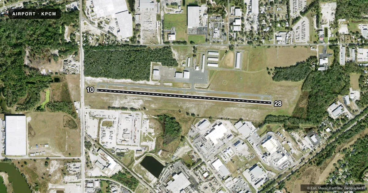
Runways & pattern
Full pagePattern entry · RWY 10
LEFT TRAFFICRunway end performance
| End | TORA | TODA | ASDA | LDA | VGSI | Approach lights | Obstruction |
|---|---|---|---|---|---|---|---|
| 10 | — | — | — | — | PAPI 2-box left(3°) | — | 15', road, 305' from thr, 250' R of cntrln, slope 7 |
| 28 | — | — | — | — | PAPI 2-box left(3°) | — | 43', trees, 1150' from thr, 275' R of cntrln, slope 22 |
Declared distances in feet. TORA = takeoff run available, TODA = takeoff distance, ASDA = accelerate-stop, LDA = landing distance.
Airport sketch
Runways drawn to scale from FAA survey coordinates, rendered over satellite imagery. Not for navigation.
Approaches & charts
Services on the field
Fuel grades, oxygen, maintenance, ramp storage and lighting — as declared to the FAA by the airport operator.
Fuel & services
- Fuel
- 100LLA
- Oxygen (bottled)
- Not available
- Oxygen (bulk)
- Not available
- Airframe repair
- Major
- Power plant repair
- Major
- Other services
- INSTR,RNTL,SALES
Ramp & ground
- Transient storage
- Tie-down
- Hangar
- Landing fee
- No fee published
- Customs
- Not available
- Lighting schedule
- SEE RMK
- Beacon schedule
- SS-SR
- Beacon
- White / Green (civil land)(WG)
- Wind indicator
- Lighted
- Segmented circle
- Yes
Fuel & FBOs
Cheapest 100LL and Jet A on the field and nearby. Always confirm with the FBO before taxi.
Airport notes
Surface conditions, obstructions, local procedures, lighting outages and other notes published with each FAA cycle.
General notes
- NMRS 1099 FT & 1549 FT MSL TWRS 12 NM SSW.
- GCO AVBL ON FREQ 121.725 TAMPA CLNC DEL, FOR PCM.
- FOR CD IF UNA VIA GCO CTC TAMPA APCH AT 813-878-2528.
- VFR ACFT ARR/DEP PLANT CITY ARPT, EXER CTN DUE TO SML AND HVY TBJT ACFT TRSNG ARPT TFC AREA 1700 FT AND ABV ON APCH TO LAKELAND INTL 6.5 NM EAST.
- 24 HR ADVN NOTICE OR IMT REPORTING UPON LDG FOR ACFT EQUIPPED WITH WEATHER MODIFICATION OR GEOENGINEERING EQUIP. 813-870-8770 EXT. 3
Lighting notes
- ACTVT REIL RWY 10 & 28; PAPI RWY 10 & 28; MIRL RWY 10/28 - CTAF.
Approach & departure obstructions
- 10NOISE ABATEMENT PROC IN EFCT FOR DEP; NO TURNS BLW 500 FT AGL UNLESS DIRECTED BY ATC.
- 10RWY 10 APCH RATIO 34:1 TO DTHR.
Other notes
- MANAGERAIRPORT PHYSICAL ADDRESS: 4007 AIRPORT RD, PLANT CITY, FL 33563
VFR map & nearby airports
VFR sectional. Tap any ICAO chip to open that airport.
Key facts · KPCM
Answer card- ICAO
- KPCM
- Name
- PLANT CITY
- Location
- PLANT CITY, FLORIDA
- Elevation
- 152.7 ft MSL
- Traffic pattern altitude
- 1,152.7 ft MSL (1,000 AGL)
- Control tower
- Non-towered (use CTAF)
- Total runways
- 1
- Longest runway
- 10/28 · 3,950 ft
- Published ILS approaches
- 0
- Published frequencies
- 5
- Magnetic variation
- 5°
- Current flight rules
- VFR
- Current wind
- 020° at 4 kt
- Favored runway now
- RWY 10
Plant City Airport sits in Plant City, Florida. The field elevation is 152.7 ft MSL. It has one runway. Runway 10/28 is 3,950 ft asphalt, which is the longest runway on the field. There is no control tower. CTAF and UNICOM are both 123.05. Tampa Approach handles the area on the published approach and departure frequencies.
No ILS approaches are published here. Runway 10 and Runway 28 both have active runway end identifier lights. PAPI is available on both ends. Medium intensity runway lights are controlled on CTAF.
Pattern altitude is not published. Use the standard 1,000 ft AGL pattern unless ATC or local guidance says otherwise. Atlas Aviation is on the field. It carries 100LL, Jet A and Jet A Prist. If you need current ramp details or service status, call them at (813) 752-4710.
Noise abatement is published for departures. Do not turn below 500 ft AGL unless ATC directs it. Pilots should also watch for traffic from Lakeland International 6.5 NM east. Small and heavy turboprops may be transiting the area at 1,700 ft and above. The runway 10 approach also has a published obstacle clearance note. Check the current Chart Supplement before you go.