METAR & TAF KZPH
Current METAR
Observed 13:35Z
KZPH 271335Z AUTO 35008KT 7SM BKN028 OVC050 26/25 A2997 RMK A02 P0001 T02590248
- Wind
- 350° @ 8 kt
- Visibility
- 7 SM
- Temp / Dew
- 26°C / 25°C
- Altimeter
- 29.97 inHg
- Clouds
- OVC
- Density alt
- 1,369 ft
- Ceiling
- 2,800 ft AGL
- Rules
- MVFR
Airport info & contacts
Manager on record, flight service, ARTCC, attendance schedule and pattern altitude — published by the FAA and refreshed every 28 days.
Location
- From city
- 1 NM SE
- VFR sectional
- JACKSONVILLE
- ARTCC
- ZMA · MIAMI
- NOTAM facility
- PIE (NOTAM-D)
Airport manager
- Name
- NATHAN COLEMAN
- Phone
- 813-780-0030
- Address
- ZEPHYRHILLS MUNICIPAL AIRPORT, 39450 SOUTH AVENUE, ZEPHYRHILLS FL 33542
Flight service · Hours
- FSS PIE
- SAINT PETERSBURG1-800-WX-BRIEF
- Attendance
- MON-SAT · 0800-1700
Frequencies
Tap any row to copy the frequency to your clipboard.
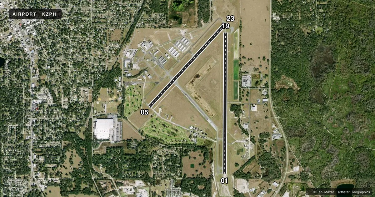
Runways & pattern
Full pagePattern entry · RWY 01
LEFT TRAFFIC| Runway | Heading (°M) | Length | Surface | Traffic |
|---|---|---|---|---|
| 01/19Favored | 354° / 174° | 6,201 ft | ASPH | 19 R |
| 05/23 | 37° / 217° | 5,001 ft | ASPH | 23 R |
Runway end performance
| End | TORA | TODA | ASDA | LDA | VGSI | Approach lights | Obstruction |
|---|---|---|---|---|---|---|---|
| 01 | — | — | — | — | PAPI 4-box left(3°) | — | 49', trees, 2385' from thr, 225' R of cntrln, slope 44 |
| 19 | — | — | — | — | PAPI 4-box left(3°) | — | 75', trees, 3365' from thr, 0' R of cntrln, slope 42 |
| 05 | — | — | — | — | PAPI 4-box left(3.63°) | — | 59', trees, 2230' from thr, 235' R of cntrln, slope 34 |
| 23 | — | — | — | — | PAPI 4-box left(3.61°) | — | 42', trees, 1470' from thr, 155' R of cntrln, slope 30 |
Declared distances in feet. TORA = takeoff run available, TODA = takeoff distance, ASDA = accelerate-stop, LDA = landing distance.
Airport sketch
Runways drawn to scale from FAA survey coordinates, rendered over satellite imagery. Not for navigation.
Approaches & charts
Services on the field
Fuel grades, oxygen, maintenance, ramp storage and lighting — as declared to the FAA by the airport operator.
Fuel & services
- Fuel
- 100LLAA+
- Oxygen (bottled)
- Not available
- Oxygen (bulk)
- Not available
- Airframe repair
- Major
- Power plant repair
- Major
- Other services
- GLD,INSTR,PAJA,RNTL,TOW
Ramp & ground
- Transient storage
- Tie-down
- Hangar
- Landing fee
- No fee published
- Customs
- Not available
- Lighting schedule
- SEE RMK
- Beacon schedule
- SS-SR
- Beacon
- White / Green (civil land)(WG)
- Wind indicator
- Lighted
Fuel & FBOs
Cheapest 100LL and Jet A on the field and nearby. Always confirm with the FBO before taxi.
Airport notes
Surface conditions, obstructions, local procedures, lighting outages and other notes published with each FAA cycle.
General notes
- 24 FT PLINE CROSSES APCH 800-1300 FT FROM RWY 23 END; MKD WITH RED FLAGS.
- GLIDER OPS 6000 FT & BLW SR-SS.
- SKY-DIVING ACFT DESCENDING FROM 13500 FT & ENTERING OPPOSITE TFC PAT FOR RWY 1/19 E OF ARPT.
- PAEW ADJ TO RWYS & TWYS.
- EXERCISE CAUTION; EXTENSIVE ACFT OPS ALL CATS & TYPES USING RWY 1/19; PARL TWY NOT AVBL.
- NOISE SENSITIVE AREA NE & WEST OF ARPT; MNTN PAT ALTS & AVOID PWR CHG OVR RESIDENTAL AREAS.
- FOR CD CTC TAMPA APCH AT 813-878-2528.
- PATTERN ALTITUDE TWIN ENGINE 1500 FT AGL.
- 24 HR ADVN NOTICE OR IMT REPORTING UPON LDG FOR ACFT EQUIPPED WITH WEATHER MODIFICATION OR GEOENGINEERING EQUIP CTC ARPT 813-456-7890.
Lighting notes
- ACTVT PAPI RWY 01, 05, 19 & 23; REIL RWY 1 & 19 - CTAF. HIRL RWY 1/19; MIRL RWY 5/23 PRESET TO LOW INTST DUSK-2200; INCR INTST & ACTVT AFT 2200 - CTAF.
Fuel notes
- 100LLFUEL AVBL H24 WITH CREDIT CARD; AFT HR FUEL SVC - 813-714-6797.
Other notes
- EXISTED PRIOR TO 1959.
VFR map & nearby airports
VFR sectional. Tap any ICAO chip to open that airport.
Key facts · KZPH
Answer card- ICAO
- KZPH
- Name
- ZEPHYRHILLS MUNI
- Location
- ZEPHYRHILLS, FLORIDA
- Elevation
- 89.9 ft MSL
- Traffic pattern altitude
- 1,089.9 ft MSL (1,000 AGL)
- Control tower
- Non-towered (use CTAF)
- Total runways
- 2
- Longest runway
- 01/19 · 6,201 ft
- Published ILS approaches
- 0
- Published frequencies
- 4
- Magnetic variation
- 6°
- Current flight rules
- MVFR
- Current wind
- 350° at 8 kt
- Favored runway now
- RWY 01
Zephyrhills Muni is in Zephyrhills, Florida. Field elevation is 89.9 ft MSL. The airport has two asphalt runways. Runway 01/19 is the longest at 6,201 ft. Runway 05/23 is 5,001 ft. No control tower is published, so use CTAF 123.075 for local traffic and UNICOM. Tampa Approach handles APCH and DEP on 119.9 and 290.3. No ILS approaches are published here.
Pattern altitude is not published for light piston aircraft, so use the standard 1,000 ft AGL unless local procedures say otherwise. The published twin-engine pattern altitude is 1,500 ft AGL. The field carries a lot of mixed traffic. That includes gliders and skydiving operations. Runway 01/19 sees extensive use. There is no parallel taxiway. A powerline crosses the approach to runway 23. It is marked with red flags. There is also powerline activity near the runways and taxiways.
On field, Zephyrhills Municipal Airport offers AVGAS 100LL and Jet A Prist. Fuel is available 24 hours with credit card. After hours fuel service is available by phone. Noise sensitive areas are northeast and west of the airport. Keep pattern work tight. Avoid power changes over residential areas. PAPI is active on all four runway ends. Runway lighting details vary by runway and time of day, so brief the current lighting setup before night operations.