METAR & TAF KTPF
Current METAR
Observed 21:35Z
KTPF 112135Z AUTO 22011KT 9SM TS SCT029 BKN037 OVC100 31/25 A3009 RMK AO2 TSB2132 T03110251 $
- Wind
- 220° @ 11 kt
- Visibility
- 9 SM
- Temp / Dew
- 31°C / 25°C
- Altimeter
- 30.09 inHg
- Clouds
- OVC
- Density alt
- 1,718 ft
- Ceiling
- 3,700 ft AGL
- Rules
- VFR
Airport info & contacts
Manager on record, flight service, ARTCC, attendance schedule and pattern altitude — published by the FAA and refreshed every 28 days.
Location
- From city
- 3 NM S
- VFR sectional
- MIAMI
- Pattern altitude
- 900 ft AGL · 907 ft MSL
- ARTCC
- ZMA · MIAMI
- NOTAM facility
- TPF (NOTAM-D)
Airport manager
- Name
- BRETT FAY
- Phone
- 813-870-8735
- Address
- PO BOX 22287, TAMPA FL 33606
Flight service · Hours
- FSS PIE
- SAINT PETERSBURG1-800-WX-BRIEF
- Attendance
- 0700-1900
Frequencies
Tap any row to copy the frequency to your clipboard.
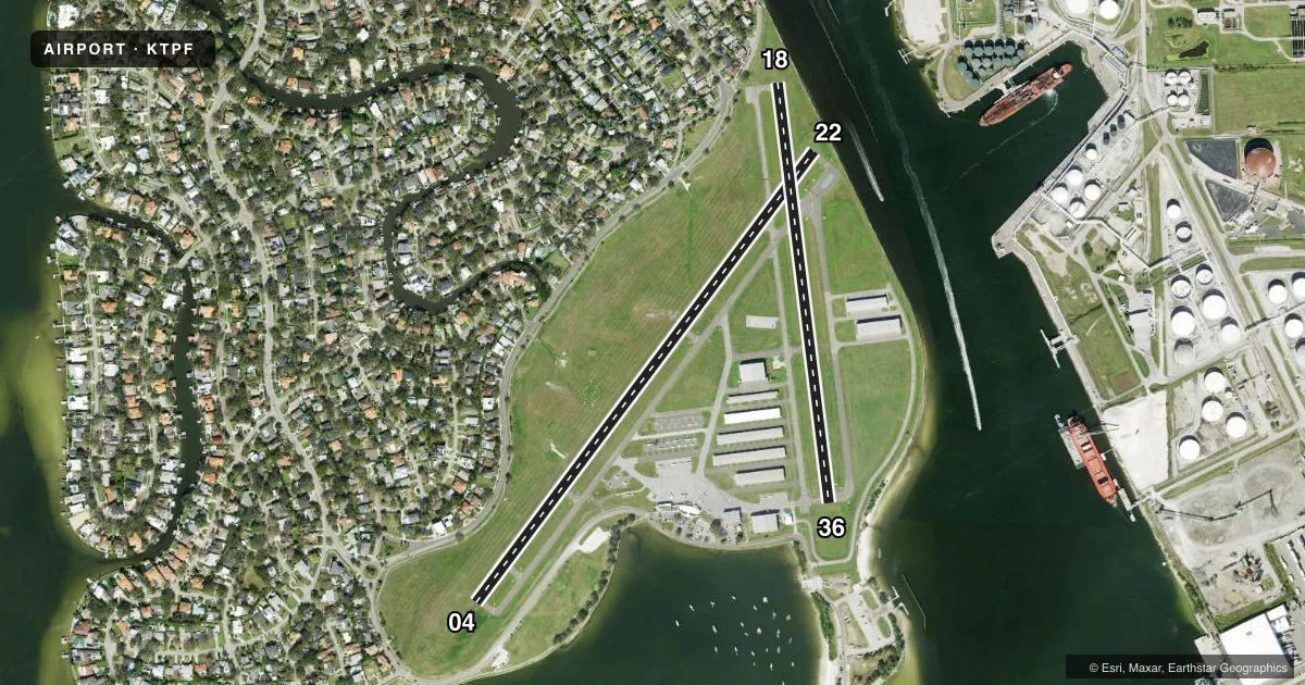
Runways & pattern
Full pagePattern entry · RWY 22
LEFT TRAFFIC| Runway | Heading (°M) | Length | Surface | Traffic |
|---|---|---|---|---|
| 04/22Favored | 32° / 212° | 3,583 ft | ASPH | 04 R |
| 18/36 | 168° / 348° | 2,687 ft | ASPH | 36 R |
Runway end performance
| End | TORA | TODA | ASDA | LDA | VGSI | Approach lights | Obstruction |
|---|---|---|---|---|---|---|---|
| 04 | 3,403' | 3,403' | 3,403' | 3,224' | PAPI 4-box left(3.5°) | — | 6', fence, 200' from thr, 222' R of cntrln, slope 1 |
| 22 | 3,404' | 3,404' | 3,404' | 3,403' | — | — | 30', boat, 415' from thr, 250' R of cntrln, slope 7 |
| 18 | 2,687' | 2,687' | 2,574' | 2,371' | — | — | 6', fence, 200' from thr, 93' R of cntrln, slope 1 |
| 36 | 2,487' | 2,487' | 2,512' | 2,311' | PAPI 2-box right(3°) | — | 5', fence, 200' from thr, 150' R of cntrln, slope 1 |
Declared distances in feet. TORA = takeoff run available, TODA = takeoff distance, ASDA = accelerate-stop, LDA = landing distance.
Airport sketch
Runways drawn to scale from FAA survey coordinates, rendered over satellite imagery. Not for navigation.
Approaches & charts
Services on the field
Fuel grades, oxygen, maintenance, ramp storage and lighting — as declared to the FAA by the airport operator.
Fuel & services
- Fuel
- 100LLA
- Oxygen (bottled)
- Low pressure
- Oxygen (bulk)
- HIGH/LOW
- Airframe repair
- Major
- Power plant repair
- Major
- Other services
- AVNCS,CHTR,INSTR,RNTL
Ramp & ground
- Transient storage
- Tie-down
- Hangar
- Landing fee
- No fee published
- Customs
- Not available
- Lighting schedule
- SEE RMK
- Beacon schedule
- SS-SR
- Beacon
- White / Green (civil land)(WG)
- Wind indicator
- Lighted
Fuel & FBOs
Cheapest 100LL and Jet A on the field and nearby. Always confirm with the FBO before taxi.
Airport notes
Surface conditions, obstructions, local procedures, lighting outages and other notes published with each FAA cycle.
General notes
- OCEAN VESSEL SHIP CHANNEL EAST.
- GULLS ON AND INVOF ARPT.
- TWY E CLSD TO ACFT WITH WING SPANS IN EXCESS OF 40 FT.
- BE ALERT: MACDILL AFB LCTD 0.6 MILES SW.
- FOR CD CTC TAMPA APCH AT 813-878-2528
- BE ALERT: GA TRAFFIC DEPARTING TPF SHOULD BE ADVISED MILITARY CLASS D AIRSPACE 0.6 MILES OFF THE DEPARTURE END OF RUNWAY 22. GA TRAFFIC MUST EXERCISE EXTREME CAUTION FOR OPPOSING MILITARY TRAFFIC IN THE PATTERN FOR RUNWAY 5-23 AT MACDILL AFB
- 24 HR ADVN NOTICE OR IMT REPORTING UPON LDG FOR ACFT EQUIPPED WITH WEATHER MODIFICATION OR GEOENGINEERING EQUIP. 813-870-8770 EXT. 3
Lighting notes
- ACTVT REIL RWY 22; PAPI RWY 04, 36; MIRL RWY 04/22 AND 18/36 - CTAF.
Approach & departure obstructions
- 046 FT FENCE 200 FT FM RWY END 222 FT R.
- 18RWY 18 HAS 6 FT FENCE AND 15 FT ROAD 200 FT FM RWY END 93 FT RIGHT.
- 36RWY 36 HAS 5 FT FENCE AND 15 FT ROAD 200 FT FM RWY END 150 FT L.
- 18SHIP CHANNEL RWY 18 APCH/DEP END.
- 22SHIP CHANNEL RWY 22 APCH/DEP END.
- 04RWY 04 APCH RATIO 26:1 TO THE DTHR.
- 18APCH RATIO 20:1 TO DTHR.
- 22RWY 22 APCH RATIO 26:1 TO THE DTHR.
- 36APCH RATIO 25:1 TO DTHR.
Other notes
- OWNERJOHN TILIACOS
- OWNER813-251-1752
VFR map & nearby airports
VFR sectional. Tap any ICAO chip to open that airport.
Key facts · KTPF
Answer card- ICAO
- KTPF
- Name
- PETER O KNIGHT
- Location
- TAMPA, FLORIDA
- Elevation
- 7.4 ft MSL
- Traffic pattern altitude
- 907.4 ft MSL (900 AGL)
- Control tower
- Non-towered (use CTAF)
- Total runways
- 2
- Longest runway
- 04/22 · 3,583 ft
- Published ILS approaches
- 0
- Published frequencies
- 5
- Magnetic variation
- 5°
- Current flight rules
- VFR
- Current wind
- 220° at 11 kt
- Favored runway now
- RWY 22
Peter O Knight is in Tampa, Florida. The field elevation is 7.4 ft MSL. It has two asphalt runways. The longest is runway 04/22 at 3,583 ft. There is no control tower. Use CTAF 122.725 for local traffic calls. No ILS approaches are published here.
Pattern altitude is 900 ft AGL. That is 907.4 ft MSL. Atlas Aviation is on the field. It carries 100LL, Jet A and Jet A Prist. If you need clearance delivery, contact Tampa Approach at 813-878-2528. The published remarks also call out gull activity on and near the airport.
This is a low-elevation coastal field with busy local traffic nearby. MacDill Air Force Base is 0.6 miles southwest. The remarks warn GA pilots to be alert for military Class D traffic near the departure end of runway 22. Runway 04 has a displaced threshold note with a 26 to 1 approach ratio. Runway 18 also has a displaced-threshold note. Runway 22 has runway end identifier lights. Runways 04 and 36 have PAPI. Medium intensity runway lights are on both runways. Check the current FAA Chart Supplement for any noise or operational changes before you go.