METAR & TAF 48X
48X does not publish a METAR.
Showing the nearest reporting station: KSPG (ALBERT WHITTED) · 9.3 NM away. Conditions at 48X may differ.
METAR · KSPG
Observed 17:10Z
KSPG 271710Z 34003KT 3SM TSRA BR FEW009 BKN060 OVC080 26/26 A2996 RMK AO2 LTG DSNT ALQDS TSE1656B09 P0005 T02610256
- Wind
- 340° @ 3 kt
- Visibility
- 3 SM
- Temp / Dew
- 26°C / 26°C
- Altimeter
- 29.96 inHg
- Clouds
- OVC
- Density alt
- 1,304 ft
- Ceiling
- 6,000 ft AGL
- Rules
- MVFR
Airport info & contacts
Manager on record, flight service, ARTCC, attendance schedule and pattern altitude — published by the FAA and refreshed every 28 days.
Location
- From city
- 7 NM NE
- VFR sectional
- MIAMI
- ARTCC
- ZMA · MIAMI
- NOTAM facility
- PIE (NOTAM-D)
Airport manager
- Name
- TOM REEDER
- Phone
- 941-722-9296
- Address
- 14108 U.S. HIGHWAY 41 NORTH, PALMETTO FL 34221
Flight service · Hours
- FSS PIE
- SAINT PETERSBURG1-800-WX-BRIEF
- Attendance
- MON-FRI · 0900-1700
- SAT · 0900-1200
Frequencies
Tap any row to copy the frequency to your clipboard.
Runways & pattern
Full pagePattern entry · RWY 25
LEFT TRAFFICRunway end performance
| End | TORA | TODA | ASDA | LDA | VGSI | Approach lights | Obstruction |
|---|---|---|---|---|---|---|---|
| 07 | — | — | — | — | — | — | 38', trees, 745' from thr, 125' R of cntrln, slope 20 |
Declared distances in feet. TORA = takeoff run available, TODA = takeoff distance, ASDA = accelerate-stop, LDA = landing distance.
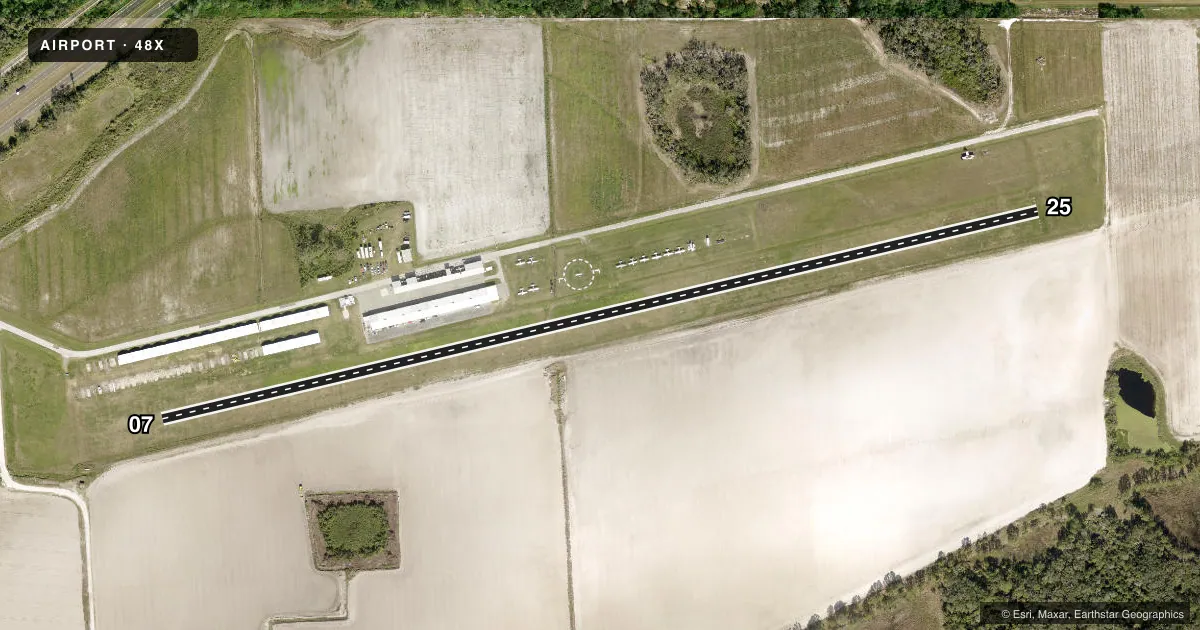
Airport sketch
Runways drawn to scale from FAA survey coordinates, rendered over satellite imagery. Not for navigation.
Approaches & charts
Services on the field
Fuel grades, oxygen, maintenance, ramp storage and lighting — as declared to the FAA by the airport operator.
Fuel & services
- Fuel
- 100LL
- Airframe repair
- Minor
- Power plant repair
- Minor
- Other services
- INSTR,RNTL
Ramp & ground
- Transient storage
- Tie-down
- Hangar
- Landing fee
- No fee published
- Lighting schedule
- SEE RMK
- Wind indicator
- Yes
- Segmented circle
- Yes
Fuel & FBOs
Cheapest 100LL and Jet A on the field and nearby. Always confirm with the FBO before taxi.
Airport notes
Surface conditions, obstructions, local procedures, lighting outages and other notes published with each FAA cycle.
General notes
- BIRDS, WILDLIFE AND DEER ON AND INVOF ARPT.
- RWY 07/25 FIRST 500 FT EAST END SOFT AFTER HEAVY SEASONAL RAINS.
- ARPT CLSD TO TURBINE HOPS INCLG HOVER AND PRACTICE MANUEVERS AT NE FIELD ADJ TO RWY 7/25 EXC BELL JET RANGERS, EMERG. CALL IN ADVN 941-722-9296.
- FOR CD CTC TAMPA APCH AT 813-878-2528
Lighting notes
- LIRL RWY 7/25 AVBL BY PHONE REQUEST 941-722-9296.
Fuel notes
- 100LLFUEL AVBL DAILY SR-SS.
Approach & departure obstructions
- 07RWY 07 & 25 THLDS MKD BY 3 GREEN LGTS AND 1 BUCKET ON EACH SIDE OF RWY.
- 25RWY 07 AND 25 EDGES MARKED BY PAILS ON EACH SIDE OF RWY.
- 07ACFT HNGRS 135 FT L OF CNTRLN FIRST HALF OF RWY 07. ACFT PARKED 135 FT R OF CNTRLN FIRST 1/3 OF RWY 25.
Other notes
- PRVDD VFR; ALL TFC PATTERNS ARE ESTABLISHED ON SOUTH SIDE OF RY & RY CENTERLINE EXTENDED; ARPT OPERATOR ESTABLISHES/MAINTAINS SEGMENTED CIRCLE; WINDSOCK MAINTAINED; AND ARPT MEETS REQUIREMENTS OF STATE FOR PUBLIC USE.
- 3CALL AMGR FOR AFTER HRS SVC AND CHECK RY CONDITIONS 941-722-9296.
- MANAGERAIRPORT PHYSICAL ADDRESS: 14108 U.S. HIGHWAY 41 NORTH; FAX: 941-721-9067
- OWNERCONTACT PERSON: TOM REEDER: 941-527-9714
VFR map & nearby airports
VFR sectional. Tap any ICAO chip to open that airport.
Key facts · 48X
Answer card- ICAO
- 48X
- Name
- MANATEE
- Location
- PALMETTO, FLORIDA
- Elevation
- 27 ft MSL
- Traffic pattern altitude
- 1,027 ft MSL (1,000 AGL)
- Control tower
- Non-towered (use CTAF)
- Total runways
- 1
- Longest runway
- 07/25 · 3,120 ft
- Published ILS approaches
- 0
- Published frequencies
- 1
- Magnetic variation
- 2°
- Current flight rules
- MVFR
- Current wind
- 340° at 3 kt
- Favored runway now
- RWY 25
Manatee Airport (48X) sits in Palmetto, Florida. Field elevation is 27 ft MSL. It has one runway, 07/25, which is 3,120 ft of turf. The airport is non-towered. CTAF is 122.9. No ILS approaches are published here.
Pattern altitude is not published. Use 1,000 ft AGL for light piston operations unless local guidance says otherwise. Traffic patterns are on the south side of the runway and runway centerline extended. The airport operator maintains a segmented circle and a windsock. The field also has a few operational items to watch. The first 500 ft at the east end of runway 07/25 can be soft after heavy seasonal rains. Birds, wildlife and deer are reported on and near the airport. Hangars sit 135 ft left of centerline on the first half of runway 07. Parked aircraft are 135 ft right of centerline on the first one-third of runway 25.
Manatee Airport carries 100LL through the on-field Manatee Airport FBO. Fuel is available daily from sunrise to sunset. Call ahead at 941-722-9296 for after-hours service or runway condition checks. The airport is closed to turbine helicopter operations for hover and practice maneuvers at the northeast field adjacent to runway 07/25, except Bell Jet Rangers and emergencies. For clearance delivery, contact Tampa Approach. Pilots should plan for turf performance. They should also plan for soft spots after rain. Normal Florida density altitude planning applies on warm days.