METAR & TAF KSRQ
Current METAR
Observed 14:53Z
KSRQ 271453Z 29010KT 10SM FEW028 31/24 A2995
- Wind
- 290° @ 10 kt
- Visibility
- 10 SM
- Temp / Dew
- 31°C / 24°C
- Altimeter
- 29.95 inHg
- Clouds
- FEW
- Density alt
- 1,920 ft
- Ceiling
- Unlimited
- Rules
- VFR
Airport info & contacts
Manager on record, flight service, ARTCC, attendance schedule and pattern altitude — published by the FAA and refreshed every 28 days.
Location
- From city
- 3 NM N
- VFR sectional
- MIAMI
- ARTCC
- ZMA · MIAMI
- NOTAM facility
- SRQ (NOTAM-D)
Airport manager
- Name
- PAUL HOBACK, JR.
- Phone
- 941-359-5200
- Address
- 6000 AIRPORT CIRCLE, SARASOTA FL 34243-2105
Flight service · Hours
- FSS PIE
- SAINT PETERSBURG1-800-WX-BRIEF
- Attendance
- ALL
Frequencies
Tap any row to copy the frequency to your clipboard.
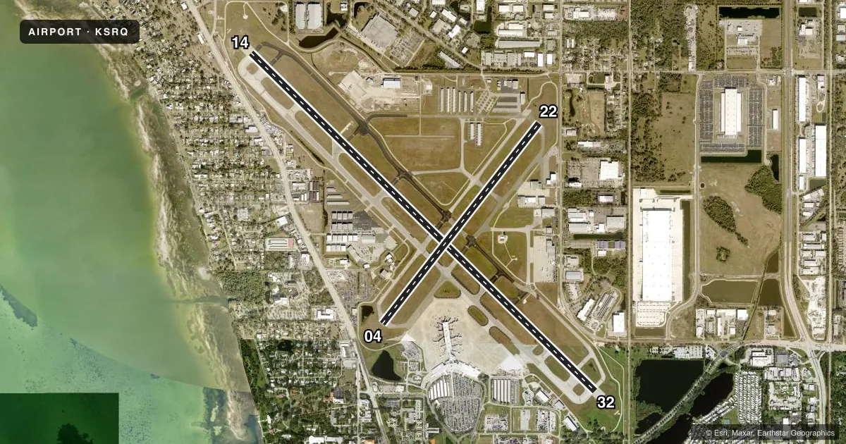
Runways & pattern
Full pagePattern entry · RWY 32
LEFT TRAFFIC| Runway | Heading (°M) | Length | Surface | Traffic |
|---|---|---|---|---|
| 14/32Favored | 129° / 309° | 9,500 ft | ASPH | Standard L |
| 04/22 | 33° / 213° | 5,006 ft | ASPH | Standard L |
Runway end performance
| End | TORA | TODA | ASDA | LDA | VGSI | Approach lights | Obstruction |
|---|---|---|---|---|---|---|---|
| 14 | 8,350' | 9,500' | 8,890' | 7,540' | PAPI 4-box left(3°) | MALSR | 20', berm, 200' from thr, 465' R of cntrln, slope 0 |
| 32 | 8,150' | 9,500' | 8,660' | 7,510' | PAPI 4-box left(3°) | MALSR | — |
| 04 | 5,006' | 5,006' | 5,006' | 5,006' | PAPI 4-box left(3°) | — | — |
| 22 | 5,006' | 5,006' | 5,006' | 5,006' | PAPI 4-box left(3°) | — | 15', road, 335' from thr, 270' R of cntrln, slope 9 |
Declared distances in feet. TORA = takeoff run available, TODA = takeoff distance, ASDA = accelerate-stop, LDA = landing distance.
Airport sketch
Runways drawn to scale from FAA survey coordinates, rendered over satellite imagery. Not for navigation.
Approaches & charts
ILS · 2
Services on the field
Fuel grades, oxygen, maintenance, ramp storage and lighting — as declared to the FAA by the airport operator.
Fuel & services
- Fuel
- 100LLA
- Oxygen (bottled)
- HIGH/LOW
- Oxygen (bulk)
- HIGH/LOW
- Airframe repair
- Major
- Power plant repair
- Major
- Other services
- AVNCS,CHTR,INSTR,RNTL,SALES
Ramp & ground
- Transient storage
- Tie-down
- Hangar
- Landing fee
- No fee published
- Customs
- Not available
- Lighting schedule
- SEE RMK
- Beacon schedule
- SS-SR
- Beacon
- White / Green (civil land)(WG)
- Wind indicator
- Lighted
- Segmented circle
- No
Fuel & FBOs
Cheapest 100LL and Jet A on the field and nearby. Always confirm with the FBO before taxi.
Airport notes
Surface conditions, obstructions, local procedures, lighting outages and other notes published with each FAA cycle.
General notes
- SAID IN USE. OPER TRANSPONDERS WITH ALT REPORTING MODE AND ADS-B (IF EQUIPPED) ENABLED ON ALL ARPT SFC.
- TWY F LTD TO 70000 LBS GWT.
- STRICT NOISE ABATEMENT PROC IN EFCT FOR DEP JET ACFT.
- BIRDS ON & INVOF ARPT.
- MISC: CLASS C ASP EFF 700-0100 ++; OT CLASS G. CLASS E 700 FT AGL & ABV.
- TRML RAMP IS UNCTLD. DO NOT CALL FOR PUSH/POWER BACK. ADZ GC WHEN READY TO TAXI.
- WHEN TWR CLSD HOLD AT ILS HOLD PSN SIGNS ABEAM RWY 14 & RWY 32 THR DURG ALL WX CONDS. APCH TO RWY 14 & RWY 32 CSDRD CLEAR WHEN ACFT ARE BYD RWY 14 & RWY 32 THR BASE UPON LDG DRCTN.
- DIVD ACR ACFT ADZD TO USE TRML RAMP.
- PPR FOR HIGH SPEED TAXI TEST - ARPT OPS 941-359-2770 EXT 4300.
- FLD CONDS UNMON 0100-0530.
- NO INTL FLT DVRSNS ACPTD UNLESS EMERG.
- FOR CD IF UNA TO CTC ON FSS FREQ, CTC TAMPA APCH AT 813-878-2528.
- ACFT RUN-UPS PROHIBITED AT TRML GATES.
- US CUST GA ACFT AT W END OF TRML RAMP.
- TRML GATE B1 UNAVBL TO ACFT WINGSPAN MORE THAN 118 FT.
- 24 HR ADVN NOTICE OR IMT REPORTING UPON LDG FOR ACFT EQUIPPED WITH WEATHER MODIFICATION OR GEOENGINEERING EQUIP CTC ARPT OPS 941-359-2770 X4300.
- TWY R5 CLSD TO ACFT WINGSPAN MORE THAN 118 FT.
Lighting notes
- WHEN ATCT CLSD ACTVT MALSR RWY 14 & 32; REIL RWY 22; PAPI RWY 04, 22, 14 & 32; HIRL RWY 04/22 & 14/32 - CTAF.
Fuel notes
- 100LLFOR FUEL AVBL CTC FBO. ACR FUEL SVC UNAVBL AFT LAST SKED DEP. 24 HR 100LL SELF SVC FUEL AVBL AT NORTH FBO.
Runway surface & condition
- 04/22PCR VALUE: 580/F/A/X/T
- 14/32PCR VALUE: 370/F/A/X/T
Approach & departure obstructions
- 14BERM 20 FT TALL 200 FT BFR AER RWY 14 465 RIGHT OF CNTRLN.
- 14RWY 14 APCH SLP 50:1 TO DTHR.
Other notes
- AND MANATEE CO.
- PPR US CUSTOMS USER FEE ARPT; SVC MON-FRI 0830-1630 - 813-634-1369. FEE PAYABLE ON SITE.
VFR map & nearby airports
VFR sectional. Tap any ICAO chip to open that airport.
Key facts · KSRQ
Answer card- ICAO
- KSRQ
- Name
- SARASOTA/BRADENTON INTL
- Location
- SARASOTA/BRADENTON, FLORIDA
- Elevation
- 29.9 ft MSL
- Traffic pattern altitude
- 1,029.9 ft MSL (1,000 AGL)
- Control tower
- Towered · 0600-0000
- Total runways
- 2
- Longest runway
- 14/32 · 9,500 ft
- Published ILS approaches
- 2
- Published frequencies
- 14
- Magnetic variation
- 5°
- Current flight rules
- VFR
- Current wind
- 290° at 10 kt
- Favored runway now
- RWY 32
Sarasota/Bradenton Intl sits in Sarasota and Bradenton, Florida. Field elevation is 29.9 ft MSL. The airport has two asphalt runways. The longest is 14/32 at 9,500 ft. Runway 04/22 is 5,006 ft. The tower is open 0600 to 0000. When the tower is closed, use CTAF 120.1. Follow the published lighting setup for the field.
ILS approaches are available to runway 14 and runway 32. Pattern altitude is not published in the facts, so use standard light piston pattern altitude of 1,000 ft AGL unless ATC gives different instructions. That puts you near 1,030 ft MSL at this field. Airspace is Class C from 700 to 0100. Outside those hours the field is Class G. Class E starts at 700 ft AGL and above. That matters here because the airport sits in a busy coastal metro area with a lot of mixed traffic.
On the field, Atlantic Aviation, Ascension FBO and Sheltair all carry 100LL, Jet A and Jet A Prist. Runway 14 has a berm 20 ft tall 200 ft before the threshold. It sits 465 ft right of centerline. Taxiway R5 and terminal gate B1 are restricted to aircraft with wingspans of 118 ft or less. Diverted aircraft should use the terminal ramp. Check the current FAA Chart Supplement for any noise or curfew restrictions before flying into the field.