METAR & TAF X36
X36 does not publish a METAR.
Showing the nearest reporting station: KVNC (VENICE MUNI) · 6.0 NM away. Conditions at X36 may differ.
METAR · KVNC
Observed 22:35Z
KVNC 262235Z AUTO 30010KT 10SM FEW250 31/26 A2995 RMK AO2 LTG DSNT NE AND E T03080259 $
- Wind
- 300° @ 10 kt
- Visibility
- 10 SM
- Temp / Dew
- 31°C / 26°C
- Altimeter
- 29.95 inHg
- Clouds
- FEW
- Density alt
- 1,901 ft
- Ceiling
- Unlimited
- Rules
- VFR
Airport info & contacts
Manager on record, flight service, ARTCC, attendance schedule and pattern altitude — published by the FAA and refreshed every 28 days.
Location
- From city
- 2 NM NW
- VFR sectional
- MIAMI
- ARTCC
- ZMA · MIAMI
- NOTAM facility
- PIE (NOTAM-D)
Airport manager
- Name
- RONNIE LOCKE
- Phone
- 941-233-0543
- Address
- 1001 SARASOTA CENTER BLVD, SARASOTA FL 34240-7840
Flight service · Hours
- FSS PIE
- SAINT PETERSBURG1-800-WX-BRIEF
- Attendance
- Unattended
Frequencies
Tap any row to copy the frequency to your clipboard.
Runways & pattern
Full pagePattern entry · RWY 30
LEFT TRAFFICRunway end performance
| End | TORA | TODA | ASDA | LDA | VGSI | Approach lights | Obstruction |
|---|---|---|---|---|---|---|---|
| 12 | — | — | — | — | — | — | 12', trees, 335' from thr, 40' R of cntrln, slope 27 |
| 30 | — | — | — | — | — | — | 4', fence, 0' from thr, 107' R of cntrln, slope 0 |
Declared distances in feet. TORA = takeoff run available, TODA = takeoff distance, ASDA = accelerate-stop, LDA = landing distance.
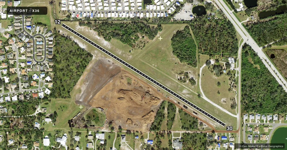
Airport sketch
Runways drawn to scale from FAA survey coordinates, rendered over satellite imagery. Not for navigation.
Approaches & charts
Services on the field
Fuel grades, oxygen, maintenance, ramp storage and lighting — as declared to the FAA by the airport operator.
Fuel & services
- Fuel
- Not available
- Oxygen (bottled)
- Not available
- Oxygen (bulk)
- Not available
Ramp & ground
- Transient storage
- Tie-down
- Landing fee
- No fee published
- Customs
- Not available
- Wind indicator
- Yes
- Segmented circle
- Yes
Fuel & FBOs
Cheapest 100LL and Jet A on the field and nearby. Always confirm with the FBO before taxi.
Airport notes
Surface conditions, obstructions, local procedures, lighting outages and other notes published with each FAA cycle.
General notes
- DRAINAGE SWALES ALONG SIDE BOTH RWYS.
- RY 12/30 ROUGH & BARE IN SPOTS.
- RY 12/30 30 FT TREES 140 FT BOTH SIDES OF CNTRLN.
- ULTRALIGHT ACTIVITY ON & INVOF ARPT.
- FOR CD CTC FORT MYERS APCH AT 239-416-1026, WHEN APCH CLSD CTC MIAMI ARTCC AT 305-716-1731.
Approach & departure obstructions
- 12RY 12/30 THLDS MARKED WITH 3 WHITE TIRES PERPENDICULAR TO CNTRLN.
- 30RY 12/30 EDGE MARKED WITH WHITE TIRES.
- 30RWY 30 20:1 TO DTHR.
Other notes
- EXISTED PRIOR TO 1959.
- MANAGERAIRPORT PHYSICAL ADDRESS: 1390 OLD ENGLEWOOD ROAD FAX: 941-650-3306.
- OWNERCONTACT PERSON: JONATHAN LEWIS 941-861-5000.
VFR map & nearby airports
VFR sectional. Tap any ICAO chip to open that airport.
Key facts · X36
Answer card- ICAO
- X36
- Name
- BUCHAN
- Location
- ENGLEWOOD, FLORIDA
- Elevation
- 15 ft MSL
- Traffic pattern altitude
- 1,015 ft MSL (1,000 AGL)
- Control tower
- Non-towered (use CTAF)
- Total runways
- 1
- Longest runway
- 12/30 · 2,040 ft
- Published ILS approaches
- 0
- Published frequencies
- 1
- Magnetic variation
- 2°
- Current flight rules
- VFR
- Current wind
- 300° at 10 kt
- Favored runway now
- RWY 30
Buchan is in Englewood, Florida. The field elevation is 15 ft MSL. It has one runway, 12/30, which is 2,040 ft long and surfaced with turf. There is no control tower. CTAF is 122.9. No ILS approaches are published here.
Pattern altitude is not published. For light piston operations, use the standard 1,000 ft AGL unless the current Chart Supplement or local procedure says otherwise. The runway markings are simple. Runway 12/30 edge markings use white tires. The thresholds are marked with three white tires perpendicular to the centerline. The runway is described as rough and bare in spots. Drainage swales run along both sides. There are also 30 ft trees about 140 ft from the centerline on both sides, so plan your approach and departure with that in mind.
No on-field FBOs are listed. Contact the airport operator directly before arrival if you need current services. Published remarks also note ultralight activity on and near the airport. For clearance delivery, contact Fort Myers Approach at 239-416-1026. When Approach is closed, contact Miami ARTCC at 305-716-1731. If you are planning a first visit, check the current Chart Supplement for any noise or operational notes before you go.