METAR & TAF KCOI
Current METAR
Observed 13:35Z
KCOI 271335Z AUTO VRB06G12KT 10SM SCT017 30/28 A2991 RMK AO2
- Wind
- VAR @ 6G12 kt
- Visibility
- 10 SM
- Temp / Dew
- 30°C / 28°C
- Altimeter
- 29.91 inHg
- Clouds
- SCT
- Density alt
- 1,820 ft
- Ceiling
- Unlimited
- Rules
- VFR
Airport info & contacts
Manager on record, flight service, ARTCC, attendance schedule and pattern altitude — published by the FAA and refreshed every 28 days.
Location
- From city
- 0 NM S
- VFR sectional
- JACKSONVILLE
- ARTCC
- ZJX · JACKSONVILLE
- NOTAM facility
- PIE (NOTAM-D)
Airport manager
- Name
- KEVIN DAUGHERTY
- Phone
- 321-267-8780
- Address
- 355 GOLDEN KNIGHTS BLVD, TITUSVILLE FL 32780
Flight service · Hours
- FSS PIE
- SAINT PETERSBURG1-800-WX-BRIEF
- Attendance
- 0800-1800
Frequencies
Tap any row to copy the frequency to your clipboard.
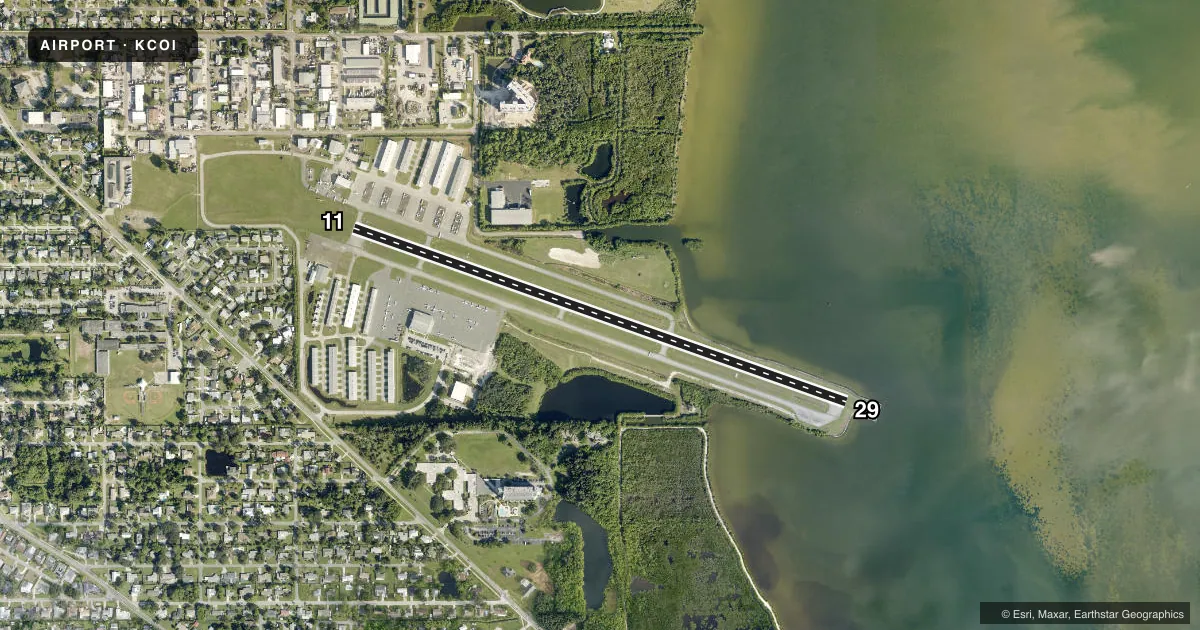
Runways & pattern
Full pagePattern entry · RWY 29
LEFT TRAFFICRunway end performance
| End | TORA | TODA | ASDA | LDA | VGSI | Approach lights | Obstruction |
|---|---|---|---|---|---|---|---|
| 11 | — | — | — | — | PAPI 2-box left(3°) | — | 20', bldg, 122' from thr, 250' R of cntrln, slope 1 |
| 29 | — | — | — | — | PAPI 2-box left(3°) | — | 25', boat, 700' from thr, 250' R of cntrln, slope 20 |
Declared distances in feet. TORA = takeoff run available, TODA = takeoff distance, ASDA = accelerate-stop, LDA = landing distance.
Airport sketch
Runways drawn to scale from FAA survey coordinates, rendered over satellite imagery. Not for navigation.
Approaches & charts
Services on the field
Fuel grades, oxygen, maintenance, ramp storage and lighting — as declared to the FAA by the airport operator.
Fuel & services
- Fuel
- 100LLA
- Oxygen (bottled)
- Not available
- Oxygen (bulk)
- Not available
- Airframe repair
- Major
- Power plant repair
- Major
- Other services
- AVNCS,INSTR,RNTL
Ramp & ground
- Transient storage
- Tie-down
- Landing fee
- No fee published
- Customs
- Not available
- Lighting schedule
- SEE RMK
- Beacon schedule
- SEE RMK
- Beacon
- White / Green (civil land)(WG)
- Wind indicator
- Lighted
Fuel & FBOs
Cheapest 100LL and Jet A on the field and nearby. Always confirm with the FBO before taxi.
Airport notes
Surface conditions, obstructions, local procedures, lighting outages and other notes published with each FAA cycle.
General notes
- BANNER TOWING.
- 24 HR HELI OPS SW RAMP.
- PATRICK AFB (KCOF) CLASS D AIRSPACE IN CLOSE PROXIMITY; KCOF CROSSING RWY 11/29 HAS SAME ORIENTATION AS MERRITT ISLAND ARPT.
- FOR CD OR TO CNL IFR CTC ORLANDO APCH AT 407-852-7500.
- NOISE SENSITIVE ARPT. VOLUNTARY NOISE ABATEMENT PROC IN EFCT. CLIMB OUT AT BEST ANGLE (VX), TURN CROSSWIND AT 700 FT (MID-RIVER, IF POSS) & MERGE WITH DOWNWIND TFC AT 1000 FT PAT ALT. NO TOUCH-AND-GO OPS BTN 8 PM AND 8 AM. NO REPETITIVE FLT OPS AT THE ARPT BTN 8 PM AND 7 AM. NO REPETITIVE FLT T OPS ON SUN AND NTL HOLS. IN LIEU OF TOUCH-AND-GO OPS PERFORM FULL STOP, TAXI-BACK OPS. AVOID FLYING AT LOW ALTS OVR NOISE SENSITIVE AREAS (NEWFOUND HARBOR DR).
Lighting notes
- ACTVT ROTG BCN - CTAF.
- ACTVT MIRL RWY 11/29 - CTAF.
Approach & departure obstructions
- 11UNLGT OBS IN APCH; 20 FT BLDG 122 FT FM RWY 250 FT L.
- 11RWY 11 MARKINGS FADED W/ NO BLACK OUTLINE.
- 29RWY 29 MARKINGS FADED W/ NO BLACK OUTLINE.
- 11APCH SLOPE 20:1 TO THE DSPLCD THLD.
Other notes
- VFR OPS ONLY.
- OWNERCTC PERSON: KEVIN DAUGHERTY, AAE
- MANAGER321-453-2222.
VFR map & nearby airports
VFR sectional. Tap any ICAO chip to open that airport.
Key facts · KCOI
Answer card- ICAO
- KCOI
- Name
- MERRITT ISLAND
- Location
- MERRITT ISLAND, FLORIDA
- Elevation
- 5.9 ft MSL
- Traffic pattern altitude
- 1,005.9 ft MSL (1,000 AGL)
- Control tower
- Non-towered (use CTAF)
- Total runways
- 1
- Longest runway
- 11/29 · 3,601 ft
- Published ILS approaches
- 0
- Published frequencies
- 4
- Magnetic variation
- 5°
- Current flight rules
- VFR
- Current wind
- 000° at 6 kt
- Favored runway now
- RWY 29
Merritt Island Airport sits on Merritt Island in Florida. Field elevation is 5.9 ft MSL. The airport has one runway, 11/29, which is 3,601 ft long. It is a non-towered field. Pattern altitude is not published, so use 1,000 ft AGL for light piston traffic unless the current Chart Supplement says otherwise. No ILS approaches are published.
Space Coast Aviation is on the field. It carries 100LL and Jet A. For IFR coordination, Orlando Approach handles clearance delivery and IFR cancel. The airport is VFR only. Medium intensity runway lights on 11/29 are activated on CTAF. The rotating beacon is also activated on CTAF.
This is a noise-sensitive airport. Voluntary noise abatement is in effect. The published departure flow calls for best angle climb, then a crosswind turn at 700 ft, then joining downwind at 1,000 ft pattern altitude if terrain and traffic allow. Avoid low flight over noise-sensitive areas such as Newfound Harbor Drive. Touch-and-goes are not allowed between 8 p.m. and 8 a.m. Repetitive training is also restricted overnight and on Sundays and national holidays. Patrick Air Force Base Class D is close by. Check the current sectional and the current Chart Supplement before arrival. There is also an unlighted 20 ft obstruction near the approach to runway 11.