METAR & TAF KMCO
Current METAR
Observed 09:53Z
KMCO 270953Z 22007KT 10SM FEW040 FEW100 26/24 A2991 RMK OCNL LTGIC DSNT W CB DSNT W
- Wind
- 220° @ 7 kt
- Visibility
- 10 SM
- Temp / Dew
- 26°C / 24°C
- Altimeter
- 29.91 inHg
- Clouds
- FEW
- Density alt
- 1,452 ft
- Ceiling
- Unlimited
- Rules
- VFR
Airport info & contacts
Manager on record, flight service, ARTCC, attendance schedule and pattern altitude — published by the FAA and refreshed every 28 days.
Location
- From city
- 6 NM SE
- VFR sectional
- JACKSONVILLE
- ARTCC
- ZJX · JACKSONVILLE
- NOTAM facility
- MCO (NOTAM-D)
Airport manager
- Name
- LANCE LYTTLE
- Phone
- 407-825-2020
- Address
- 1 JEFF FUQUA BLVD, ORLANDO FL 32827-4399
Flight service · Hours
- FSS PIE
- SAINT PETERSBURG1-800-WX-BRIEF
- Attendance
- ALL
Frequencies
Tap any row to copy the frequency to your clipboard.
Runways & pattern
Full pagePattern entry · RWY 18L
LEFT TRAFFIC| Runway | Heading (°M) | Length | Surface | Traffic |
|---|---|---|---|---|
| 18L/36RFavored | 173° / 353° | 12,005 ft | ASPH-CONC | Standard L |
| 18R/36L | 173° / 353° | 12,004 ft | ASPH-CONC | Standard L |
| 17R/35L | 173° / 353° | 10,000 ft | CONC | Standard L |
| 17L/35R | 173° / 353° | 9,001 ft | CONC | Standard L |
Runway end performance
| End | TORA | TODA | ASDA | LDA | VGSI | Approach lights | Obstruction |
|---|---|---|---|---|---|---|---|
| 18L | 12,005' | 12,005' | 12,005' | 12,005' | PAPI 4-box left(3°) | — | — |
| 36R | 12,005' | 12,005' | 11,601' | 11,601' | PAPI 4-box left(3°) | ALSF2 | — |
| 18R | 12,004' | 12,004' | 12,004' | 12,004' | PAPI 4-box left(3°) | MALSR | — |
| 36L | 12,004' | 12,004' | 11,621' | 11,621' | PAPI 4-box left(3°) | — | — |
| 17R | 10,000' | 10,000' | 10,000' | 10,000' | PAPI 4-box left(3°) | ALSF2 | — |
| 35L | 10,000' | 10,000' | 10,000' | 10,000' | PAPI 4-box right(3°) | ALSF2 | — |
| 17L | 9,001' | 9,001' | 9,001' | 9,001' | PAPI 4-box left(3°) | ALSF2 | — |
| 35R | 9,001' | 9,001' | 9,001' | 9,001' | PAPI 4-box right(3°) | ALSF2 | — |
Declared distances in feet. TORA = takeoff run available, TODA = takeoff distance, ASDA = accelerate-stop, LDA = landing distance.
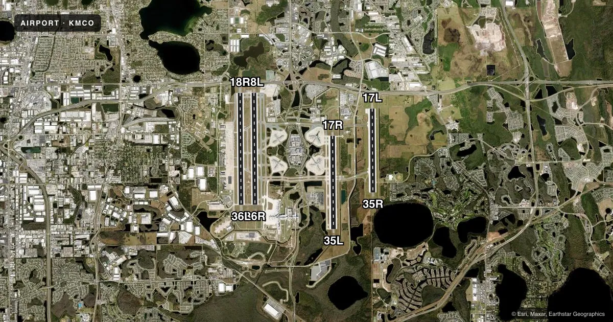
Airport sketch
Runways drawn to scale from FAA survey coordinates, rendered over satellite imagery. Not for navigation.
Approaches & charts
ILS · 7
Services on the field
Fuel grades, oxygen, maintenance, ramp storage and lighting — as declared to the FAA by the airport operator.
Fuel & services
- Fuel
- 100LLA
- Oxygen (bottled)
- Not available
- Oxygen (bulk)
- Not available
- Airframe repair
- Minor
- Power plant repair
- Minor
- Other services
- AFRT,CARGO
Ramp & ground
- Transient storage
- Tie-down
- Hangar
- Landing fee
- No fee published
- Customs
- Not available
- Lighting schedule
- SS-SR
- Beacon schedule
- SS-SR
- Beacon
- White / Green (civil land)(WG)
- Wind indicator
- Lighted
- Segmented circle
- No
Fuel & FBOs
Cheapest 100LL and Jet A on the field and nearby. Always confirm with the FBO before taxi.
Airport notes
Surface conditions, obstructions, local procedures, lighting outages and other notes published with each FAA cycle.
General notes
- BIRDS ON & INVOF ARPT.
- ALL AIRCRAFT DETERMINED TO BE FAA DESIGN GROUP IV AND ABOVE MUST PERFORM JUDGEMENTAL OVERSTEERING INSTEAD OF COCKPIT CNTRLN STEERING WHEN TAXIING.
- WHEN ORL ILS RY 7 AND MCO ILS RYS 17 & 18R SIMULTANEOUS OPERATIONS ARE CONDUCTED, ATC RADAR REQUIRED.
- BRIGHT LGTS ON ROAD BTN RY 17R/35L AND RY 17L/35R MAY BE MISTAKEN FOR RY LGTS.
- USE CAUTION IN VCNTY OF TWY "A" ALONG WEST RAMP.
- UNLESS ADV BY ATIS, DEP FLTS ON INITIAL CTC WITH GND CTL: ACFT ON WEST RAMP, AIRSIDE 1 & 3 (GATES 1-59) USE GND CTL 121.8. ACFT AT AIRSIDE 2 & 4 (GATES 60 AND HIGHER), USE GND CTL 126.4.
- TWY J3 AND TWY J4 RSTD TO WINGSPAN OF LESS THAN 118 FT.
- RUNWAY STATUS LIGHTS ARE IN OPERATION.
- ACFT WITH WINGSPAN GREATER THAN 214 FT MUST ADHERE TO SPECIFIC RY AND TAXI ROUTES. CONTACT AIRFIELD OPS AT 407-825-2036 FOR DETAILS.
- TWY A, SOUTH OF TWY A3 RSTD TO WINGSPAN OF LESS THAN 118 FT. PPR REQUIRED FOR WINGSPAN 118 FT OR GREATER.
- 24 HR PPR FOR ACFT EQUIPPED WITH WEATHER MODIFICATION OR GEOENGINEERING EQPT 407-825-2036.
- 24 HR PPR FOR ACFT EQUIPPED WITH WEATHER MODIFICATION OR GEOENGINEERING EQPT 407-825-2036.
Runway surface & condition
- 17L/35RPCR VALUE: 1090/R/B/W/T
- 17R/35LPCR VALUE: 1139/R/B/W/T
- 18L/36RPCR VALUE: 1028/R/B/W/T
- 18R/36LPCR VALUE: 1139/R/B/W/T
Other notes
- 18L/36RCENTER 75 FOOT KEEL SECTION OF RY CONCRETE FULL LENGTH; CENTER 100 FOOT KEEL SECTION OF RY CONCRETE FIRST 1000 FT, BOTH ENDS. REST OF RY WIDTH IS ASPHALT.
- 18R/36LCENTER 87 FOOT KEEL SECTION OF RY CONCRETE FULL LENGTH; REST OF RY WIDTH IS ASPHALT. LAST 3000 FT OF RY 18R IS CONCRETE FULL WIDTH.
VFR map & nearby airports
VFR sectional. Tap any ICAO chip to open that airport.
Key facts · KMCO
Answer card- ICAO
- KMCO
- Name
- ORLANDO INTL
- Location
- ORLANDO, FLORIDA
- Elevation
- 96.4 ft MSL
- Traffic pattern altitude
- 1,096.4 ft MSL (1,000 AGL)
- Control tower
- Towered · 24
- Total runways
- 4
- Longest runway
- 18L/36R · 12,005 ft
- Published ILS approaches
- 7
- Published frequencies
- 35
- Magnetic variation
- 6°
- Current flight rules
- VFR
- Current wind
- 220° at 7 kt
- Favored runway now
- RWY 18L
Orlando Intl sits in Orlando, Florida. Field elevation is 96.4 ft MSL. The airport has 4 runways. The longest is 12,005 ft. The tower is open 24 hours. Seven ILS approaches are published here, with coverage to runway ends 17L, 17R, 18R, 35L, 35R, 36L and 36R.
For light piston traffic, use a pattern altitude of 1,096 ft MSL, which is 1,000 ft AGL based on the field elevation. This is a busy Class B airport, so expect close coordination with ATC. The published remarks also matter. Taxiways J3 and J4 are limited to wingspans under 118 ft. Taxiway A south of A3 has the same restriction. Aircraft over 214 ft wingspan need specific runway and taxi routing. Call airfield operations before arrival if that applies. Bright lights on the road between the parallel 17 runways can be mistaken for runway lighting at night. Runway status lights are in use. Birds are reported on and near the airport.
On the field, Atlantic Aviation carries 100LL and Jet A. Signature Aviation carries 100LL and Jet A. If you are planning a first stop here, review the current Chart Supplement and expect heavy airline traffic. Expect runway crossings. Expect tight ground control coordination.