METAR & TAF KMLB
Current METAR
Observed 11:53Z
KMLB 271153Z 27009KT 9SM CLR 26/24 A2990 RMK AO2 SLP122 70002 T02610244 10261 20239 56006
- Wind
- 270° @ 9 kt
- Visibility
- 9 SM
- Temp / Dew
- 26°C / 24°C
- Altimeter
- 29.90 inHg
- Clouds
- CLR
- Density alt
- 1,386 ft
- Ceiling
- Unlimited
- Rules
- VFR
Airport info & contacts
Manager on record, flight service, ARTCC, attendance schedule and pattern altitude — published by the FAA and refreshed every 28 days.
Location
- From city
- 2 NM NW
- VFR sectional
- JACKSONVILLE
- ARTCC
- ZJX · JACKSONVILLE
- NOTAM facility
- MLB (NOTAM-D)
Airport manager
- Name
- GREG DONOVAN
- Phone
- 321-723-6227
- Address
- 1 AIRPORT TERMINAL PKWY, SUITE 220, MELBOURNE FL 32901
Flight service · Hours
- FSS PIE
- SAINT PETERSBURG1-800-WX-BRIEF
- Attendance
- ALL
Frequencies
Tap any row to copy the frequency to your clipboard.
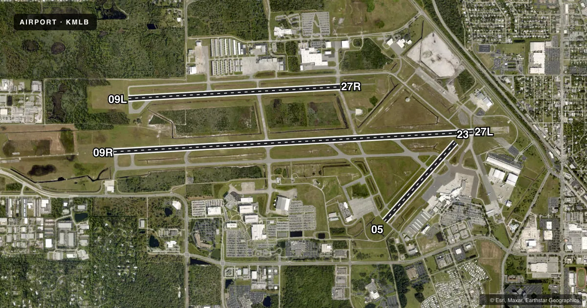
Runways & pattern
Full pagePattern entry · RWY 27L
LEFT TRAFFIC| Runway | Heading (°M) | Length | Surface | Traffic |
|---|---|---|---|---|
| 09R/27LFavored | 80° / 260° | 10,181 ft | ASPH | Standard L |
| 09L/27R | 80° / 260° | 6,000 ft | ASPH | Standard L |
| 05/23 | 35° / 215° | 3,001 ft | ASPH | Standard L |
Runway end performance
| End | TORA | TODA | ASDA | LDA | VGSI | Approach lights | Obstruction |
|---|---|---|---|---|---|---|---|
| 09R | 10,181' | 10,181' | 10,181' | 10,181' | PAPI 4-box left(3°) | MALSR | — |
| 27L | 10,181' | 10,181' | 10,181' | 9,482' | PAPI 4-box left(3°) | — | 36', trees, 1640' from thr, 420' R of cntrln, slope 40 |
| 09L | 6,000' | 6,000' | 6,000' | 6,000' | PAPI 4-box left(3°) | — | 26', trees, 550' from thr, 400' R of cntrln, slope 13 |
| 27R | 6,000' | 6,000' | 6,000' | 6,000' | PAPI 4-box left(3°) | — | 46', bldg, 1880' from thr, 450' R of cntrln, slope 36 |
| 05 | 3,001' | 3,001' | 3,001' | 3,001' | PAPI 2-box left(3°) | — | 41', trees, 1240' from thr, 135' R of cntrln, slope 25 |
| 23 | 3,001' | 3,001' | 3,001' | 3,001' | PAPI 2-box left(3°) | — | 45', hangar, 1370' from thr, 65' R of cntrln, slope 26 |
Declared distances in feet. TORA = takeoff run available, TODA = takeoff distance, ASDA = accelerate-stop, LDA = landing distance.
Airport sketch
Runways drawn to scale from FAA survey coordinates, rendered over satellite imagery. Not for navigation.
Approaches & charts
ILS · 1
Services on the field
Fuel grades, oxygen, maintenance, ramp storage and lighting — as declared to the FAA by the airport operator.
Fuel & services
- Fuel
- 100LLA
- Oxygen (bottled)
- Not available
- Airframe repair
- Major
- Power plant repair
- Major
- Other services
- AMB,AVNCS,CARGO,CHTR,INSTR,RNTL
Ramp & ground
- Transient storage
- Tie-down
- Hangar
- Landing fee
- No fee published
- Customs
- Not available
- Lighting schedule
- SEE RMK
- Beacon schedule
- SS-SR
- Beacon
- White / Green (civil land)(WG)
- Wind indicator
- Lighted
- Segmented circle
- Yes
Fuel & FBOs
Cheapest 100LL and Jet A on the field and nearby. Always confirm with the FBO before taxi.
Airport notes
Surface conditions, obstructions, local procedures, lighting outages and other notes published with each FAA cycle.
General notes
- TGL NA AFT 2100 OR 2 HR AFT SS; WHICHEVER IS LATER.
- RSTRD: MIL AIRCREW USE OF NORTHROP/GRUMMAN RAMP PPR - GRUMMAN OPS DSN 854-5245 EXTN 5522, C407-5522; PRIOR TO ARR - GRUMMAN OPS 123.2.
- UNCONTROLLED AREA TWY V WEST OF RWY 5; TWY C NORTH OF TWY K; TWY S NORTH OF S1; TWY H & G.
- SFC COND NOT RPRTD 2300-0600.
- BIRD ACT ON & INVOF ARPT.
- GA ACFT PRKG ON TRML APN PROHIBITED WITHOUT PPR FM ARPT MGMT.
- 24 HR ADVN NOTICE OR IMT REPORTING UPON LDG FOR ACFT EQUIPPED WITH WEATHER MODIFICATION OR GEOENGINEERING EQUIP CTC ARPT OPS 321-288-1578.
Lighting notes
- WHEN ATCT CLSD ACTVT MALSR RWY 9R; REIL RWY 27L; PAPI RWY 9R & 27L; MIRL 5/23 & 9L/27R; HIRL RWY 9R/27L - CTAF.
Runway surface & condition
- 05/23PCR VALUE: 100/F/B/X/T
- 09L/27RPCR VALUE: 170/F/B/X/T
- 09R/27LPCR VALUE: 580/F/B/X/T
- 05/23RWY 05/23 NOT AVBL FOR PART 121/PART 380 OPS WITH SKED PAX CARRYING OPS MORE THAN 9 PAX SEATS AND NON-SKED PAX CARRYING OPS MORE THAN 30 PAX SEATS.
- 09R/27L400 FT BLAST PAD BOTH RWY ENDS.
Approach & departure obstructions
- 09LTREES 20 FT TALL, 200 FT BFR AER, 404 RIGHT OF CNTRLN.
- 09RRVR UNAVBL 0000-0600.
- 27LRVR UNAVBL 0000-0600.
- 09LRWY 09L APCH SLP 34:1 TO AER.
VFR map & nearby airports
VFR sectional. Tap any ICAO chip to open that airport.
Key facts · KMLB
Answer card- ICAO
- KMLB
- Name
- MELBOURNE ORLANDO INTL
- Location
- MELBOURNE, FLORIDA
- Elevation
- 33.3 ft MSL
- Traffic pattern altitude
- 1,033.3 ft MSL (1,000 AGL)
- Control tower
- Towered · 0600-2400
- Total runways
- 3
- Longest runway
- 09R/27L · 10,181 ft
- Published ILS approaches
- 1
- Published frequencies
- 11
- Magnetic variation
- 7°
- Current flight rules
- VFR
- Current wind
- 270° at 9 kt
- Favored runway now
- RWY 27L
Melbourne Orlando Intl is in Melbourne, Florida. Field elevation is 33.3 ft MSL. The airport has 3 asphalt runways. The longest is 10,181 ft on 09R/27L. The tower is open 0600-2400. There is 1 ILS approach on runway 09R. Pattern altitude is not published. Use the standard 1,000 ft AGL for light piston traffic unless ATC or the current Chart Supplement says otherwise.
Sheltair is on the field. It carries 100LL, Jet A and Jet A Prist. FIT Aviation is also on the field. It carries 100LL. Bird activity is reported on and near the airport. That matters here because the field sits close to the coast and sees steady traffic. Runway 05/23 is not available for certain large scheduled or nonscheduled passenger operations. If you are planning a heavier arrival, check the current Chart Supplement and coordinate with the airport operator or FBO before you go. When the tower is closed, runway lighting and approach lighting are activated on CTAF. The field also has a published obstruction note near runway 09L. Verify your takeoff and landing plan before using that end.