METAR & TAF X21
Current METAR
Observed 13:35Z
KX21 271335Z AUTO 25005KT 10SM SCT110 26/26 A2989 RMK AO2
- Wind
- 250° @ 5 kt
- Visibility
- 10 SM
- Temp / Dew
- 26°C / 26°C
- Altimeter
- 29.89 inHg
- Clouds
- SCT
- Density alt
- 1,395 ft
- Ceiling
- Unlimited
- Rules
- VFR
Airport info & contacts
Manager on record, flight service, ARTCC, attendance schedule and pattern altitude — published by the FAA and refreshed every 28 days.
Location
- From city
- 2 NM NW
- VFR sectional
- JACKSONVILLE
- Pattern altitude
- 800 ft AGL · 830 ft MSL
- ARTCC
- ZJX · JACKSONVILLE
- NOTAM facility
- PIE (NOTAM-D)
Airport manager
- Name
- KEVIN DAUGHERTY
- Phone
- 321-267-8780
- Address
- 355 GOLDEN KNIGHTS BLVD, TITUSVILLE FL 32780
Flight service · Hours
- FSS PIE
- SAINT PETERSBURG1-800-WX-BRIEF
- Attendance
- 0800-2000
Frequencies
Tap any row to copy the frequency to your clipboard.
Runways & pattern
Full pagePattern entry · RWY 22
LEFT TRAFFIC| Runway | Heading (°M) | Length | Surface | Traffic |
|---|---|---|---|---|
| 15/33 | 144° / 324° | 3,026 ft | ASPH | Standard L |
| 04/22Favored | 27° / 207° | 1,805 ft | TURF | Standard L |
Runway end performance
| End | TORA | TODA | ASDA | LDA | VGSI | Approach lights | Obstruction |
|---|---|---|---|---|---|---|---|
| 15 | — | — | — | — | PAPI 2-box left(3.75°) | — | 51', pole, 1115' from thr, 145' R of cntrln, slope 17 |
| 33 | — | — | — | — | PAPI 2-box left(3.75°) | — | 45', trees, 445' from thr, 85' R of cntrln, slope 5 |
| 04 | — | — | — | — | — | — | 41', trees, 578' from thr, 35' R of cntrln, slope 14 |
| 22 | — | — | — | — | — | — | 56', trees, 815' from thr, 110' R of cntrln, slope 14 |
Declared distances in feet. TORA = takeoff run available, TODA = takeoff distance, ASDA = accelerate-stop, LDA = landing distance.
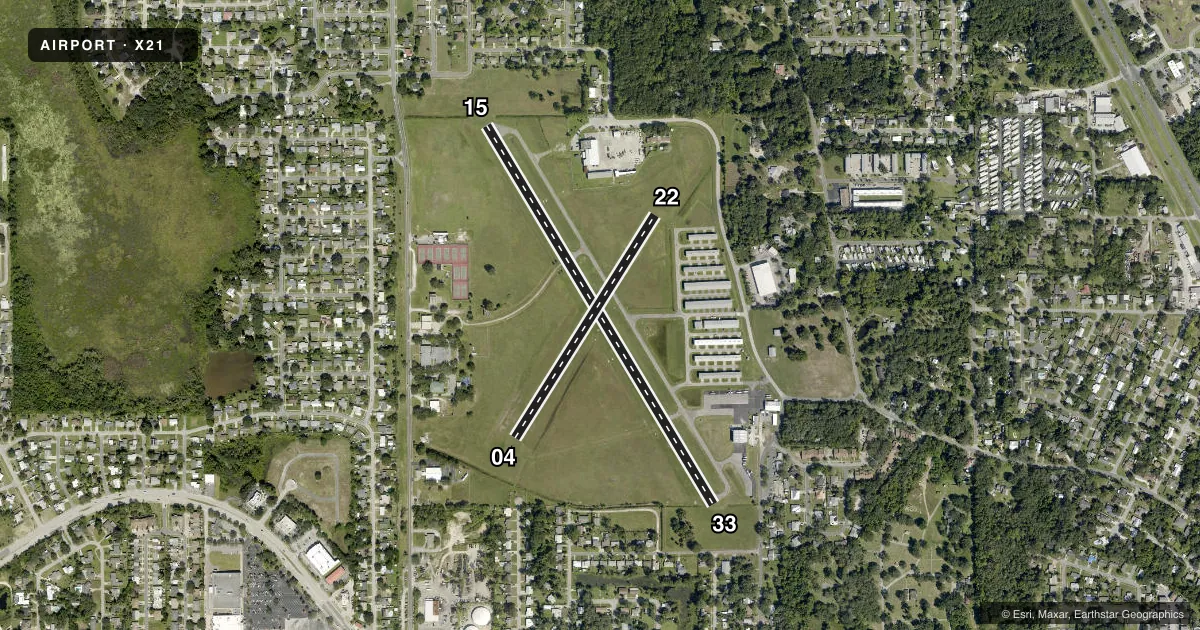
Airport sketch
Runways drawn to scale from FAA survey coordinates, rendered over satellite imagery. Not for navigation.
Approaches & charts
Services on the field
Fuel grades, oxygen, maintenance, ramp storage and lighting — as declared to the FAA by the airport operator.
Fuel & services
- Fuel
- 100LLA
- Oxygen (bottled)
- Not available
- Oxygen (bulk)
- Not available
- Airframe repair
- Major
- Power plant repair
- Major
- Other services
- PAJA
Ramp & ground
- Transient storage
- Tie-down
- Hangar
- Landing fee
- No fee published
- Customs
- Not available
- Lighting schedule
- SEE RMK
- Beacon schedule
- SS-SR
- Beacon
- White / Green (civil land)(WG)
- Wind indicator
- Lighted
Fuel & FBOs
Cheapest 100LL and Jet A on the field and nearby. Always confirm with the FBO before taxi.
Airport notes
Surface conditions, obstructions, local procedures, lighting outages and other notes published with each FAA cycle.
General notes
- EXTENSIVE ULTRALIGHT ACTIVITY INVOF ARPT.
- SVRL RADIO TOWERS 1.5 NM SOUTH OF FIELD; THE TALLEST TOWER IS 399 FT AGL.
- FOR INFO ON RY USE CALL ARPT AUTHORITY 321-267-8780.
- FOR CD OR TO CNL IFR CTC ORLANDO APCH AT 407-852-7500.
Lighting notes
- ACTVT PAPI RWY 33; MIRL RWY 15/33 - CTAF.
Runway surface & condition
- 04/22RY 04/22 RESTRICTED TO ULTRALIGHT AND STOL ACFT ONLY.
Approach & departure obstructions
- 04RWY 04/22 MKD WITH W CONES.
- 22RWY 04/22 MKD WITH W CONES.
- 15UNUSBL BYD 8 DEG RIGHT OF RCL.
- 04RY 04 APCH RATIO 20:1 TO DSPLCD THLD.
- 22RY 22 APCH RATIO 20:1 TO DSPLCD THLD.
- 33RY 33 APCH RATIO 20:1 TO DSPLCD THLD.
Other notes
- EXISTED PRIOR TO 1959.
- TPA FOR ULTRALIGHT ACFT 500 FT.
- OWNERCTC PERSON: KEVIN DAUGHERTY 321-267-8780.
- MANAGERFAX 321-383-4284
VFR map & nearby airports
VFR sectional. Tap any ICAO chip to open that airport.
Key facts · X21
Answer card- ICAO
- X21
- Name
- ARTHUR DUNN AIR PARK
- Location
- TITUSVILLE, FLORIDA
- Elevation
- 30.3 ft MSL
- Traffic pattern altitude
- 830.3 ft MSL (800 AGL)
- Control tower
- Non-towered (use CTAF)
- Total runways
- 2
- Longest runway
- 15/33 · 3,026 ft
- Published ILS approaches
- 0
- Published frequencies
- 4
- Magnetic variation
- 5°
- Current flight rules
- VFR
- Current wind
- 250° at 5 kt
- Favored runway now
- RWY 22
Arthur Dunn Air Park (X21) is in Titusville, Florida. Field elevation is 30.3 ft MSL. The airport has two runways. The longest is 15/33 at 3,026 ft. This is an untowered field, so use CTAF 123.0 for self-announce traffic and watch the pattern closely. Pattern altitude is 800 ft AGL, which is 830.3 ft MSL.
No ILS approaches are published here. Runway 15/33 is asphalt. Runway 04/22 is turf and marked with white cones. Runway 15 has a published limitation beyond 8 degrees right of centerline. The 33 end has medium intensity runway lights. The PAPI on runway 33 is activated. Published remarks also note an obstacle clearance slope issue on the 04, 22 and 33 approaches to the displaced thresholds. That is worth checking before you plan a short final.
Skydive Space Center is on the field. It carries AVGAS 100LL and Jet A. Call them at (321) 267-0016 for current fuel or ramp details. There is also extensive ultralight activity in the area. Several radio towers sit 1.5 NM south of the field. The tallest is 399 ft AGL. For runway use questions, call the airport authority at 321-267-8780 before you go.