METAR & TAF KTNT
KTNT does not publish a METAR.
Showing the nearest reporting station: KTMB (MIAMI EXEC) · 28.2 NM away. Conditions at KTNT may differ.
METAR · KTMB
Observed 12:53Z
KTMB 271253Z 23004KT 10SM FEW023 28/26 A2997 RMK AO2 LTG DSNT SW AND W SLP149 T02780256
- Wind
- 230° @ 4 kt
- Visibility
- 10 SM
- Temp / Dew
- 28°C / 26°C
- Altimeter
- 29.97 inHg
- Clouds
- FEW
- Density alt
- 1,514 ft
- Ceiling
- Unlimited
- Rules
- VFR
Airport info & contacts
Manager on record, flight service, ARTCC, attendance schedule and pattern altitude — published by the FAA and refreshed every 28 days.
Location
- From city
- 36 NM W
- VFR sectional
- MIAMI
- ARTCC
- ZMA · MIAMI
- NOTAM facility
- MIA (NOTAM-D)
Airport manager
- Name
- JOSEPH KINNEBREW
- Phone
- 305-876-7484
- Address
- PO BOX 025504, MIAMI FL 33102-5504
Flight service · Hours
- FSS MIA
- MIAMI1-800-WX-BRIEF
- Attendance
- WED · SAT · 0800-1800
Frequencies
Tap any row to copy the frequency to your clipboard.
Runways & pattern
Full pagePattern entry · RWY 27
RIGHT TRAFFICRunway end performance
| End | TORA | TODA | ASDA | LDA | VGSI | Approach lights | Obstruction |
|---|---|---|---|---|---|---|---|
| 09 | — | — | — | — | — | — | 10', road, 400' from thr, 193' R of cntrln, slope 20 |
| 27 | — | — | — | — | — | — | 26', trees, 1075' from thr, 290' R of cntrln, slope 34 |
Declared distances in feet. TORA = takeoff run available, TODA = takeoff distance, ASDA = accelerate-stop, LDA = landing distance.
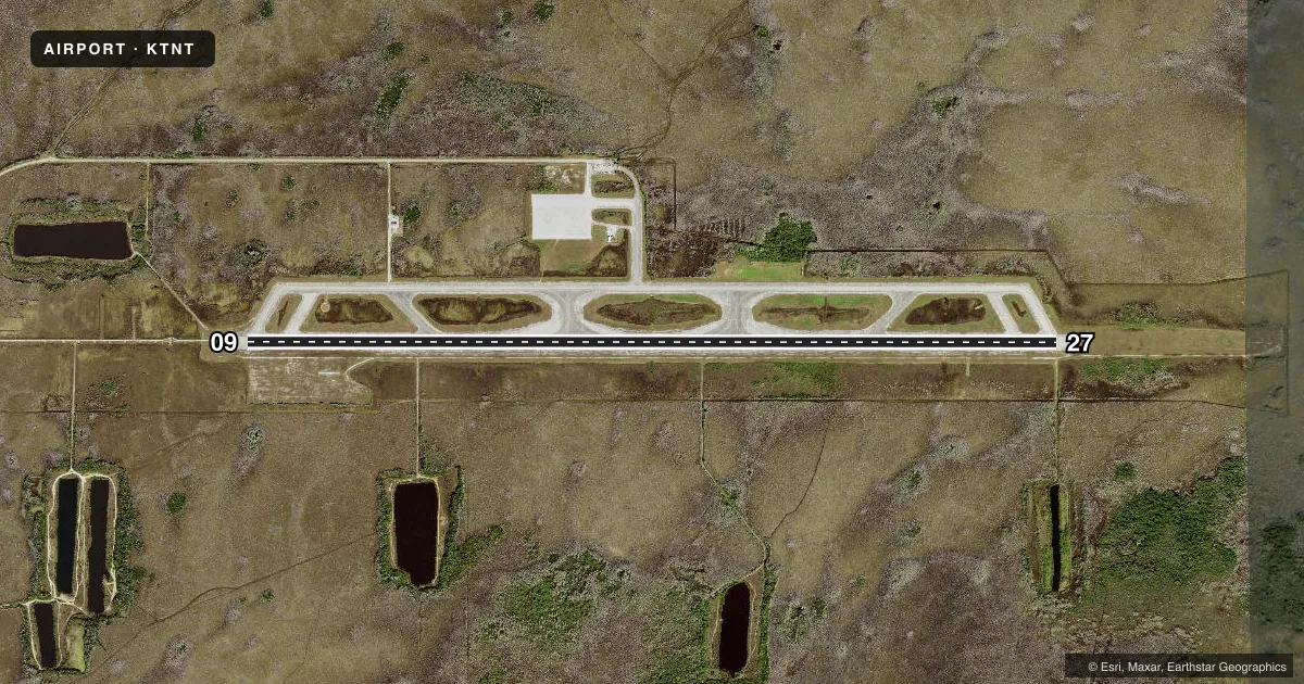
Airport sketch
Runways drawn to scale from FAA survey coordinates, rendered over satellite imagery. Not for navigation.
Approaches & charts
Services on the field
Fuel grades, oxygen, maintenance, ramp storage and lighting — as declared to the FAA by the airport operator.
Fuel & services
- Fuel
- Not available
- Oxygen (bottled)
- Not available
- Oxygen (bulk)
- Not available
- Airframe repair
- Not available
- Power plant repair
- Not available
Ramp & ground
- Transient storage
- Not published
- Landing fee
- Yes
- Customs
- Not available
- Beacon schedule
- SS-SR
- Beacon
- White / Green (civil land)(WG)
- Wind indicator
- Lighted
Fuel & FBOs
Cheapest 100LL and Jet A on the field and nearby. Always confirm with the FBO before taxi.
Airport notes
Surface conditions, obstructions, local procedures, lighting outages and other notes published with each FAA cycle.
General notes
- THREE 8IN WELLS FLUSH MTD BTN RWY AND TWY.
- FEE FOR USE FOR ACFT OVER 12500 LBS.
- BE ALERT TO LOW FLYING NATIONAL PARK SVC ACFT ALL QUADRANTS.
- NO NGT TIME OPNS EXC WITH PRIOR PMSN FM MIAMI-DADE AVN DEPT 305-869-1660.
- FOR CD IF UNA TO CTC ON FSS FREQ, CTC MIAMI APCH AT 305-869-5432.
- WILDLIFE ON AND INVOF ARPT.
- 24 HR PPR FOR ACFT EQUIPPED WITH WEATHER MODIFICATION OR GEOENGINEERING EQPT 305-793-3158.
Other notes
- ACR TRNG OPNS ONLY.
- AND COLLIER CO.
- ARPT CLSD TO PUBLIC EXCP BY ARRANGEMENT WITH MIAMI-DADE AVIATION DEPT MIAMI 305-869-1660.
- MANAGERAIRPORT PHYSICAL ADDRESS: 54757 EAST TAMIAMI TRAIL, OCHOPPI, FL 34141 239-695-3300, FAX: 305-876-0565
VFR map & nearby airports
VFR sectional. Tap any ICAO chip to open that airport.
Key facts · KTNT
Answer card- ICAO
- KTNT
- Name
- DADE-COLLIER TRAINING AND TRANSITION
- Location
- MIAMI, FLORIDA
- Elevation
- 12.7 ft MSL
- Traffic pattern altitude
- 1,012.7 ft MSL (1,000 AGL)
- Control tower
- Non-towered (use CTAF)
- Total runways
- 1
- Longest runway
- 09/27 · 10,499 ft
- Published ILS approaches
- 0
- Published frequencies
- 4
- Magnetic variation
- 5°
- Current flight rules
- VFR
- Current wind
- 230° at 4 kt
- Favored runway now
- RWY 27
Dade-Collier Training and Transition (KTNT) sits in Miami, Florida. The field elevation is 12.7 ft MSL. It has one runway, 09/27, which is 10,499 ft long. There is no control tower. No ILS approaches are published here. Pattern altitude is not published, so use standard 1,000 ft AGL for light piston traffic unless the current Chart Supplement says otherwise.
This is a training airport only. The field is closed to the public except by arrangement with Miami-Dade Aviation Department. No nighttime operations are allowed unless you have prior permission from the department. Be alert for low-flying National Park Service aircraft in all quadrants. Wildlife is also present on and near the airport. There are three 8-inch wells flush mounted between the runway and taxiway, so keep a sharp scan during ground movement.
No on-field FBOs are listed. For clearance delivery, if you cannot reach Flight Service, contact Miami Approach. The airport is also subject to a fee for aircraft over 12,500 pounds. Pilots planning to use KTNT should verify current access, operating limits and any local procedures with the airport operator before arrival.