METAR & TAF X44
X44 does not publish a METAR.
Showing the nearest reporting station: KMIA (MIAMI INTL) · 6.6 NM away. Conditions at X44 may differ.
METAR · KMIA
Observed 07:53Z
KMIA 270753Z VRB03KT 10SM FEW090 FEW250 26/23 A2994 RMK AO2 SLP138 T02560228 $
- Wind
- VAR @ 3 kt
- Visibility
- 10 SM
- Temp / Dew
- 26°C / 23°C
- Altimeter
- 29.94 inHg
- Clouds
- FEW
- Density alt
- 1,303 ft
- Ceiling
- Unlimited
- Rules
- VFR
Airport info & contacts
Manager on record, flight service, ARTCC, attendance schedule and pattern altitude — published by the FAA and refreshed every 28 days.
Location
- From city
- 2 NM E
- VFR sectional
- MIAMI
- ARTCC
- ZMA · MIAMI
- NOTAM facility
- MIA (NOTAM-D)
Airport manager
- Name
- IGNACIO VEGA-PENICHET
- Phone
- 305-442-4444
- Address
- 1000 MACARTHUR CAUSEWAY, 444 SW 2ND AVE, MIAMI FL 33132
Flight service · Hours
- FSS MIA
- MIAMI1-800-WX-BRIEF
- Attendance
- DALGT
Frequencies
Tap any row to copy the frequency to your clipboard.
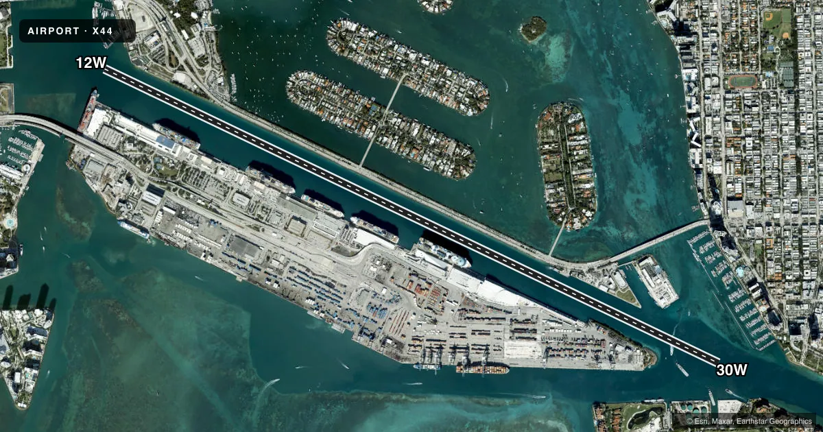
Runways & pattern
Full pagePattern entry · RWY 30W
LEFT TRAFFICAirport sketch
Runways drawn to scale from FAA survey coordinates, rendered over satellite imagery. Not for navigation.
Approaches & charts
Services on the field
Fuel grades, oxygen, maintenance, ramp storage and lighting — as declared to the FAA by the airport operator.
Fuel & services
- Fuel
- Not available
- Oxygen (bottled)
- Not available
- Oxygen (bulk)
- Not available
- Airframe repair
- Not available
- Power plant repair
- Not available
Ramp & ground
- Transient storage
- Not published
- Landing fee
- No fee published
- Customs
- Available
- Wind indicator
- Yes
- Segmented circle
- No
Fuel & FBOs
Cheapest 100LL and Jet A on the field and nearby. Always confirm with the FBO before taxi.
Airport notes
Surface conditions, obstructions, local procedures, lighting outages and other notes published with each FAA cycle.
General notes
- 500 FT RDO TWR 3/4MI W OF BASE.
- NUMEROUS WATERCRAFT AND LARGE PASSENGER VESSELS IN AREA.
- FOR CD CTC MIAMI APCH AT 305-869-5432.
- HELI PRKG ON SPB RAMP BY PPR ONLY.
- USE CTN FOR HEL OPR AT WATSON ISLAND HELIPORT (89FA) ON ADJACENT PROPERTY TO SPB.
Other notes
- EXISTED PRIOR TO 1959.
- ALL TERMINAL FACILITIES ARE PRIVATE USE.
- WIND SOCK LCTD ADJACENT TO RAMP.
- MANAGERALT CTC: INFO@MIAMISEAPLANEBASE.COM
VFR map & nearby airports
VFR sectional. Tap any ICAO chip to open that airport.
Key facts · X44
Answer card- ICAO
- X44
- Name
- MIAMI
- Location
- MIAMI, FLORIDA
- Elevation
- 6 ft MSL
- Traffic pattern altitude
- 1,006 ft MSL (1,000 AGL)
- Control tower
- Non-towered (use CTAF)
- Total runways
- 1
- Longest runway
- 12W/30W · 14,000 ft
- Published ILS approaches
- 0
- Published frequencies
- 2
- Magnetic variation
- 3°
- Current flight rules
- VFR
- Current wind
- 000° at 3 kt
- Favored runway now
- RWY 30W
MIAMI (X44) sits in Miami, Florida at 6 ft MSL. It has one runway, 12W/30W, which is 14,000 ft long on water. The field is in Class C airspace. There is no control tower on the field. No ILS approaches are published here. The pattern altitude is not published. Use 1,000 ft AGL as the standard light piston pattern unless the current Chart Supplement says otherwise.
This is a water airport, so expect traffic on the surface as well as in the air. The published remarks call out numerous watercraft and large passenger vessels in the area. That matters for your scan on final and in the pattern. A 500-foot radio tower sits about three quarters of a mile west of the base. The wind sock is adjacent to the ramp. All terminal facilities are private use.
There are no on-field FBOs listed in the facts. FBO options vary. Contact the airport operator directly before arrival. Call the field on CTAF or UNICOM for current FBO availability. For clearance delivery, contact Miami Approach at 305-869-5432. If you are planning a first arrival here, get the current Chart Supplement and brief the water operations. Brief the nearby tower. Brief the private-use terminal setup before you launch.