METAR & TAF X51
X51 does not publish a METAR.
Showing the nearest reporting station: KTMB (MIAMI EXEC) · 11.1 NM away. Conditions at X51 may differ.
METAR · KTMB
Observed 10:53Z
KTMB 271053Z AUTO 00000KT 10SM CLR 23/23 A2995 RMK AO2 SLP141 T02280228 $
- Wind
- 000° @ 0 kt
- Visibility
- 10 SM
- Temp / Dew
- 23°C / 23°C
- Altimeter
- 29.95 inHg
- Clouds
- CLR
- Density alt
- 931 ft
- Ceiling
- Unlimited
- Rules
- VFR
Airport info & contacts
Manager on record, flight service, ARTCC, attendance schedule and pattern altitude — published by the FAA and refreshed every 28 days.
Location
- From city
- 4 NM NW
- VFR sectional
- MIAMI
- ARTCC
- ZMA · MIAMI
- NOTAM facility
- MIA (NOTAM-D)
Airport manager
- Name
- JOSEPH KINNEBREW
- Phone
- 305-876-7484
- Address
- 12800 SOUTHWEST 145TH AVENUE, MIAMI FL 33186
Flight service · Hours
- FSS MIA
- MIAMI1-800-WX-BRIEF
- Attendance
- 0800-1800
Frequencies
Tap any row to copy the frequency to your clipboard.
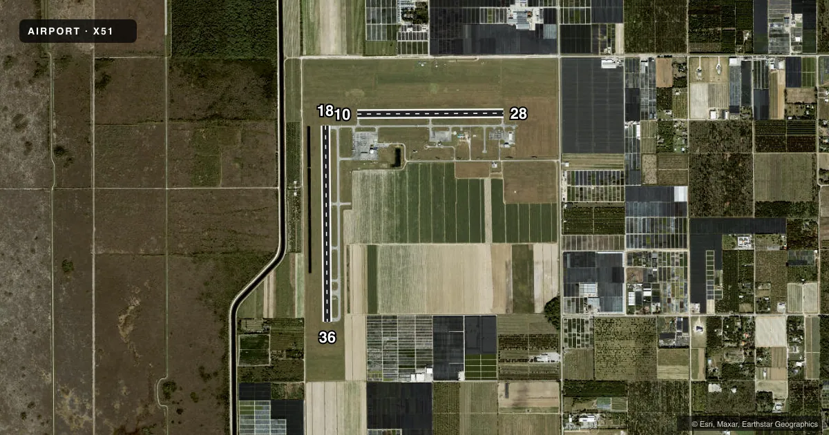
Runways & pattern
Full pagePattern entry · RWY 18
RIGHT TRAFFIC| Runway | Heading (°M) | Length | Surface | Traffic |
|---|---|---|---|---|
| 18/36 | 173° / 353° | 4,001 ft | ASPH | 18 R |
| 10/28 | 84° / 264° | 3,000 ft | ASPH | 28 R |
Runway end performance
| End | TORA | TODA | ASDA | LDA | VGSI | Approach lights | Obstruction |
|---|---|---|---|---|---|---|---|
| 36 | — | — | — | — | PAPI 4-box right(3°) | — | — |
| 10 | — | — | — | — | PAPI 2-box left(3°) | — | 22', tree, 1270' from thr, 225' R of cntrln, slope 50 |
Declared distances in feet. TORA = takeoff run available, TODA = takeoff distance, ASDA = accelerate-stop, LDA = landing distance.
Airport sketch
Runways drawn to scale from FAA survey coordinates, rendered over satellite imagery. Not for navigation.
Approaches & charts
Services on the field
Fuel grades, oxygen, maintenance, ramp storage and lighting — as declared to the FAA by the airport operator.
Fuel & services
- Fuel
- 100LLA
- Oxygen (bottled)
- Low pressure
- Airframe repair
- Major
- Power plant repair
- Major
- Other services
- CHTR,GLD,INSTR,PAJA,RNTL,SALES,SURV,TOW
Ramp & ground
- Transient storage
- Tie-down
- Hangar
- Landing fee
- No fee published
- Customs
- Not available
- Lighting schedule
- SS-SR
- Beacon schedule
- SS-SR
- Beacon
- White / Green (civil land)(WG)
- Wind indicator
- Lighted
Fuel & FBOs
Cheapest 100LL and Jet A on the field and nearby. Always confirm with the FBO before taxi.
Airport notes
Surface conditions, obstructions, local procedures, lighting outages and other notes published with each FAA cycle.
General notes
- PAJA SE CORNER OF ARPT .
- AEROBATIC BOX S OF ARPT & E OF RWY 18/36.
- REMOTE CTL MODEL FLYING FLDS 1.8 NM N RWY 18.
- GLIDER ACT 8000 FT & BLW & CROP DUSTING INVOF ARPT.
- FOR CD CTC MIAMI APCH AT 305-869-5432.
- 24 HR PPR FOR ACFT EQUIPPED WITH WEATHER MODIFICATION OR GEOENGINEERING EQPT 305-247-4883
Approach & departure obstructions
- 09UMKD WITH WHITE CONES.
- 27UMKD WITH WHITE CONES.
Other notes
- VFR ONLY.
- OWNERCONTACT PERSON: LIONEL BECKLES
VFR map & nearby airports
VFR sectional. Tap any ICAO chip to open that airport.
Key facts · X51
Answer card- ICAO
- X51
- Name
- MIAMI HOMESTEAD GENERAL AVIATION
- Location
- HOMESTEAD, FLORIDA
- Elevation
- 7 ft MSL
- Traffic pattern altitude
- 1,007 ft MSL (1,000 AGL)
- Control tower
- Non-towered (use CTAF)
- Total runways
- 2
- Longest runway
- 18/36 · 4,001 ft
- Published ILS approaches
- 0
- Published frequencies
- 4
- Magnetic variation
- 6°
- Current flight rules
- VFR
- Current wind
- 000° at 0 kt
- Favored runway now
- –
Miami Homestead General Aviation is in Homestead, Florida. The field elevation is 7 ft MSL. It has two asphalt runways. The longest is runway 18/36 at 4,001 ft. Runway 10/28 is 3,000 ft. There is no control tower. CTAF and UNICOM are both 122.8. Miami Approach also handles clearance delivery and departure services on 125.5 and 354.1.
No ILS approaches are published here. The airport is VFR only. Pattern altitude is not published, so use the standard 1,000 ft AGL for light piston traffic unless the current Chart Supplement says otherwise. Homestead Executive Jet Center is on the field. It carries 100LL and Jet A Prist. Contact the FBO directly for current availability before you go.
A first-time pilot should pay attention to the local traffic picture. Glider activity occurs at 8,000 ft and below. Crop dusting is also in the vicinity. There is an aerobatic box south of the airport and east of runway 18/36. Remote control model flying fields are 1.8 NM north of runway 18. If you need clearance delivery details, Miami Approach is listed in the remarks. Check the current Chart Supplement for any operational updates before departure.