METAR & TAF KMIA
Current METAR
Observed 09:53Z
KMIA 270953Z 00000KT 10SM FEW025 FEW100 BKN250 26/23 A2995 RMK AO2 SLP141 T02560233 $
- Wind
- 000° @ 0 kt
- Visibility
- 10 SM
- Temp / Dew
- 26°C / 23°C
- Altimeter
- 29.95 inHg
- Clouds
- BKN
- Density alt
- 1,294 ft
- Ceiling
- 25,000 ft AGL
- Rules
- VFR
Airport info & contacts
Manager on record, flight service, ARTCC, attendance schedule and pattern altitude — published by the FAA and refreshed every 28 days.
Location
- From city
- 8 NM NW
- VFR sectional
- MIAMI
- ARTCC
- ZMA · MIAMI
- NOTAM facility
- MIA (NOTAM-D)
Airport manager
- Name
- RALPH CUTIE
- Phone
- 305-876-7038
- Address
- MIAMI-DADE AVIATION DEPARTMENT, P.O. BOX 025504, MIAMI FL 33102-5504
Flight service · Hours
- FSS MIA
- MIAMI1-800-WX-BRIEF
- Attendance
- ALL
Frequencies
Tap any row to copy the frequency to your clipboard.
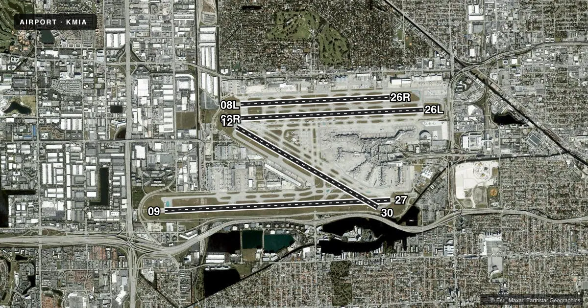
Runways & pattern
Full pagePattern entry · RWY 09
RIGHT TRAFFIC| Runway | Heading (°M) | Length | Surface | Traffic |
|---|---|---|---|---|
| 09/27 | 82° / 262° | 13,016 ft | ASPH | 09 R |
| 08R/26L | 82° / 262° | 10,506 ft | ASPH | 26L R |
| 12/30 | 114° / 294° | 9,360 ft | ASPH | Standard L |
| 08L/26R | 82° / 262° | 8,600 ft | ASPH | Standard L |
Runway end performance
| End | TORA | TODA | ASDA | LDA | VGSI | Approach lights | Obstruction |
|---|---|---|---|---|---|---|---|
| 09 | 13,016' | 13,016' | 12,755' | 11,397' | PAPI 4-box left(3°) | MALSR | 23', rr, 750' from thr, 580' R of cntrln, slope 23 |
| 27 | 13,016' | 13,016' | 13,016' | 12,755' | PAPI 4-box left(3°) | MALSR | — |
| 08R | 10,506' | 10,506' | 10,506' | 10,506' | PAPI 4-box left(3°) | MALSR | — |
| 26L | 10,506' | 10,506' | 10,220' | 10,220' | PAPI 4-box left(3°) | MALSF | — |
| 12 | 9,355' | 9,355' | 8,579' | 8,579' | PAPI 4-box right(3°) | MALSR | 40', tower, 1700' from thr, 200' R of cntrln, slope 37 |
| 30 | 9,355' | 9,355' | 8,853' | 7,913' | PAPI 4-box left(3°) | MALS | 52', tree, 1600' from thr, 300' R of cntrln, slope 26 |
| 08L | 8,600' | 8,600' | 8,600' | 8,600' | PAPI 4-box left(3°) | — | — |
| 26R | 8,600' | 8,600' | 8,600' | 8,600' | PAPI 4-box left(3°) | — | — |
Declared distances in feet. TORA = takeoff run available, TODA = takeoff distance, ASDA = accelerate-stop, LDA = landing distance.
Airport sketch
Runways drawn to scale from FAA survey coordinates, rendered over satellite imagery. Not for navigation.
Approaches & charts
ILS · 8
Services on the field
Fuel grades, oxygen, maintenance, ramp storage and lighting — as declared to the FAA by the airport operator.
Fuel & services
- Fuel
- 100A
- Oxygen (bottled)
- HIGH/LOW
- Oxygen (bulk)
- HIGH/LOW
- Airframe repair
- Major
- Power plant repair
- Major
- Other services
- AFRT,AGRI,CARGO,CHTR
Ramp & ground
- Transient storage
- Tie-down
- Hangar
- Landing fee
- Yes
- Customs
- Available
- Beacon schedule
- SS-SR
- Beacon
- White / Green (civil land)(WG)
- Wind indicator
- Lighted
- Segmented circle
- No
Fuel & FBOs
Cheapest 100LL and Jet A on the field and nearby. Always confirm with the FBO before taxi.
Airport notes
Surface conditions, obstructions, local procedures, lighting outages and other notes published with each FAA cycle.
General notes
- CLSD NON ENG ACFT.
- BIRDS ON & INVOF ARPT.
- PPR 3 HRS PRIOR TO ALL ARRIVALS ON THE GENERAL AVIATION CENTER (GAC) RAMP 305-876-7550 CTC RAMP CONTROL UPON ARRIVAL ON FREQUENCY 131.600. ACFT WITH WINGSPAN GREATER THAN 78 FT ARE PROHIBITED FROM ENTERING THE GAC RAMP.
- ALL MEDICAL EMERGENCIES ARRIVALS, WITH THE EXCEPTION OF AIR AMBULANCE FLIGHTS, MUST SECURE DOORS UNTIL ARFF IS ON SCENE.
- PPR FOR INBOUND MILITARY FLIGHTS 100 NM ON FREQ 130.5.
- ALL DIVERSION CTC FREQ 130.5 UPON ARR.
- AIRPORT MANAGER: 305-876-7038.
- AIRPORT OPS 305-876-7550.
- US CBP AND EAPIS AVBL.
- RWY 12-30 CLSD 0300-1200Z++ WHEN RWY 08R-26L AND RWY 09-27 ARE IN USE.
- RWY 08L-26R CLSD 0300-1200Z++ WHEN RWY 08R-26L AND RWY 09-27 ARE IN USE.
- ALL TBJT ACFT ARE REQD TO USE DSNT NOISE ABATEMENT DEP PROFILE (NADP-2) FROM ALL RWYS.
- ACFT WITH A WINGSPAN GTR THAN 171 FT ARE PROHIBITED FM TXG ON TWY P E OF TWY U, EXCEPT ADG VI ACFT COMPLYING WITH MIA ADG VI OPERATIONAL PLAN WHEN ADJ AIRSIDE SVC ROAD IS CLSD TO TRAFFIC.
- TRML APN TXY SPOTS 2, 4, 13,15, 22 AND 24 MAX SPAN 125 FT OR LESS. TRML APN TXY SPOTS 26, 28 MAX SPAN 167 FT OR LESS
- 24 HR PPR FOR ACFT EQUIPPED WITH WEATHER MODIFICATION OR GEOENGINEERING EQPT 305-876-7550.
Runway surface & condition
- 08L/26RPCR VALUE: 711/F/A/X/T
- 08R/26LPCR VALUE: 851/F/A/X/T
- 09/27PCR VALUE: 851/F/A/X/T
- 12/30PCR VALUE: 780/F/A/X/T
- 08L/26RRWY 08L/26R CLSD 0300-1200++ WHEN RWY 08R/26L & RWY 09/27 ARE IN USE.
- 12/30RWY 12/30 CLSD 0300-1200++ WHEN RWY 08R/26L & RWY 09/27 ARE IN USE.
Approach & departure obstructions
- 30+20' RR 200' FM RY END; 450'L.
- 09APCH RATIO 50:1 TO DSPLCD THR.
- 30APCH RATIO 48:1 TO DSPLCD THR.
Other notes
- MANAGERADRIAN DIAZ, AIRPORT SUPERVISOR 305-876-7674.
VFR map & nearby airports
VFR sectional. Tap any ICAO chip to open that airport.
Key facts · KMIA
Answer card- ICAO
- KMIA
- Name
- MIAMI INTL
- Location
- MIAMI, FLORIDA
- Elevation
- 9.3 ft MSL
- Traffic pattern altitude
- 1,009.3 ft MSL (1,000 AGL)
- Control tower
- Towered · 24
- Total runways
- 4
- Longest runway
- 09/27 · 13,016 ft
- Published ILS approaches
- 8
- Published frequencies
- 23
- Magnetic variation
- 5°
- Current flight rules
- VFR
- Current wind
- 000° at 0 kt
- Favored runway now
- –
KMIA is Miami Intl in Miami, Florida. The field elevation is 9.3 ft MSL. It has four runways. The longest is 13,016 ft. The tower is open 24 hours. Eight ILS approaches are published. The listed runway ends are 08L, 08R, 09, 12, 26L, 26R, 27 and 30. The published pattern altitude is not listed, so use 1,000 ft AGL for light piston traffic unless ATC or the current Chart Supplement says otherwise.
Signature Aviation is on the field. It carries 100LL and Jet A. Call the FBO directly at (305) 874-1477 for current services. Airport operations can be reached at 305-876-7550. This is a busy Class B environment. Expect heavy airline traffic. Expect tight sequencing. Expect close attention to taxi instructions. The published remarks also note a closure on runway 08L/26R from 0300 to 1200. It can extend beyond that when 08R/26L and 09/27 are in use. That matters for planning. There is also a displaced-threshold obstruction note for runway 09 and runway 30. If you are bringing a large aircraft, review the wingspan limits and ramp restrictions before you go. First-time arrivals should brief the current Chart Supplement and be ready for complex ground movement at a major airline airport.