METAR & TAF KHWO
Current METAR
Observed 11:53Z
KHWO 271153Z 27003KT 10SM CLR 26/26 A2996 RMK AO2 SLP142 T02610261 $
- Wind
- 270° @ 3 kt
- Visibility
- 10 SM
- Temp / Dew
- 26°C / 26°C
- Altimeter
- 29.96 inHg
- Clouds
- CLR
- Density alt
- 1,281 ft
- Ceiling
- Unlimited
- Rules
- VFR
Airport info & contacts
Manager on record, flight service, ARTCC, attendance schedule and pattern altitude — published by the FAA and refreshed every 28 days.
Location
- From city
- 5 NM W
- VFR sectional
- MIAMI
- Pattern altitude
- 800 ft AGL · 809 ft MSL
- ARTCC
- ZMA · MIAMI
- NOTAM facility
- HWO (NOTAM-D)
Airport manager
- Name
- NINA MACPHERSON
- Phone
- 954-359-1016
- Address
- 101 SOUTHWEST 77TH WAY, PEMBROKE PINES FL 33023
Flight service · Hours
- FSS MIA
- MIAMI1-800-WX-BRIEF
- Attendance
- 0700-2000
Frequencies
Tap any row to copy the frequency to your clipboard.
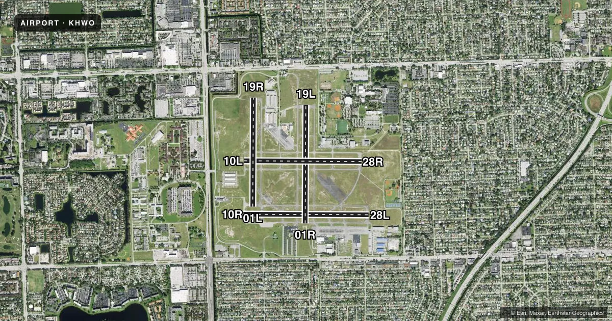
Runways & pattern
Full pagePattern entry · RWY 28L
LEFT TRAFFIC| Runway | Heading (°M) | Length | Surface | Traffic |
|---|---|---|---|---|
| 10R/28LFavored | 84° / 264° | 3,463 ft | ASPH | 10R R |
| 01R/19L | 354° / 174° | 3,260 ft | ASPH | 01R R |
| 10L/28R | 84° / 264° | 3,241 ft | ASPH | 28R R |
| 01L/19R | 354° / 174° | 3,000 ft | ASPH | 19R R |
Runway end performance
| End | TORA | TODA | ASDA | LDA | VGSI | Approach lights | Obstruction |
|---|---|---|---|---|---|---|---|
| 10R | 3,463' | 3,463' | 3,463' | 2,999' | PAPI 4-box left(3.5°) | — | 59', bldg, 1618' from thr, 35' R of cntrln, slope 24 |
| 28L | 3,463' | 3,463' | 3,463' | 3,253' | PAPI 2-box left(3.5°) | — | 47', tree, 1005' from thr, 215' R of cntrln, slope 17 |
| 01R | — | — | — | — | PAPI 2-box left(3.5°) | — | 50', trees, 1060' from thr, 140' R of cntrln, slope 17 |
| 19L | — | — | — | — | PAPI 2-box left(3.5°) | — | 54', tree, 1380' from thr, 125' R of cntrln, slope 21 |
| 10L | — | — | — | — | PAPI 2-box left(3.5°) | — | 63', tree, 1335' from thr, 165' R of cntrln, slope 18 |
| 28R | — | — | — | — | PAPI 2-box left(3.5°) | — | 42', trees, 1145' from thr, 75' R of cntrln, slope 23 |
| 01L | — | — | — | — | PAPI 2-box left(3.5°) | — | 45', tree, 1170' from thr, 85' R of cntrln, slope 21 |
| 19R | — | — | — | — | PAPI 2-box left(3.5°) | — | 51', trees, 1125' from thr, 175' R of cntrln, slope 18 |
Declared distances in feet. TORA = takeoff run available, TODA = takeoff distance, ASDA = accelerate-stop, LDA = landing distance.
Airport sketch
Runways drawn to scale from FAA survey coordinates, rendered over satellite imagery. Not for navigation.
Approaches & charts
Services on the field
Fuel grades, oxygen, maintenance, ramp storage and lighting — as declared to the FAA by the airport operator.
Fuel & services
- Fuel
- 100LLA
- Oxygen (bottled)
- Not available
- Oxygen (bulk)
- Not available
- Airframe repair
- Major
- Power plant repair
- Major
- Other services
- AVNCS,CHTR,INSTR,RNTL,SALES
Ramp & ground
- Transient storage
- Tie-down
- Hangar
- Landing fee
- No fee published
- Customs
- Not available
- Lighting schedule
- SEE RMK
- Beacon schedule
- SS-SR
- Beacon
- White / Green (civil land)(WG)
- Wind indicator
- Lighted
Fuel & FBOs
Cheapest 100LL and Jet A on the field and nearby. Always confirm with the FBO before taxi.
Airport notes
Surface conditions, obstructions, local procedures, lighting outages and other notes published with each FAA cycle.
General notes
- ARPT CLSD TO ACFT OVER 12500 LBS MAX CERTD TOG.
- NUMEROUS TALL TOWERS SE OF ARPT CAUSE RADIO INTFC.
- HIGH VOL OF BANNER TOWING AND STUDENT FLT INVOF ARPT.
- BIRD ACTIVITY ON & INVOF AIRPORT.
- RWY CONDITION NOT MONITORED WHEN TOWER CLOSED.
- 24 HR PPR FOR ACFT EQUIPPED WITH WEATHER MODIFICATION OR GEOENGINEERING EQPT 954-336-2973.
Lighting notes
- ATC-CTL. WHEN ATCT CLSD ACTVT MIRL RWY 10R/28L, 01L/19R - CTAF.
Approach & departure obstructions
- 01RRWY 01R APCH SLOPE 25:1 TO THE DSPLCD THR.
- 10LRWY 10L APCH SLOPE 25:1 TO THE DSPLCD THR.
- 10RRY 10R APCH SLOPE 32:1 TO THE DSPLCD THLD.
- 19RRWY 19R APCH SLOPE 28:1 TO THE DSPLCD THR.
- 28LRWY 28L APCH SLOPE 25:1 TO THE DSPLCD THR.
- 28RRWY 28R APCH SLOPE 31:1 TO THE DSPLCD THR.
Other notes
- VFR OPERS ONLY
- OWNERCONTACT PERSON: MARK GALE A.A.E. 954-359-6100
VFR map & nearby airports
VFR sectional. Tap any ICAO chip to open that airport.
Key facts · KHWO
Answer card- ICAO
- KHWO
- Name
- NORTH PERRY
- Location
- HOLLYWOOD, FLORIDA
- Elevation
- 8.5 ft MSL
- Traffic pattern altitude
- 808.5 ft MSL (800 AGL)
- Control tower
- Towered · 0700-2100
- Total runways
- 4
- Longest runway
- 10R/28L · 3,463 ft
- Published ILS approaches
- 0
- Published frequencies
- 10
- Magnetic variation
- 6°
- Current flight rules
- VFR
- Current wind
- 270° at 3 kt
- Favored runway now
- RWY 28L
North Perry (KHWO) is in Hollywood, Florida. The field elevation is 8.5 ft MSL. It has four asphalt runways. The longest is 10R/28L at 3,463 ft. The airport has a control tower. Tower hours are 0700 to 2100. No ILS approaches are published here. Pattern altitude is 800 ft AGL, which is 808.5 ft MSL.
On the field you will find North Perry Central, The Fuel Depot at Bobby's Landing and Hollywood Aviation. North Perry Central carries 100LL. The Fuel Depot at Bobby's Landing carries 100LL and Jet A. Hollywood Aviation carries 100LL. This is a busy training airport. Expect a lot of student traffic and banner towing in the area. The airport is VFR only. It is also closed to aircraft over 12,500 pounds maximum certified takeoff gross weight.
A few operational items matter here. Runway condition is not monitored when the tower is closed. The tower controls the lighting. When the tower is closed, medium intensity runway lights on 10R/28L and 01L/19R are activated on the CTAF. There are also tall towers southeast of the airport that can cause radio interference. Watch the approach slopes on 28R, 28L and 19R. Check the current FAA Chart Supplement and call the airport operator or FBO directly if you need anything current before departure.