METAR & TAF X01
X01 does not publish a METAR.
Showing the nearest reporting station: KMKY (MARCO ISLAND EXEC) · 17.6 NM away. Conditions at X01 may differ.
METAR · KMKY
Observed 12:56Z
KMKY 271256Z AUTO 30004KT 10SM CLR 30/26 A2997 RMK AO2 SLP147 T03000256 PNO $
- Wind
- 300° @ 4 kt
- Visibility
- 10 SM
- Temp / Dew
- 30°C / 26°C
- Altimeter
- 29.97 inHg
- Clouds
- CLR
- Density alt
- 1,743 ft
- Ceiling
- Unlimited
- Rules
- VFR
Airport info & contacts
Manager on record, flight service, ARTCC, attendance schedule and pattern altitude — published by the FAA and refreshed every 28 days.
Location
- From city
- 1 NM SW
- VFR sectional
- MIAMI
- ARTCC
- ZMA · MIAMI
- NOTAM facility
- MIA (NOTAM-D)
Airport manager
- Name
- BRYANT GARRETT
- Phone
- 239-252-8425
- Address
- 650 EC AIRPARK RD, EVERGLADES CITY FL 34139
Flight service · Hours
- FSS MIA
- MIAMI1-800-WX-BRIEF
- Attendance
- 0800-1600
Frequencies
Tap any row to copy the frequency to your clipboard.
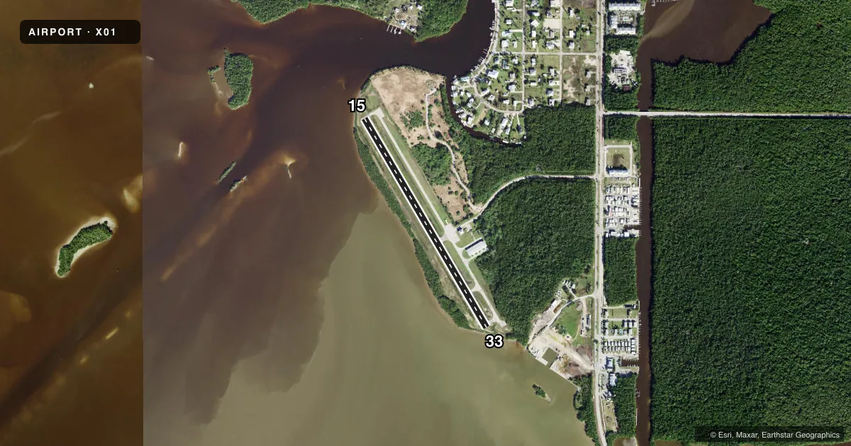
Runways & pattern
Full pagePattern entry · RWY 33
LEFT TRAFFICRunway end performance
| End | TORA | TODA | ASDA | LDA | VGSI | Approach lights | Obstruction |
|---|---|---|---|---|---|---|---|
| 15 | — | — | — | — | — | — | 14', brush, 230' from thr, 125' R of cntrln, slope 26 |
| 33 | — | — | — | — | — | — | 14', trees, 215' from thr, 130' R of cntrln, slope 25 |
Declared distances in feet. TORA = takeoff run available, TODA = takeoff distance, ASDA = accelerate-stop, LDA = landing distance.
Airport sketch
Runways drawn to scale from FAA survey coordinates, rendered over satellite imagery. Not for navigation.
Approaches & charts
Services on the field
Fuel grades, oxygen, maintenance, ramp storage and lighting — as declared to the FAA by the airport operator.
Fuel & services
- Fuel
- 100LL
- Oxygen (bottled)
- Not available
- Oxygen (bulk)
- Not available
- Airframe repair
- Not available
- Power plant repair
- Not available
- Other services
- CHTR
Ramp & ground
- Transient storage
- Tie-down
- Landing fee
- No fee published
- Customs
- Not available
- Lighting schedule
- SEE RMK
- Beacon schedule
- SS-SR
- Beacon
- White / Green (civil land)(WG)
- Wind indicator
- Lighted
- Segmented circle
- Yes
Fuel & FBOs
Cheapest 100LL and Jet A on the field and nearby. Always confirm with the FBO before taxi.
Airport notes
Surface conditions, obstructions, local procedures, lighting outages and other notes published with each FAA cycle.
General notes
- HIGH DENSITY BIRD POPULATION ON & AROUND ARPT.
- 10 FT TREES 125 -150 FT W OF RWY.
- PAEW INVOF RY 15/33 INDEFLY.
- DITCH 54 FT L OF CNTRLN FIRST 664 FT OF RY 33.
- RWY 15 AND RWY 33 SAFETY AREAS END AT END OF RWY. SAFETY AREAS MAY HOLD WATER AFTER HEAVY RAINFALL OR HIGH TIDAL EVENTS.
- BANNER TOW OPNS ON AND INVOF OF ARPT.
- FOR CD CTC MIAMI ARTCC AT 305-716-1731.
Lighting notes
- ACTIVATE - MIRL RY 15/33 - CTAF.
Fuel notes
- 100LLFUEL AVBL 24 HRS WITH CREDIT CARD.
Approach & departure obstructions
- 15RWY 15 APPCH SLP 26:1 TO MKD DTHR.
- 33RWY 33 APPCH SLP 25:1 TO MKD DTHR.
Other notes
- VFR ONLY.
- MANAGERALT CTC: SPENCER BRILLON (239) 252-8393
- 15/33RWY 15/33 IS NOW 60 FT WIDE ASPHALT SFC.
VFR map & nearby airports
VFR sectional. Tap any ICAO chip to open that airport.
Key facts · X01
Answer card- ICAO
- X01
- Name
- EVERGLADES AIRPARK
- Location
- EVERGLADES CITY, FLORIDA
- Elevation
- 4 ft MSL
- Traffic pattern altitude
- 1,004 ft MSL (1,000 AGL)
- Control tower
- Non-towered (use CTAF)
- Total runways
- 1
- Longest runway
- 15/33 · 2,400 ft
- Published ILS approaches
- 0
- Published frequencies
- 2
- Magnetic variation
- 2°
- Current flight rules
- VFR
- Current wind
- 300° at 4 kt
- Favored runway now
- RWY 33
Everglades Airpark is in Everglades City, Florida. The field elevation is 4 ft MSL. It has one runway. Runway 15/33 is 2,400 ft long with an asphalt surface, so plan your performance with the short field in mind. There is no control tower. CTAF and UNICOM are both 123.075.
No ILS approaches are published here. The airport is VFR only. Pattern altitude is not published, so use the standard 1,000 ft AGL for light piston operations unless the current FAA Chart Supplement says otherwise. The on-field FBO is Everglades Airpark. It carries 100LL. Fuel is available 24 hours with credit card.
There are a few things a first-time pilot should know before coming in. Published remarks call out trees west of the runway. They also note a ditch left of centerline on the first part of runway 33. Displaced threshold approach slopes are published on both ends. Banner tow operations also occur on and near the airport. Bird activity is high around the field. Medium intensity runway lights on runway 15/33 are activated by using the CTAF. If you need clearance delivery, contact Miami ARTCC at 305-716-1731. Check the current FAA Chart Supplement before departure for any updates to procedures or restrictions.