METAR & TAF X55
X55 does not publish a METAR.
Showing the nearest reporting station: KLEE (LEESBURG INTL) · 9.5 NM away. Conditions at X55 may differ.
METAR · KLEE
Observed 06:53Z
KLEE 270653Z AUTO VRB03KT 8SM CLR 27/25 A2993 RMK AO2 SLP133 T02670250 $
- Wind
- VAR @ 3 kt
- Visibility
- 8 SM
- Temp / Dew
- 27°C / 25°C
- Altimeter
- 29.93 inHg
- Clouds
- CLR
- Density alt
- 1,635 ft
- Ceiling
- Unlimited
- Rules
- VFR
Airport info & contacts
Manager on record, flight service, ARTCC, attendance schedule and pattern altitude — published by the FAA and refreshed every 28 days.
Location
- From city
- 3 NM E
- VFR sectional
- JACKSONVILLE
- ARTCC
- ZJX · JACKSONVILLE
- NOTAM facility
- PIE (NOTAM-D)
Airport manager
- Name
- YAS RAHMANPARAST
- Phone
- 786-395-5632
- Address
- 13354 SW 58TH AVENUE, MIAMI FL 33156
Flight service · Hours
- FSS PIE
- SAINT PETERSBURG1-800-WX-BRIEF
- Attendance
- 0900-SS
Frequencies
Tap any row to copy the frequency to your clipboard.
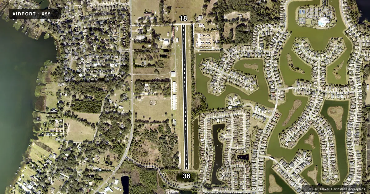
Runways & pattern
Full pagePattern entry · RWY 36
LEFT TRAFFICRunway end performance
| End | TORA | TODA | ASDA | LDA | VGSI | Approach lights | Obstruction |
|---|---|---|---|---|---|---|---|
| 18 | — | — | — | — | — | — | 4', fence, 0' from thr, 0' R of cntrln, slope 1 |
| 36 | — | — | — | — | — | — | 8', brush, 52' from thr, 15' R of cntrln, slope 6 |
Declared distances in feet. TORA = takeoff run available, TODA = takeoff distance, ASDA = accelerate-stop, LDA = landing distance.
Airport sketch
Runways drawn to scale from FAA survey coordinates, rendered over satellite imagery. Not for navigation.
Approaches & charts
Services on the field
Fuel grades, oxygen, maintenance, ramp storage and lighting — as declared to the FAA by the airport operator.
Fuel & services
- Fuel
- Not available
- Oxygen (bottled)
- Not available
- Oxygen (bulk)
- Not available
- Airframe repair
- Not available
- Power plant repair
- Not available
Ramp & ground
- Transient storage
- Tie-down
- Hangar
- Landing fee
- Yes
- Customs
- Not available
- Lighting schedule
- SEE RMK
- Beacon schedule
- SEE RMK
- Beacon
- White / Green (civil land)(WG)
- Wind indicator
- Lighted
- Segmented circle
- No
Fuel & FBOs
Cheapest 100LL and Jet A on the field and nearby. Always confirm with the FBO before taxi.
Airport notes
Surface conditions, obstructions, local procedures, lighting outages and other notes published with each FAA cycle.
General notes
- NO TGL ALLOWED ON THIS FAC.
- LDG FEE FOR ALL NON TENANTS INCLUDING FLIGHT SCHOOLS.
- NO GLIDERS ULTRALIGHTS SKYDIVING UNLESS EXPRESSED CONSENT BY MGR OR OWNER.
- FOR CD OR TO CNL IFR CTC ORLANDO APCH AT 407-852-7500.
- VISITORS WHO PARK MUST NTFY ARPT MGR (786-395-5632), OF ARRIVAL AND THEN MUST PARK ACFT ON NORTHERN-CENTRAL TIE-DOWN SPACE ON W SIDE OF RY.
Lighting notes
- ROTG BCN OPERS DUSK-2300. AFTER 2300, ACTVT - CTAF.
- ACTVT LIRL RWY 18/36 - CTAF.
Approach & departure obstructions
- 18RWY 18 HAS 4 FT FENCE 0 FT FM RWY END LEFT/RIGHT OF CNTLN.
- 18DTHR MKD WITH 3 TIRES AND LGTS PER SIDE.
- 18RWY 18/36 MKD BY TIRES AND NTSD LGTS. RWY 36 THR LGTS MISG. RWY 18 DTHR LGTS MISG.
- 18RWY 18 APCH RATIO 20:1 FM 63 FT TREES 710 FT FM DTHR.
- 36RWY 36 APCH RATIO 20:1 TO DTHR.
Other notes
- VFR ONLY.
- T-HNGRS AND BOX HNGRS FOR RENT PER YEARLY LEASE TERM.
- 5 TIEDOWN SPACES FOR RENT ON DLY, WEEKLY, MONTHLY BASIS.
VFR map & nearby airports
VFR sectional. Tap any ICAO chip to open that airport.
Key facts · X55
Answer card- ICAO
- X55
- Name
- MID-FLORIDA
- Location
- EUSTIS, FLORIDA
- Elevation
- 167 ft MSL
- Traffic pattern altitude
- 1,167 ft MSL (1,000 AGL)
- Control tower
- Non-towered (use CTAF)
- Total runways
- 1
- Longest runway
- 18/36 · 3,200 ft
- Published ILS approaches
- 0
- Published frequencies
- 3
- Magnetic variation
- 3°
- Current flight rules
- VFR
- Current wind
- 000° at 3 kt
- Favored runway now
- RWY 36
Mid-Florida (X55) is in Eustis, Florida. Field elevation is 167 ft MSL. The airport has one runway. Runway 18/36 is a 3,200 ft turf strip, which is the longest runway on the field. There is no control tower. CTAF is 122.8. Orlando Approach is listed on 135.3 for approach and departure. It is also the contact for IFR clearance delivery or IFR cancellation.
No ILS approaches are published here. Pattern altitude is not published, so plan on the standard 1,000 ft AGL for light piston unless the current FAA Chart Supplement says otherwise. The field uses low intensity runway lights on CTAF. The runway is marked by tires and nonstandard lights. Runway 36 threshold lights are missing. Runway 18 displaced threshold lights are missing. Runway 18 also has a fence close to the runway end, so pay close attention on short final. The approach to Runway 36 has a 20 to 1 obstacle clearance slope to the displaced threshold. The approach to Runway 18 has a 20 to 1 obstacle clearance slope from 63 ft trees located 710 ft from the displaced threshold.
There are no on-field FBOs listed. Visitors who park must notify the airport manager before arrival. Then park in the northern-central tiedown space on the west side of the runway. Landing fees apply to non-tenants. Touch-and-go operations are not allowed. Gliders, ultralights and skydiving are not allowed unless the manager or owner gives consent.