METAR & TAF X04
X04 does not publish a METAR.
Showing the nearest reporting station: KLEE (LEESBURG INTL) · 13.8 NM away. Conditions at X04 may differ.
METAR · KLEE
Observed 12:53Z
KLEE 271253Z 22006KT 10SM CLR 27/25 A2994 RMK AO2 LTG DSNT SW SLP135 T02720250
- Wind
- 220° @ 6 kt
- Visibility
- 10 SM
- Temp / Dew
- 27°C / 25°C
- Altimeter
- 29.94 inHg
- Clouds
- CLR
- Density alt
- 1,601 ft
- Ceiling
- Unlimited
- Rules
- VFR
Airport info & contacts
Manager on record, flight service, ARTCC, attendance schedule and pattern altitude — published by the FAA and refreshed every 28 days.
Location
- From city
- 4 NM NW
- VFR sectional
- JACKSONVILLE
- ARTCC
- ZJX · JACKSONVILLE
- NOTAM facility
- PIE (NOTAM-D)
Airport manager
- Name
- BOB JACKSON
- Phone
- 407-308-5904
- Address
- 1321 APOPKA AIRPORT RD HANGAR 37, APOPKA FL 32712
Flight service · Hours
- FSS PIE
- SAINT PETERSBURG1-800-WX-BRIEF
- Attendance
- 0800-1800
Frequencies
Tap any row to copy the frequency to your clipboard.
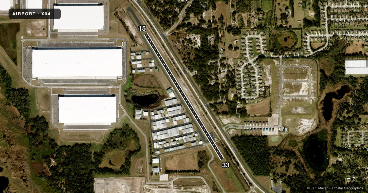
Runways & pattern
Full pagePattern entry · RWY 15
RIGHT TRAFFICRunway end performance
| End | TORA | TODA | ASDA | LDA | VGSI | Approach lights | Obstruction |
|---|---|---|---|---|---|---|---|
| 15 | — | — | — | — | — | — | 10', berm, 200' from thr, 125' R of cntrln, slope 1 |
| 33 | — | — | — | — | — | — | 57', trees, 2170' from thr, 150' R of cntrln, slope 34 |
Declared distances in feet. TORA = takeoff run available, TODA = takeoff distance, ASDA = accelerate-stop, LDA = landing distance.
Airport sketch
Runways drawn to scale from FAA survey coordinates, rendered over satellite imagery. Not for navigation.
Approaches & charts
Services on the field
Fuel grades, oxygen, maintenance, ramp storage and lighting — as declared to the FAA by the airport operator.
Fuel & services
- Fuel
- 100LLA
- Airframe repair
- Major
- Power plant repair
- Major
- Other services
- AVNCS,CHTR,INSTR,RNTL,SALES,SURV
Ramp & ground
- Transient storage
- Tie-down
- Hangar
- Landing fee
- No fee published
- Customs
- Not available
- Lighting schedule
- SEE RMK
- Beacon schedule
- SS-SR
- Beacon
- White / Green (civil land)(WG)
- Wind indicator
- Lighted
Fuel & FBOs
Cheapest 100LL and Jet A on the field and nearby. Always confirm with the FBO before taxi.
Airport notes
Surface conditions, obstructions, local procedures, lighting outages and other notes published with each FAA cycle.
General notes
- STEEP DROPOFF 63 FT FM SE END & APRXLY 60 FT OFF WEST & EAST EDGE.
- RY 15/33 RR PENETRATES 7:1 TRANS SFC EAST SIDE.
- RY 15/33 CLSD TO TOUCH AND GO LNDGS BY TRANSIENT HELICOPTERS.
- FOR CD OR TO CNL IFR IF UNA ON FSS FREQ, CTC ORLANDO APPROACH AT 407-852-7500.
- AUTOMATED UNICOM WX AND LGT - CTAF.
- NO OVNGT PRKG ON APRON BTN TWY A1 AND A2. NO OVNGT RAMP PRKG AVBL - TEXT 951-818-8408 FOR PAID PVT PRKG OPTIONS.
- PWRD PARAGLIDERS OPERATING W OF RWY 15/33.
- CALM WIND RWY 33.
- TOUCH AND GO OPS PROHIBITED IF THREE OR MORE ACFT IN THE TFC PAT.
Lighting notes
- ACTVT LIRL RWY 15/33 - CTAF.
Approach & departure obstructions
- 15RWY 15 HAS 10 FT BERM 200 FT FM RWY END 125 FT LEFT.
- 15RWY 15 APCH RATIO 20:1 FM DSPLCD THLD DUE TO 33 FT RR TRACK 420 FROM END OF RWY 125 FT L OF CNTRLN.
Other notes
- VFR ONLY
VFR map & nearby airports
VFR sectional. Tap any ICAO chip to open that airport.
Key facts · X04
Answer card- ICAO
- X04
- Name
- ORLANDO APOPKA
- Location
- APOPKA, FLORIDA
- Elevation
- 150 ft MSL
- Traffic pattern altitude
- 1,150 ft MSL (1,000 AGL)
- Control tower
- Non-towered (use CTAF)
- Total runways
- 1
- Longest runway
- 15/33 · 3,284 ft
- Published ILS approaches
- 0
- Published frequencies
- 4
- Magnetic variation
- 6°
- Current flight rules
- VFR
- Current wind
- 220° at 6 kt
- Favored runway now
- RWY 15
Orlando Apopka Airport sits in Apopka, Florida. The field elevation is 150 ft MSL. It has one runway, 15/33, which is 3,284 ft long and paved. There is no control tower. The published pattern altitude is not listed, so use the standard 1,000 ft AGL for light piston traffic unless ATC or the Chart Supplement says otherwise.
No ILS approaches are published here. The airport is VFR only. Runway 15/33 has activated low intensity lighting controlled by CTAF. Calm wind runway is 33. The published remarks also call out a railroad near the east side of the runway environment. There is a steep dropoff near the southeast end. There is also a berm near the Runway 15 end. That makes this a field where a stabilized approach and good spacing matter.
Two on-field FBOs are listed. Orlando Apopka Airport carries 100LL and Jet A. First Landings Aviation also carries 100LL and Jet A. For IFR cancel or clearance delivery help when you cannot use FSS, Orlando Approach is the published contact. Touch-and-goes are prohibited if three or more aircraft are in the pattern. Powered paragliders also operate west of Runway 15/33, so keep an eye out in the local area.